Development of Plate Tectonic Theory
Chris Johnson, Matthew D. Affolter, Paul Inkenbrandt, Cam Mosher and Charlene Estrada
Development of Plate Tectonic Theory
Wegener died in 1930 on an expedition in Greenland. Poorly respected in his lifetime, Wegener and his ideas about moving continents seemed destined to be lost in history as fringe science. However, in the 1950s, evidence started trickling, making continental drift a more viable idea. By the 1960s, scientists had amassed enough evidence to support the missing mechanism—namely, seafloor spreading—for Wegener’s continental drift hypothesis to be accepted as the theory of plate tectonics. Ongoing GPS and earthquake data analyses continue to support this theory. The next section provides the pieces of evidence that helped transform one man’s wild notion into a scientific theory.
Mapping of the ocean floor
In 1947 researchers started using an adaptation of SONAR to map a region in the middle of the Atlantic Ocean with poorly-understood topographic and thermal properties. Using this information, Bruce Heezen and Marie Tharp created the first detailed map of the ocean floor to reveal the Mid-Atlantic Ridge. This basaltic mountain range spanned the length of the Atlantic Ocean, with rock chemistry and dimensions unlike the mountains found on the continents. Initially, scientists thought the ridge was part of a mechanism that explained the expanding Earth or ocean-basin growth hypotheses. In 1959, Harry Hess proposed the seafloor spreading hypothesis that the mid-ocean ridges represented tectonic plate factories, where a new oceanic plate was issuing from these long volcanic ridges. Scientists later included transform faults perpendicular to the ridges to better account for varying movement rates between the newly formed plates. When earthquake epicenters were discovered along the ridges, the idea that earthquakes were linked to plate movement took hold.
Seafloor sediment, measured by dredging and drilling, provided another clue. Scientists once believed sediment accumulated on the ocean floors over a very long time in a static environment. When some studies showed less sediment than expected, these results were initially used to argue against continental movement. With more time, researchers discovered these thinner sediment layers were located close to mid-ocean ridges, indicating the ridges were younger than the surrounding ocean floor. This finding supported the idea that the sea floor was not fixed in one place.
Paleomagnetism
The seafloor was also mapped magnetically. Scientists had long known strange magnetic anomalies that formed a striped pattern of symmetrical rows on both sides of mid-oceanic ridges. These features were unusual because the north and south magnetic poles within each stripe were reversed in alternating rows. By 1963, Harry Hess and other scientists used these magnetic reversal patterns to support their model for seafloor spreading (see also Lawrence W. Morley )
Paleomagnetism studies magnetic fields frozen within rocks, basically a fossilized compass. The first hard evidence to support plate motion came from paleomagnetism.
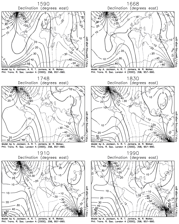
This animation shows how the magnetic poles have moved over 400 years.
Igneous rocks containing magnetic minerals like magnetite typically provide the most useful data. In their liquid state as magma or lava, the minerals’ magnetic poles align with the Earth’s magnetic field. When the rock cools and solidifies, this alignment is frozen into place, creating a permanent paleomagnetic record that includes magnetic inclination related to global latitude and declination related to magnetic north.
Scientists had noticed for some time the alignment of magnetic north in many rocks was nowhere close to the earth’s current magnetic north. Some explained this away as part of the normal movement of the earth’s magnetic north pole. Eventually, scientists realized adding the idea of continental movement explained the data better than pole movement alone.
Wadati-Benioff Zones

Around the same time, mid-ocean ridges were being investigated, other scientists linked the creation of ocean trenches and island arcs to seismic activity and tectonic plate movement. Several independent research groups recognized earthquake epicenters traced the shapes of oceanic plates sinking into the mantle. These deep earthquake zones congregated in planes that started near the surface around ocean trenches and angled beneath the continents and island arcs . Today these earthquake zones are called Wadati-Benioff zones.
Based on the mounting evidence, the theory of plate tectonics continued to take shape. J. Tuzo Wilson was the first scientist to put the entire picture together by proposing the opening and closing of the ocean basins. Before long, scientists proposed other models showing plates moving with respect to each other, with clear boundaries between them. Others started piecing together complicated histories of tectonic plate movement. The plate tectonic revolution had taken hold.


