Relative Dating and Unconformities

Figure Above: Determining ages of landscapes. A rock sequence on which a current landscape is depositing rocks is always older than the landscape.
How do we use rock layers to determine the age of layers?
When we examine the first drawing above we can ask ourselves what happened between the tilted layers on the bottom and the flat layers on top? The tilted layer was eroded flat before the new layer was deposited on top. So the sequence of events would be:
- Sedimentary rocks are deposited in flat layers.
- The sedimentary rocks are tilted through some kind of event and then eroded flat.
- A new layer was deposited on top of the tilted layers forming a disconformity between the two groups of rocks.
If you can date the sediments in both the tilted layers and the flat top layer then you can get an estimate of when the tilting event occured.
Lava flows are excellent for dating the age of rocks through radioactive decay but you can also use them to establish relative ages of the rocks above and below the lava flows. If the lava flow in the second image above is 5 million years old then you know the rocks below the the lava flow must be older than 5 million.

Figure Above: Other indicators of landscape age. A surface with well-developed soil is older than one with less soil. The elevation of a river terrace indicates the old elevation of the river before the river eroded it down.
A landscape surface develops more soil if it remains undisturbed by erosion and deposition. A surface with a thick layer of soil indicates old age. Rivers cut their way through landscapes leaving behind terraces (the old elevation of the river). Geologists can use terraces to establish relative ages for when the river eroded the landscape. The highest terrace is the oldest.
Unconformities
Unconformities represent a gap in time when the landscape is being eroded away. Keep in mind that we know about the geologic history of the Earth because of the rocks we can see and examine. If the rocks are missing because of erosion and weathering then we have no record of what existed during that time period. Unconformities are a part of landscape evolution. In the image above a gray limestone is deposited under the sea. The sea regresses and the limestone bed is folded into an anticline. The top of the fold is eroded flat. A conglomerate layer is deposited on top of the limestone and erosion surface. An angular unconformity is formed.The unconformity represent a time of erosion and a gap in geologic time history.

Figure Above: What does an unconformity represent? If a gray limestone is first deposited underwater, it might later become folded and much later have the overlying sediment on it eroded away by rivers as the area experiences a regression. Although the limestone is folded, a horizontal layer of conglomerate may be deposited directly over it. The missing time from when the sediment was eroded away between the limestone and the conglomerate is an unconformity.

In the Figure Above are some examples of unconformities.

Figure Above: How does a nonconformity form? Nonlayered rock (such as igneous basement rock) is uplifted and eroded. A sedimentary layer might be deposited directly over the basement rock. The nonconformity is specifically resulting from the igneous rock being below the erosional surface.
When metamorphic or igneous rock is below the erosional surface then the type of unconformity created is called a nonconformity. This is different from an intrusion contact, where magma melts its way into a rock and solidifies because there is evidence of erosion at the nonconformity line.

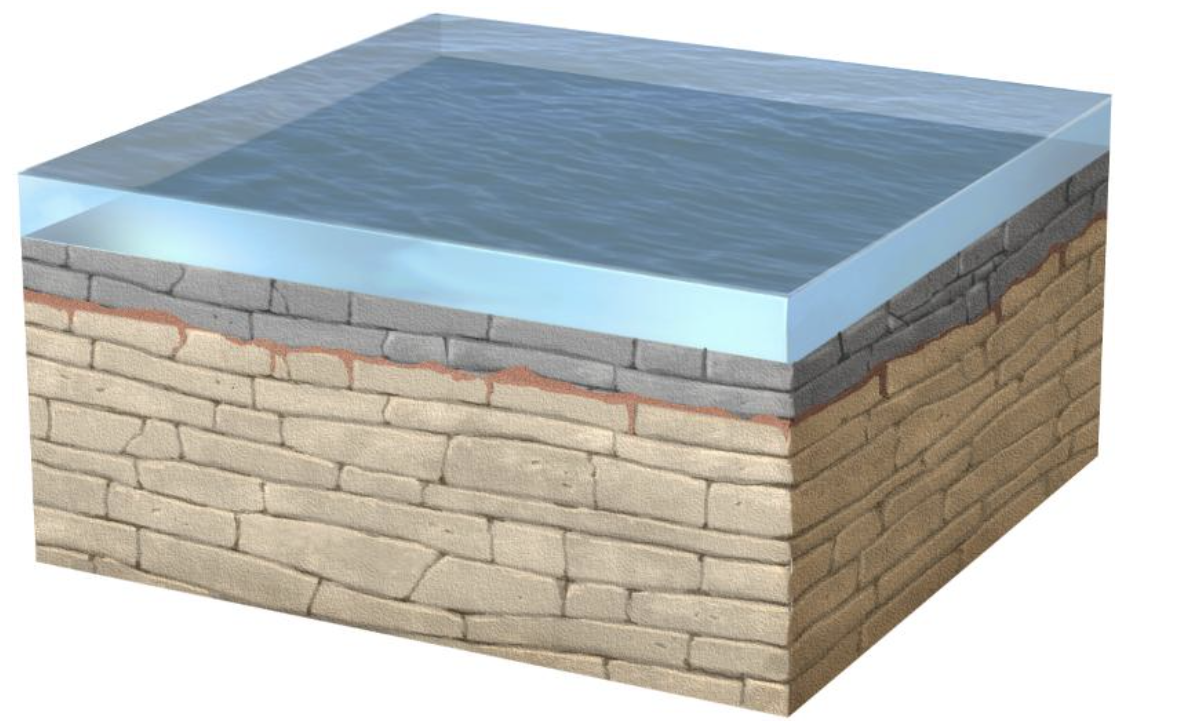
Figure Above: How do disconformities form? Horizontal sedimentary layers (limestone) form. Weathering erodes the surface. The eroded surface is covered by a new sedimentary rock (in this example, more limestone)
In a disconformity, flat-lying sedimentary rocks are deposited. The sedimentary rock is eroded for some period of time. After some time, the area changes from a time of erosion to a time of deposition and a new sedimentary layer is deposited on top of the old layer. The boundary between the two layers is the disconformity. In an angular unconformity, the layers are tilted or folded during the middle stage.

Figure Above: Example of a Disconformity between a Devonian limestone that is light gray, and a Mississippian Limestone that is dark gray.