
7 Water Resources
Learning Objectives
After studying this chapter, you should be able to:
- Demonstrate an understanding of how much water is available on Earth and how it is distributed
- Explain how water scarcity affects people in different parts of the world
- List several major water pollutants and their sources
- Explain how human modifications of natural water systems can be both beneficial and destructive
- Demonstrate knowledge of some of the major regulations related to water in the USA
Water Distribution and Use
Why do scientists spend time looking for water on other planets? Why is water so important? It is because water is essential for life as we know it. Water is one of the more abundant molecules and the one most critical to life on Earth. Approximately 60–70 percent of the human body is made up of water. Without it, life as we know it simply would not exist. In recent years, we have seen a rise in conflicts and dispute about water. Fortunately, most of the conflicts have ended up in the courts instead of the battlefields. This chapter is devoted to this precious resource that sustains our planet and its living things.
Recall that most of the water on the planet is in oceans and unavailable for human consumption due to its high salt content. Of all the water in the world, only about 3% is freshwater, and only a tiny portion of that fresh water is available for human consumption (the other freshwater is locked up in ice). Of this available fresh water, most is found as groundwater below the surface of the Earth. Only 0.3% of the world’s freshwater is surface water in rivers, lakes, and swamps. Surface water is easier to withdraw for human use than groundwater, but many countries depend on the withdrawal of groundwater because surface water is so limited.
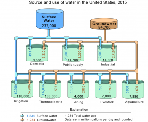
The largest percentage of water withdrawn for human use in the US goes to cooling equipment used to generate thermoelectric power, such as in coal-powered or nuclear generators (Figure 1). Agriculture accounts for the second largest amount of water withdrawn. This includes water used for irrigation of crops, for livestock animals, and for aquaculture (fish farming).
Knowledge Check
Water Storage on Earth
The major water pools, or storage locations, on Earth are oceans, glaciers, groundwater, rivers, and lakes. Water spends different amounts of time in the various pools. The main factors that control the amount of time water stays in a given pool are the amount of water in the pool and how fast water moves in and out. The water cycle represents a continuous global cycling of water from one pool to another.
Streams and Rivers
A river forms from water moving from a higher altitude to a lower altitude, under the force of gravity. When rain falls on the land, it either evaporates, seeps into the ground, or becomes runoff (water running on the surface). When water runs on the land surface it usually converges as it moves towards lower elevation. The converging runoff can concentrate into single channels of conveyance called creeks, streams, or rivers. Usually, these start as small rills and rivulets that would join up downhill into larger streams and creeks which can also join up downstream to form even bigger rivers. The streams, creeks, and rivers that join up to form a larger river are called tributaries (Figure 2). The land area drained by a river and all its tributaries is called a watershed.
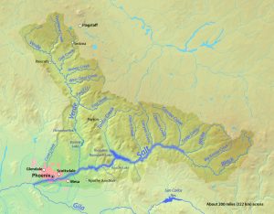
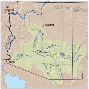
The US has numerous rivers that run throughout the nation’s landscape. It is estimated that the US has over 200,000 rivers, with the Mississippi River being the largest by volume despite it only being the second longest. The Missouri River is the longest river in the US. In Arizona, the main rivers are the Colorado (which runs through the Grand Canyon), the Gila, the Salt, and the Verde. There are also several smaller rivers and streams, some of which only flow during wet periods (Figure 3).
Rivers contain important biological communities and provide opportunities for recreation such as swimming, fishing, and white water rafting. Major cities, communities, factories, industries, and power stations are also located along rivers. It is, therefore, very important to protect the quality and integrity of rivers all over the world.
Unfortunately, most of the rivers in the world are too polluted to support certain human activities, especially swimming, fishing, and drinking. Close to half of the rivers in the US have been deemed too polluted to support swimming and fishing. A lot of the rivers have also been channelized, dredged, or impounded by dams which have decreased their ability to support human and biological activities.
Lakes, Reservoirs, and Ponds
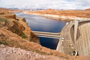
If water flows to a place that is surrounded by higher land on all sides, a lake will form. A lake, pond or reservoir is a body of standing water on the land surface. When people build dams to stop rivers from flowing, the artificial lakes that form are called reservoirs (Figure 4). (Note: This meaning of the word reservoir is different from the way it is used when referring to the water cycle. In that case, reservoir refers to any location where water is stored.) It is estimated that over 300 million water bodies in the world are lakes, reservoirs, and ponds. Most of the Earth’s lakes (about 60%) are found in Canada. Even though lakes and rivers contain less than 1% of the Earth’s water, the US gets over two-thirds (70%) of its water (for drinking, industry, irrigation, and hydroelectric power generation) from lakes and reservoirs. Lakes are also the cornerstone of the US’s freshwater fishing industry and are the backbone of the nation’s state tourism industries and inland water recreational activities. Arizona is home to over 100 reservoirs, but only two natural lakes, Mormon Lake and Stoneman Lake, both in northern Arizona.
Over 600,000 river miles have been dammed in the US to create reservoirs. The benefits of dams to humans include providing a source of water, providing recreational opportunities, and reducing local flooding. On the other hand, dams can also have negative impacts on people and the environment. They can lead to increased severe flooding downstream of the dam, especially during high rain events. Damming a river can trap stream sediments (soil particles), resulting in reduced nutrient supply downstream as well as increased deposition behind the dam. This shift in sediment flow can disrupt and damage aquatic habitats and can increase downstream stream erosion due to a lack of sediment supply. Dams can also prevent certain aquatic organisms from migrating either upstream or downstream, therefore reducing their range and abilities to survive environmental changes as well as cutting them off from spawning areas. Construction of dams can also result in displacement of the local people and loss of traditional lands and cultural history. Over 1.2 million people were displaced when the Chinese government built the Three Gorges Dam, the largest dam in the world, on the Yangtze River.
Knowledge Check
Wetlands
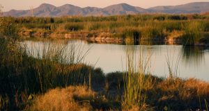
A wetland is an area that is home to standing water for notable parts of the year, has saturated soils for a large part of the year, and has plants that require large amounts of water to survive (Figure 5). Swamps, marshes, and bogs are all types of wetlands. Because of the constant supply of water and high levels of soil nutrients, wetlands produce a great deal of food that supports a wide variety of species. For example, one-third of all American bird species can be found in wetlands.
Oceans
As you have probably already guessed, oceans are an important component of the water cycle because they store the majority of all water on Earth (about 95%). Most of the major rivers drain into oceans. The five oceans covering the surface of the Earth are the Atlantic, Indian, Pacific, Arctic, and the Southern Ocean). Approximately 90% of the water that is evaporated into the water cycle comes from the ocean. Oceans are an important and large part of the hydrologic cycle, with high biological diversity and many landforms.
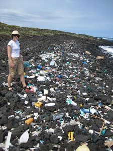
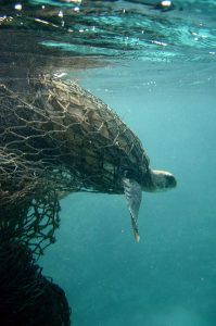
Unfortunately, humans have degraded the oceans and their life through pollution, overfishing, carbon dioxide acidification, and global warming. Plastic pollution in the ocean has become an especially serious problem in the last few decades. By 2050 there will be more plastic than fish in the ocean, by weight. Individuals are responsible for a significant portion of plastic pollution, but the majority of plastic in the ocean comes from the fishing industry (Figure 6).
 |
 |
Groundwater
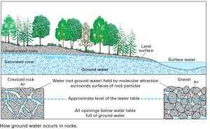
Almost 99% of the available freshwater is found below the surface as groundwater. When precipitation falls, some of the water runs off on the surface while some infiltrates into the ground, to be stored in porous rock layers. Groundwater is replenished when water moves from the surface, through unsaturated rocks or sediment (unsaturated), all the way down the saturated parts (saturated zone) in a process called infiltration and becomes groundwater (Figure 8). The top of the saturated portion is called the water table, which is the boundary between the saturated and unsaturated zones. Groundwater is found in aquifers, which are bodies of rock or sediment that store large amounts of usable water in their pores. Groundwater will continue to flow until it emerges as a spring, or discharges into surface water bodies on the land or in the ocean. To utilize groundwater, we drill holes (wells) into the ground and pump the water out.
Groundwater is a renewable resource because it is naturally replenished by precipitation. But it can become nonrenewable if the water is removed faster than it can be replenished. This is a major environmental concern in many arid regions, such as the American West.
Water Scarcity
Water has been identified as one of the major environmental crises facing the world today. More than one billion people in the world lack access to clean drinking water. The demand for water has grown at a rapid pace in response to the rate of global population growth. It is predicted that over the next two decades, the average supply of water per person will drop by a third.
There is enough fresh water on Earth to supply every human being with enough drinking water. The main problem we face with regard to water is that it is unevenly distributed, polluted, mismanaged, and wasted. Tony Allan, the author of Virtual Water, asserts that water follows money. This refers to the fact that rich countries and societies with money and affluence have more access to safe drinking water even when they live in regions without much water. It also means that areas with large supplies of water can still have water scarcity if they lack the financial resources to build the infrastructure to supply people with safe clean drinking water.
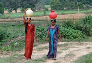
Water scarcity is caused by the demand for water being greater than the supply. Scarcity can be defined as either physical scarcity or economic scarcity. Physical water scarcity is a situation where there is an actual shortage of water, regardless of quality or infrastructure. It is estimated that about 1.2 million people around the world are experiencing physical water scarcity. Economic scarcity is a condition where countries lack the financial resources and/or infrastructure to supply their citizens with reliable safe drinking water. About 1.6 billion people are experiencing economic water shortage; most of them live in less industrialized countries. For a lot of places in the world, scarcity is a transient condition that can be reduced or eliminated by installing the right infrastructure. The major problem in developing countries is the lack of political, financial, and physical structures to provide water to everyone. A few rich people in these countries get the clean water while the majority of the people who cannot afford to pay for it are left out. People in these communities (usually women and children) must walk long distances to get untreated and contaminated water for drinking and other household needs (Figure 9).
Arid regions like the Sonoran Desert face great risk of water scarcity as overuse threatens already limited supplies and climate change leads to extended periods of drought.
Water Pollution
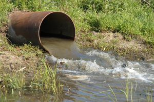
Water pollution is a major problem facing many of our surface water and groundwater sources. Contamination can both be natural or anthropogenic (caused by humans). Human sources of contamination can be categorized as either point sources or non-point sources. Point source pollution is water pollution coming from a single point, such as a sewage pipe (Figure 10).
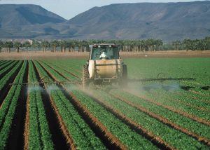
Non-point source pollution is pollution discharged over a wide land area rather than one specific location, such as agricultural runoff and urban stormwater runoff. Non-point source pollution contamination occurs when rainwater, snowmelt, or irrigation washes off plowed fields, city streets, or suburban backyards (Figure 11). Non-point sources of pollution are often harder to manage because the pollutants have no single distinct source that can be easily cleaned up.
Types and Sources of Water Pollution
Contamination of water resources comes in the form of physical, biological, and chemical pollution.
Physical Pollution
The most significant physical pollutant is excess sediment in runoff from agricultural plots, clear-cut forests, improperly graded slopes, urban streets, and other poorly managed lands. Other physical pollutants include a variety of plastic refuse products such as packaging materials and water bottles.
Another form of physical pollution is extreme temperature changes. Power plants and other industrial facilities that use natural water bodies for cooling are the main sources of temperature pollution. Temperature typically affects the metabolism of aquatic fauna in a negative way and can encourage the overgrowth of algae.
Biological Pollution
Biological pollution refers to pathogenic microorganisms and organic wastes that come from living organisms. Pathogenic microorganisms are bacteria, viruses, and protozoa that cause diseases in humans. One very common waterborne pathogen is coliform bacteria, which includes E. coli and related species. Some coliforms are spread through human and animal feces, so they are known as fecal coliforms. These pathogens may enter the water supply through animal manure on farms and untreated sewage. They are also a major cause of foodborne illness when manure or contaminated water are applied to food crops. At any given time, close to half the population in developing countries suffers from a waterborne illness caused by pathogenic microorganisms.
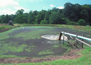
Organic wastes are also considered biological pollutants because they are derived from living organisms. These include animal waste (manure and urine) and plant debris. Major sources of organic waste include untreated sewage, industrial animal farms, and paper mills (Figure 12).
Chemical Pollution
Chemical pollution includes things such as heavy metals, pesticides and herbicides, and fertilizers. Heavy metals include mercury, lead, arsenic, and cadmium. Mining operations are a major source of these metals, but they can also come from old corroded plumbing pipes. Improper storage and use of automotive fluids produce common organic chemicals causing water pollution. These chemicals include methanol and ethanol (present in wiper fluid); and gasoline and oil compounds such as octane. Most of these are considered non-point sources since their pathway to watercourses is mainly overland flow.
High concentrations of nitrogen (N) and phosphorus (P) in water can lead to eutrophication. Eutrophication is an excess of nutrients in a body of water that leads to the overgrowth of algae and aquatic plants. You are seeing eutrophication whenever you notice a greenish tint to the water in a pond or lake. These nutrients are primarily coming from:
- treated wastewater (laden with P and N) being dumped into the river from sewage plants,
- agricultural areas where farmers allow livestock direct access to the stream, and
- agricultural areas where there is intense fertilizer application, and from landscapes (homes, gardens, golf courses) with fertilizer runoff.
The N and P act as fertilizers in the water and promote algal blooms (overgrowth of algae). As the algae die, they are decomposed by bacteria in the water. These bacteria use up the oxygen in the water, and the low dissolved oxygen (DO) levels can result in “fish kills” where large numbers of fish, and other aquatic life, die because of suffocation. Oxygen makes up about 21% of the molecules in the air, but it is at a much lower concentration of water. Dissolved oxygen in water is measured in parts per million (ppm) or milligrams per liter (mg/L). Fish kills generally happen when the DO level in water falls below 2 ppm (equivalent to 2 mg/L). DO levels between 2 and 5 ppm increase stress on fish and other living things in the water, making them more susceptible to disease. A DO concentration above 5 ppm is considered optimal for aquatic life.
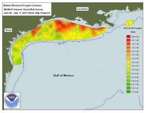
The dead zone in the Gulf of Mexico is a large area of low dissolved oxygen that has a negative impact on the fishing industry along the Gulf Coast near the mouth of the Mississippi River. The dead zone occurs annually when fertilizers from farm fields in the Midwest wash down the Mississippi River and are dumped into the Gulf (Figure 13).
Water Management
Pollution control begins with testing and monitoring of water quality. Water quality is usually monitored using easy-to-measure indicators such as pH, conductivity, temperature, fecal coliform bacteria, dissolved oxygen, macroinvertebrates, and algae. Polluted sites typically have reduced DO levels, lower pH (more acidic), higher nutrient levels, more bacteria, and higher temperatures compared to less impacted or pristine sites.
Non-point source control relates mostly to land management practices in the fields of agriculture, urban design, and sanitation. Agricultural practices leading to the greatest improvement of sediment control include contour grading, avoidance of bare soils in rainy and windy conditions, polyculture farming resulting in greater vegetative cover, and increasing fallow periods. Minimization of fertilizer, pesticide and herbicide runoff is best accomplished by reducing the quantities of these materials, as well as applying fertilizers during periods of low precipitation. Other techniques include avoiding highly water-soluble pesticides and herbicides, and the use of materials that have the most rapid decay times to benign substances.
In the case of urban stormwater control, good urban planning and design can minimize stormwater runoff. By reducing impermeable surfaces (pavement that doesn’t allow water through), cities can reduce the amount of surface water runoff that carries pollutants into surface water and causes flooding. Additionally, the use of native plants and xeriscape (low water) techniques reduces water use and water runoff and minimizes the need for pesticides and fertilizers (Figure 14).

Clean Water Act
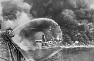
The Cuyahoga River in Northeastern Ohio cuts through Cleveland and feeds into Lake Erie. This river was so polluted from industrial waste that it caught fire multiple times from the 1940s to 1960s (Figure 15). One of these fires in 1969 caused a strong public outcry that fueled the emerging environmental movement and eventually led to the passage of the Clean Water Act (CWA) of 1972. This regulation includes numerous programs for water quality improvement and protection. The US Environmental Protection Agency (EPA) works with its federal, state and tribal regulatory partners to monitor and ensure compliance with clean water laws and regulations in order to protect human health and the environment. The Clean Water Act is the primary federal law governing water pollution.
The ultimate goals of the Clean Water Act are to establish zero pollutant discharge and to increase the amount of fishable & swimmable waters in the country. The act covers both point sources and non-point sources of pollution. One main component of the CWA is regulations on industrial and municipal discharges into navigable US waters. The act is designed to be a partnership between states and the federal government. The federal government sets the agenda and standards while the state carries out the implementation of the law. States also have the power to set standards that are more stringent than the federal standards, if needed. Under the CWA, discharge into US waters is only legal if authorized by a permit. The permits require the use of control technology to reduce and prevent pollution. Negligent or knowing violation of the CWA can result in a prison sentence of up to three years and/or a fine of up to $50,000 per day. These penalties increase for repeat offenders.
Thanks to the Clean Water Act and subsequent regulations limiting water pollution, burning rivers are a thing of the past in the United States. The Act has prevented billions of pounds of point-source pollution from entering our rivers, and the number of waterways that meet clean water standards has more than doubled. However, water pollution is still a significant national and global problem nationally and globally that will require further government regulation to solve.
Knowledge Check
Attribution
Introduction to Environmental Science, 2nd edition, by Carolyn Zender, Kalina Manoylov, Samuel Mutiti, Christine Mutiti, and Allison VandeVoort, modified by Sean Whitcomb. License: CC BY-NC-SA
Media Attributions
- water-use-pipe-diagram-2015 © USGS is licensed under a Public Domain license
- Salt_River_Map © Shannon1 is licensed under a CC BY-SA (Attribution ShareAlike) license
- Arizona_river_map © Kmusser is licensed under a CC BY-SA (Attribution ShareAlike) license
- Lake_Powell_01 © Adam Kliczek
- Yuma-East-Wetlands-Restoration-YCNHA © Yuma Crossing National Heritage Area is licensed under a Public Domain license
- Plastic_pollution © NOAA is licensed under a Public Domain license
- Sea_turtle_entangled_in_a_ghost_net © NOAA is licensed under a Public Domain license
- groundwater-diagram © USGS is licensed under a Public Domain license
- WomenCarryingWater © sarangib is licensed under a Public Domain license
- Discharge_pipe © USDA is licensed under a Public Domain license
- Farm_pesticides © NRCS is licensed under a Public Domain license
- Manure_lagoon © NRCS is licensed under a Public Domain license
- Dead_Zone_NASA_NOAA © NOAA is licensed under a Public Domain license
- Xeriscape © Jeremy Levine is licensed under a CC BY (Attribution) license
- Cuyahoga River fire

(NRCS_Photo_Gallery).jpg)