
Claire Chadwick; Lauren Maurizio; Robin Humphreys; and Vijay Vulava
Erosion of Landscapes
The Grand Canyon in the southwestern US is an incredible example of the elements of nature that reshape the surface of the Earth by the process of weathering and erosion. Over many million years, the Colorado River transformed the Colorado Plateau by eroding the weathered surface rocks and transported the sediment away, leaving behind the Grand Canyon. Watch this short video that describes how plate tectonics, weathering, and erosion can create such landscapes. As you watch the video, pause the video to write down the facts and terms that are mentioned, including the types of rocks found here.
Exercise 1 – The Colorado River and the Grand Canyon
Use the resources below to answer the following questions.
- Watch the video above and make notes.
- 5 Weathering, Erosion, and Sedimentary Rocks – An Introduction to Geology (opengeology.org)
- How are weathering and erosion different?
- The Colorado Plateau formed at this type of plate boundary.
- What is the approximate age of the rock at the bottom of the Grand Canyon?
- What did the oceans deposit on top of these basement rocks for more than a billion years?
- What are the three types of materials that were deposited by the oceans as they rose and fell?
- These sediments were transformed into sedimentary rocks as part of the natural rock cycle. Match the sediment source to the appropriate sedimentary rock.
- What is the approximate age of the Grand Canyon and the Colorado River?
- The process by which the Colorado River removed the sediment is called:
- The Colorado River made the canyon deep. What are two other factors (agents of erosion) that made the canyon wide?
- Tectonic forces continue to push the Colorado Plateau upward causing the Colorado River to flow faster. This increased river flow causes increased rock erosion. T/F
- Erosion by the Colorado River is estimated to remove 500,000 tons of sediment each day. Where does this sediment go?
- The Colorado River needed approximately 6 million (6,000,000) years to carve the 1-mile (5,280 ft) deep Grand Canyon. Calculate the average erosion rate for each year.
- The Grand Canyon continues to grow large today. T/F
Sediment Deposition and Sedimentary Rocks
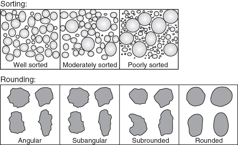
In the above section, we learned about how weathering and erosion can modify large landscapes. Rivers such as the Colorado River originate in the Rocky Mountains where the terrain is steep resulting in a high-energy, turbulent flow. Here, large-sized sediment, including boulders and large cobbles, can be transported by the streams. When streams exit steep slopes, they slow down, lose energy, and meander – here smaller-sized sediments are transported by streams. Finally, when streams enter oceans or large reservoirs, they are only able to carry the smallest sediment due to extremely low energy in these streams. As the sediments are transported farther from the source, they become more rounded. The sediment can also be sorted based on the medium of transport. For example, slow-moving streams can only transport fine sediment (well-sorted), while fast-moving streams can transport boulder- to mud-sized sediment (poorly-sorted). Examine the image below for an idea of how sediments can be “sorted” or “rounded” in different environments from high in the mountains to coastal environments. Note that sediments are referred to as clasts.
Exercise 2 – Sedimentary Rocks
Use the resources below to answer the following questions.
- 5 Weathering, Erosion, and Sedimentary Rocks – An Introduction to Geology (opengeology.org)
- Chapter 6 Sediments and Sedimentary Rocks – Physical Geology – 2nd Edition (opentextbc.ca)
- What is the largest transporter of sediments on Earth?
- Rank the following stream environments from high energy to low energy.
- Rank the following sediment types with stream environments.
Let’s consider the two main types of sedimentary rocks – clastic and non-clastic (chemical, biogenic, and organic) sedimentary rocks. Watch the videos below by Dr. Scott Brande of the University of Alabama.
- SedRx Study Guide – Classification (georockme.com)
- Your sedimentary rock collection
- Identify the three clastic sedimentary rocks that are part of your sedimentary rock set.
- Match the three clastic sedimentary rocks with the sediment size.
- Identify the non-clastic (chemical/organic/biogenic) sedimentary rocks from your rock set.
- What mineral is predominant in the non-clastic sedimentary rocks of your rock set?
- Match the sedimentary rocks from your Lab Kit to the letters A through E in the table below. Note how the clast sizes vary based on the energy of the depositional environments.
Summary table for the sedimentary rocks from your rock set. Type Clast Size Clast Size Pebble Sand Silt/Mud Energy High Medium Low Clastic A B C Non-clastic D-Chemical E-Organic
Weathering is a process that turns any rock into smaller particles such as sediment or soil.
Erosion is a mechanical process that removes the weathered material from the source rock. Usually, this process is facilitated by water, wind, gravity, or ice.
A measure of the uniformity of the sediment grains within a sample.
A clast is a fragment of rock or mineral, ranging in size of a clay particle to as big as a large boulder.
