
Claire Chadwick; Lauren Maurizio; Robin Humphreys; and Vijay Vulava
Introduction to Streams
In the previous section, we explored the role of streams as a significant agent of mountain and landscape erosion. In this section, let’s explore how streams work. The figure below provides a basic conceptualization of a river system that originates in mountains (headwaters) and discharges into an ocean (mouth).

Exercise 3 – Streams
Consult the resources below to answer the following questions:
- 11 Water – An Introduction to Geology (opengeology.org)
- Chapter 13 Streams and Floods – Physical Geology – 2nd Edition (opentextbc.ca)
- 13.4 Stream Types – Physical Geology – 2nd Edition (opentextbc.ca)
- What is the primary physical force that causes streams to flow downhill?
- Streams normally flow in a channel. Where is the channel represented in the figure above?
- When streams overflow this channel and flood the adjacent land, what is this area of land called?
- Describe the stream gradient.
- Channel shape (straight vs. meander) is determined by the velocity of the stream. Identify the section of a typical stream system where the channel is straight.
- Identify the sections of a typical stream system where the channel typically meanders.
- Headwaters of a stream are associated with ____ gradient.
- A stream near the mouth is associated with ____ gradient.
- What is the sinuosity of a stream?
- Match the sinuosity of a straight channel stream with a meandering stream.
Meandering Streams
A stream that flows on a wide, flat floodplain with a low gradient typically carries only sand-sized and finer sediments and develops a sinuous (curvy) flow pattern. When a stream flows around a corner, the water on the outside has farther to go and tends to flow faster. This leads to erosion of the banks on the outside of the curve, deposition on the inside, and the formation of a point bar. Over time, the sinuosity of the stream becomes increasingly exaggerated, and the channel migrates around within its flood plain, forming a meandering pattern.
In the animation and video below you see how meanders develop in different geological settings.
See the image below of a meandering stream in central Alaska – can you identify the different features in this meandering stream?
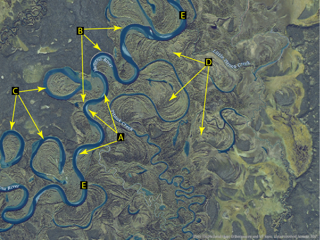
Exercise 4 – Meandering Streams
Consult the above videos and the resources below to answer the following questions:
- In which part of the meandering section of a river is the velocity of the stream higher?
- Where does erosion occur in a meander?
- Where does sediment accumulate in a meander?
- What feature forms when a meander becomes so pronounced that it is cut off from the main channel?
- Using Figure 4 above, match the letters to the appropriate terms: Channel, Floodplain, Point Bar, Cut Bank, Oxbow Lake
- Identify the location in Figure 4 where erosion occurs.
- Identify the locations in Figure 4 where deposition occurs.
- What kind of a meander is present in the Yakima River as described in the video above.
- Will this kind of exaggerated meander develop an oxbow lake?
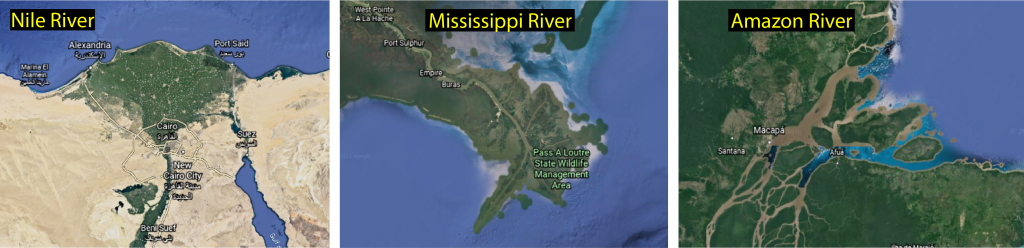
Deltas
When a river eventually drains into the ocean or a large reservoir, it loses energy and deposits sediment. In the short video below, the narrator not only shows how deltas form but also how different types of deltas form.
Exercise 5 – Deltas
Watch the above video to answer the following questions:
- What is the name of the feature that forms when sediment piles up at the mouth of a river?
- When a stream meets the ocean what happens to its energy and velocity?
- If the stream velocity remains high at the mouth, what kind of a delta forms?
- If ocean tides dominate at the mouth, what kind of a delta forms?
- Examine Figure 5 below and match the type of delta to the river.
Modeling Stream behavior and Sediment Transport
Stream behavior and sediment transport can be studied from pictures taken by satellites. They can also be studied in the lab by using stream models shown in the videos below. The models show stream evolution in short time scales and can highlight the dynamic processes that shape landscapes. Some of the features covered earlier in the lab should become apparent as you watch the videos of stream models below.
Exercise 6 – Streams and Sediment Transport
- Watch the videos above and observe the locations of point bars, cut banks, and the flood plain on the stream model.
- Answer the questions based on the descriptions in the first video.
- Observe the formation of the stream channel in the stream table. Is the channel meandering or straight?
- Where is the sediment erosion taking place?
- Where is the sediment deposition taking place?
- What effect do trees typically have on the erosion rate of cut banks?
- What effect do man-made structures like houses have on the erosion rate of cut banks?
- Observe the formation of the delta. What size sediment (color) is being deposited closer to the mouth near the channel?
- Where does the sediment that is found in the delta typically originate?
- What does this tell you about sediment that is found along coastlines and in the ocean?
