
Tides
Watch the video below to learn about one of the most important processes that impact coastlines on Earth.
Exercise 6 – Tides
Also use the information at What are Tides – Tides and Water Levels: NOAA’s National Ocean Service Education for answering the questions below.
- What are tides?
- The gravitational pull of these celestial objects causes tides on Earth.
- The gravitational pull of this celestial object has more impact on tides on Earth.
- There are usually ___ high tides or low tides in a day.
- When there are two sets of tides in a day, they are called:
- When the gravitation pull of these celestial objects aligns, the tides are higher than normal. T/F
- The higher-than-normal tides are called:
- When the gravitation pull of these celestial objects is perpendicular to each other, the tides are lower than normal. T/F
- The lower-than-normal tides are called:
- King tides occur when these celestial objects are closer than normal to Earth, creating a higher-than-normal spring tide. T/F
- What is the tidal range?
Since Earth is not a perfect sphere and has large continents blocking the free movement of tidal bulges on the ocean surface, areas around the planet experience complex tidal patterns within each ocean basin. Knowing the exact tidal data is crucial for communities that live along coastlines as well as for commercial operations. Let’s determine the tidal ranges for some of the locations around the US. Click on CO-OPS Map – NOAA Tides & Currents and orient yourself on this NOAA Tides map and data platform. You can use your mouse to zoom into the location of choice and click on the NOAA station of choice to study the tides’ predictions and data.
Below is a recent snapshot at the Charleston Harbor.
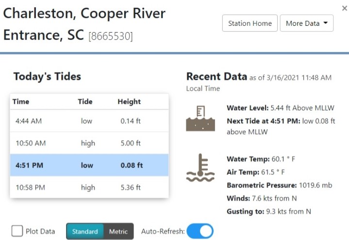
To determine the tidal range from this data subtract the highest water level (5.36 ft) from the lowest water level (0.08 ft). At this site, the tidal range is 5.28 ft.
Now, navigate to the locations listed below and determine the tidal range for these locations.
- Eastport, ME [8410140]
- Cape May, NJ [8536110]
- Virginia Key, Biscayne Bay, FL [8723214]
- Key West, FL [8724580]
- Galveston Bay Entrance, North Jetty, TX [8771341]
- San Francisco, CA [9414290]
- Neah Bay, WA [9443090]
- Anchorage, AK [9455920]
- On the Atlantic and Gulf of Mexico coastline of the US which of the above locations had the largest tidal range?
- On the Pacific coastline of the US which of the above locations had the largest tidal range?
Barrier Islands
Barrier islands are an especially important feature along the Atlantic coastline of the US. In these areas, there are abundant coastal sediments and low coastal relief (slope of the seafloor) due to the absence of recent coastal tectonic uplift. The Pacific coastline is an active margin and the very dynamic coastline features (rocky headlands and steep coastal relief) do not allow the formation of barrier islands. Watch the following video to learn more about barrier islands.
Exercise 7 – Barrier Islands
Answer the following questions:
- The barrier islands are described as having the following features:
- The barrier islands are separated from the mainland by the following features:
- During the Pleistocene (2.5 million to 11,700 years ago) the sea levels on Earth were higher than today. T/F
- A barrier island forms when a beach ridge (large sand dunes) is submerged by the rising sea levels. T/F
- Sand dunes are usually present on most barrier islands. What stabilizes these dunes?
- What type of sediment is present in the salt marsh?
- What is the longshore drift?
- For longshore drift to occur, waves approach the coastline in this pattern:
- What feature separates barrier islands?
- Wave energy is stronger during winter. T/F
- Overwash (or Washover) fans occur during the following events:
- Identify the correct sequence that occurs during coastal storms that cause overwash fans:
- Sea-level rise and repeated storms will cause barrier islands migration towards the mainland. T/F
In the figure below, NASA used imagery to measure the impact of coastal storms on the barrier islands of Louisiana.
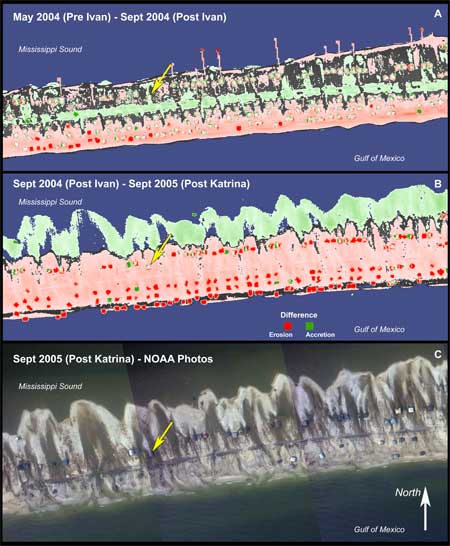
- What is happening to the barrier islands shown in the image?
- In what direction are the islands migrating?
- What caused the migrations to occur?
- Which storm caused more significant migration to occur?
Judging by what occurred along the Louisiana coast, Folly Beach and the other barrier islands near Charleston are likely to respond similarly in the event of a major coastal storm were to make landfall there. Click Google Earth Link for Folly Beach and explore this area. Take a closer look at the southwestern and northeastern ends of this barrier island and answer the following questions.
- Which of the following feature(s) can be identified near the island?
- Which erosional feature(s) can be identified in this map?
- Overwash fans are visible in these locations:
- In the long-term (100s to 1000s years range), in what direction will this island migrate?
