
Claire Chadwick; Lauren Maurizio; Robin Humphreys; and Vijay Vulava
Topography of Landscapes
Understanding stream behavior requires a good understanding of the topography of the region. Geologists use topographic maps to show topographyof an area. In the two videos below, the narrators describe different features to look for in a topographical map and how such maps can be used in practical settings.
Exercise 7 – Topographic Maps
Watch the videos for the following questions:
- What do the brown contour lines on the map represent?
- What is the contour interval of the map in the first video?
- What does the contour interval mean?
- What is an index contour?
- What is the difference in elevation between each index contour?
- Match the flat and steep areas in the topographic maps with the patterns in contour lines.
- On a topographic map, contour lines can touch or cross. T/F
Use this Crater Lake link to answer the questions below:
- Determine the approximate elevation of the Trailhead at the Rim Drive junction at the southern part of Crater Lake.
- Determine the approximate elevation of water in Crater Lake.
- Determine the approximate elevation of the rim of the crater on the Wizard Island inside the Crater Lake.
- Determine the contour interval near Crater Lake.
Exercise 8 – Topography of River Systems
Study the topography of the two river systems below. The first stream is the New River in West Virginia (and the site of our newest National Park!) and the second stream is the Saint Francis River in Arkansas. Click on the maps below to access detailed topographic maps.
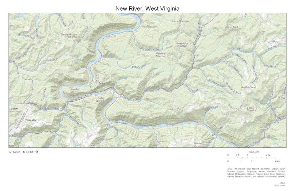
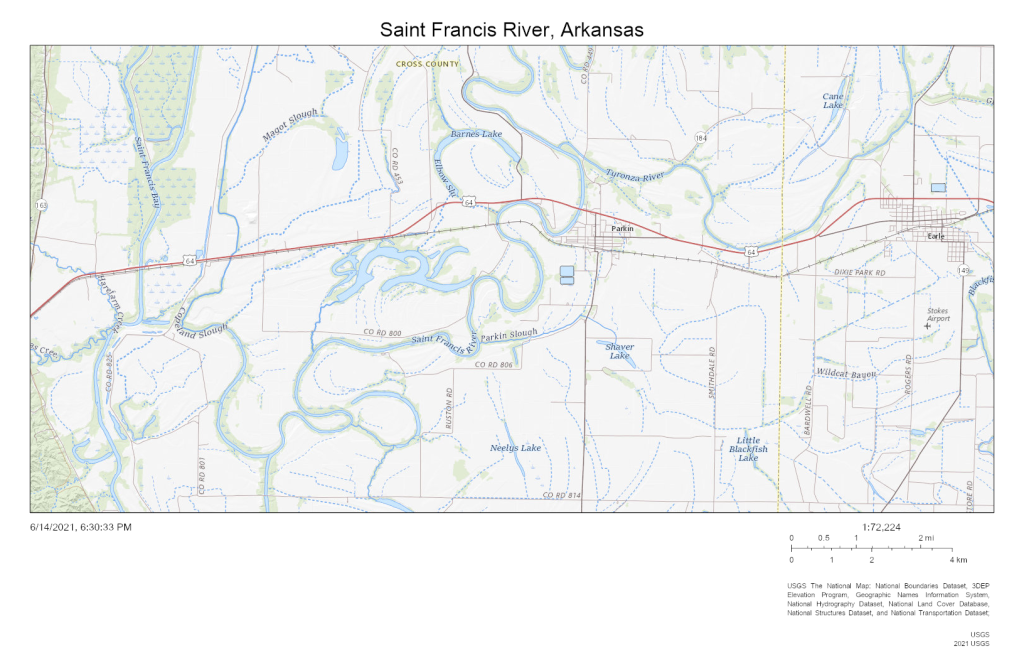
- Answer the following questions:
- Which of the two rivers, the New River or the Saint Francis River, has steeper topography within the floodplain?
- Explain your previous answer.
- Which of the two rivers, the New River or the Saint Francis River, can cause more erosion?
- Explain your previous answer.
- The approximate channel length (in miles) of the New River and the Saint Francis River. (Use the scale bar below the map to get a good estimate)
- The approximate straight-line length (in miles) of the New River and the Saint Francis River. (Use the scale bar below the map to get a good estimate)
- The approximate sinuosity (no units) of the New River and the Saint Francis River. (Divide Channel Length by Straight-line Length)
- The highest elevation (in feet) of the New River and the Saint Francis River.
- The lowest elevation (in feet) of the New River and the Saint Francis River.
- The vertical drop (in feet) of the New River and the Saint Francis River.
- The gradient (in ft/miles) of the New River and the Saint Francis River. (Divide Vertical Drop by Straight-Line Length)
- Which river has the steeper gradient?
- Which river has a more meandering channel?
- How are sinuosity and the gradient related?
- Which of the following river systems is likely to be an entrenched meander?
Changes in ground elevation.
