
Hurricanes (Tropical Cyclones)
Tropical cyclones (regionally known as hurricanes, typhoons, cyclones, etc.) are storms that originate in tropical ocean waters when the right conditions exist. These circulating systems contain a well-defined center and bands of high winds and rains and move from the open ocean onto land. Because of the energy they contain, these storms can cause enormous damage to life and property on land. Use the resources below to answer questions about hurricanes.
Exercise 1 – Hurricanes
Use the videos and the resources below to answer the following questions:
- Hurricanes | National Oceanic and Atmospheric Administration (noaa.gov)
- Module 5: Hurricane Formation and Evolution | Coastal Processes, Hazards, and Society (psu.edu)
- Hurricane information: Hurricanes: Science and Society: Home (hurricanescience.org)
- Hurricanes are categorized on the wind speed by this scale: Saffir-Simpson Hurricane Wind Scale (noaa.gov)
- What is a storm surge? (noaa.gov)
- Other types of damage that occur when hurricane make landfall: Hurricane Damage | UCAR Center for Science Education
- Where do hurricanes form?
- Hurricanes can occur at the equator. T/F
- What are at least three environmental conditions that cause a hurricane to form?
- What is the minimum water temperature for hurricane formation?
- On the Atlantic and the Gulf Coast of the US, where do hurricanes typically originate?
- In what direction do the circular pattern of winds blow the cluster of thunderstorm clouds?
- What phenomenon causes hurricanes in the northern hemisphere to spin in a counterclockwise direction?
- At what wind speed does an ocean storm is officially called a hurricane?
- What is the upper ceiling (in miles) of a hurricane? (Look up the height of the troposphere.)
- What is the calm low-pressure center of a hurricane called?
- Where do the strongest winds occur within the structure of a hurricane?
- How large an area can the wind field of a major hurricane influence?
- What two conditions cause hurricanes to lose strength?
- What is the name assigned to the hurricane wind speed?
- What is the name of the phenomenon that describes a higher than the tidal rise of water along coastlines as a hurricane makes landfall?
- List at least two other major types of damage caused by hurricanes.
- Of all the threats posed by hurricanes one of the following is the most significant threat to life and property.
Exercise 2 – Hurricane Hugo
Hurricane Hugo was a major hurricane that made landfall just north of Charleston, SC in 1989. This damaging hurricane not only resulted in the loss of life and major property and structural damage, but it also exposed the unpreparedness of our coast and the city to hurricane hazards. Use the information below to answer questions.
- National Weather Service site: Hurricane Hugo – September 21-22, 1989 (weather.gov).
- Use the USGS map to evaluate hazards.
- Additional information at HurricaneHugo1989.pdf (sc.gov).
- SC DNR created a Story Map of the disaster on the 30th anniversary.
- Where exactly did this hurricane make landfall?
- On the Saffir-Simpson scale, what was the category of this hurricane at landfall?
- In addition to the extreme winds, what were the main causes of damage to the coastal areas?
- The eye of the storm passed over the Charleston peninsula and this was estimated to have spared the area from the worst damage. Explain.
- How much rainfall fell in the Charleston area?
- How high was the storm surge in downtown Charleston?
- Using the (XY) elevation tool in the map link above determine if Randolph Hall might have been inundated during this storm surge.
- Are there locations within the Charleston peninsula that would not have been impacted?
Based on our knowledge of how hurricanes function, the location of a city or community north or south relative to the location of the landfall can influence how severe the impacts would be. Look at the image below that was produced using an NWS model that puts Hugo’s landfall to the south of Charleston at Kiawah Island.
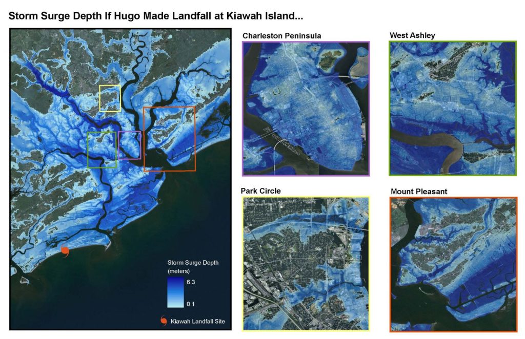
- Which location within the Charleston peninsula would not be impacted in this scenario?
- How will Folly Beach and the other barrier islands do in this scenario?
- Why is the landfall south of Charleston in this scenario bad for the Charleston area?
- Describe at least two ways we are better prepared now in terms of technology than in 1989.
Use the above video and or the links below to answer the questions.
- How many tropical storms have passed within 100 miles of cities of the world in the period between 1950-2016?
- According to SC DNR (click the link) how many hurricanes and tropical storms have made landfall along the SC coastline since records keeping began in 1852?
- According to NOAA, a major hurricane is a hurricane that is classified as Category 3 or higher. How many of the hurricanes that made landfall near SC since 1852 were major hurricanes?
- According to the IMF (International Monetary Fund), the GDP per capita in all storm-affected areas declined for several years. T/F
- According to NOAA, how many weather disasters exceeded $1 billion in damage?
- After many severe storms damage regions, the local economy can take many years before recovering fully. T/F
- List at least three ways economies suffer in the aftermath of storm damage.
- What global phenomenon is likely to make storms and storm-related damage worse?
- How can communities like Charleston prepare better to handle the storms?
