Claire Chadwick; Lauren Maurizio; Robin Humphreys; and Vijay Vulava
The Hanford Nuclear Site
In this section, we will focus on the history of groundwater contamination at the Hanford Nuclear site and assess if there is a danger to communities living downstream from this site. The Hanford Nuclear site in eastern Washington state on the banks of the Columbia River was the first plutonium processing plant in the world and was created during the second world war. Over the next several decades, they continued to produce plutonium for nuclear bombs before the eventual decommissioning bomb manufacturing. However, decades of operation left behind a legacy of highly contaminated groundwater, which includes dangerous levels of radionuclides and toxic chemicals. In this section, we will focus on the history of the site and the extent of groundwater contamination and assess if there is a danger to communities living downstream from this site. Use the information provided to learn more about the extent of the problem.
Watch the video at the link below. Take notes about the details and will be helpful for the questions below.
Exercise 6 – Hanford Site
Use the resources below to answer the following questions:
- The Site overview is provided by the WA Department of Ecology at https://bit.ly/3bxnetk.
- Wikipedia provides a great summary and additional details at https://bit.ly/3rrO8bD.
- Virtual tour of the B Reactor and the Hanford Site (look for it at left-most reactor adjacent to the Columbia River) where the first atomic bomb was manufactured: Hanford Virtual Tour
- The images below also provide additional information needed for your investigation.

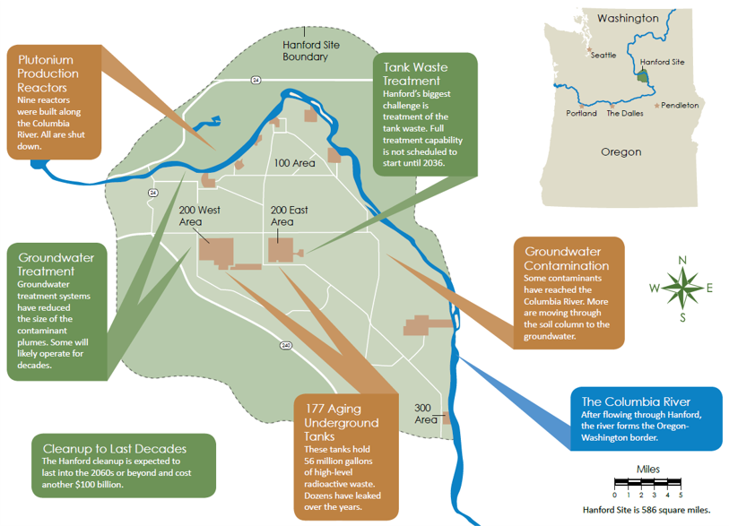
Figure 1: Map of the Hanford Site in the state of Washington. The Columbia River is shown flowing Northwest to Southeast on this Site, but the river originates in Canada in the Northeastern corner of the Washington State and flows to the Pacific Ocean to the West along the Oregon-Washington state line. The 100 Area is where all the plutonium processing and reactors are located. 
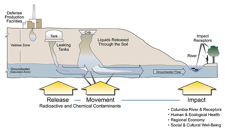
Figure 2: Pathways for contaminants to enter the groundwater and the subsequent discharge into the Columbia River. The contamination is present in the unconfined aquifer that is underlying this site. Source: https://bit.ly/3bxnetk. 
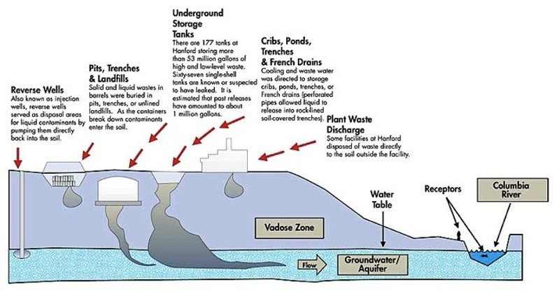
Figure 3: Details of various waste sources at the Hanford Site and the ongoing contamination of groundwater. Source: https://bit.ly/3rAE54e. 
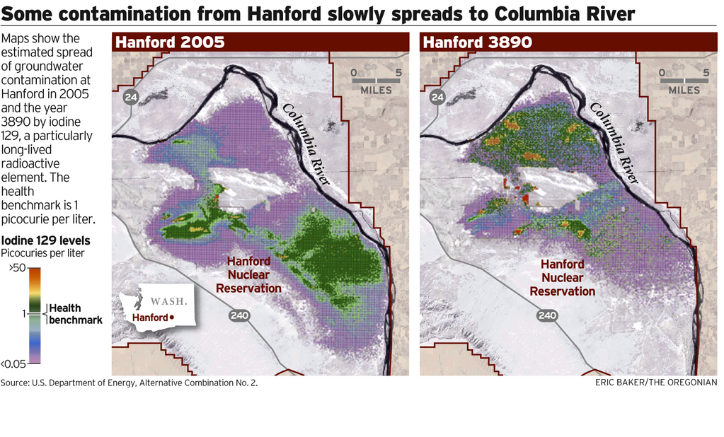
Figure 4: Plume of radioactive iodine in the groundwater below the Hanford Site in 2005. A groundwater model was used to predict where the plume will be in the year 3890. Source: https://bit.ly/2PN7YQK.
- Where is the Hanford Site located?
- How large is this site in the area?
- What was the main reason this site was created?
- Which major river is located next to the Hanford Site?
- When did the operations begin at the Hanford Site?
- The Hanford Site is still producing plutonium. T/F
- According to the video, how much waste was discharged into the soils at this site?
- Identify four radioactive elements that leaked from the underground storage tanks into the groundwater.
- Identify the two toxic chemicals (not radioactive elements) that leaked from the underground storage tanks into the groundwater.
- The extent of groundwater contamination at the site is decreasing. T/F
- Explain the reason for this.
- According to the Department of Energy (the video producer), groundwater contamination is not a threat to the Columbia River. T/F
- What is your opinion based on what you learned so far?
- There is a significant groundwater contaminant plume in the center of the site. What is the name of the method being employed to clean up the contaminated groundwater?
- How much groundwater has been cleaned up at the time of this video production?
- How much high-level waste was stored in the underground storage tanks?
- What is the primary pathway from these leaking tanks to the Columbia River?
- How much is the site cleanup expected to cost?
- Using the small map overview in the upper right corner of Figure 1, cities (The Dalles, Portland, etc.) that are downstream of this site are at risk. T/F
- Explain your answer.
- Figure 4 shows the plume of iodine-129 (a long-lived radioactive element) into the year 3890. Is a decline in groundwater contamination expected?
- Explain your answer.

