
10.2 Earthquakes and Plate Tectonics
Plate boundaries were originally drawn with data from earthquakes! All tectonic boundaries have earthquakes associated with them, though they vary in size and frequency. The distribution and depth of earthquakes across the globe is shown in Figure 10.2.1. It is relatively easy to see the relationships between earthquakes and plate boundaries.

Earthquakes are also relatively common at a few intraplate (within a tectonic plate) locations. Some are related to human activities, such as mining or oil fracking. Others occur naturally and are related to the buildup of stress due to continental rifting or the transfer of stress from other regions. Yellowstone National Park, located in the northwest United States, is an example of a place that experiences earthquakes within a tectonic plate. Located hundreds of miles from a plate boundary, over 48,000 earthquakes have been recorded in the park since 1973, though most are very small and not noticeable to people (2).
Most earthquakes occur at plate boundaries, though their sizes, locations, and frequency vary. The figure above not only shows the location of earthquakes, but it shows their depths. Along divergent boundaries, like the mid-Atlantic ridge and the East Pacific Rise, earthquakes are common, but in a narrow zone at shallow depth. Shallow earthquakes are also common along transform boundaries, such as the San Andreas Fault. Of course earthquakes also occur at convergent boundaries, whether they involve continental or oceanic crust. Along subduction zones, as oceanic crust descends, earthquakes are very abundant. The subducting slab causes a much broader zone of earthquakes and at greater depth in the crust than other plate boundaries.
Earthquakes at Divergent Boundaries
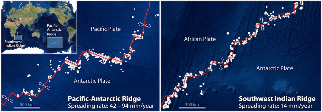
Divergent boundaries are usually found in oceanic crust, like the Mid-Atlantic Ridge. Some earthquakes do occur on spreading ridges, but they tend to be small and infrequent because of the relatively high rock temperatures in the areas where spreading is taking place. Though the mechanism of plate tectonics at this boundary causes large scale spreading, transform faults often link the diverging segments, and it is there that the majority of earthquakes occur. Figure 10.2.2 provides a closer look at magnitude (M) 4 and larger earthquakes in an area of divergent boundaries in the mid-Atlantic region near the equator. The spreading segments of the mid-Atlantic ridge are offset by some long transform faults. Most of the earthquakes are located along the transform faults, rather than along the spreading segments, although there are clusters of earthquakes at some of the ridge-transform boundaries.
Earthquakes at Transform Boundaries
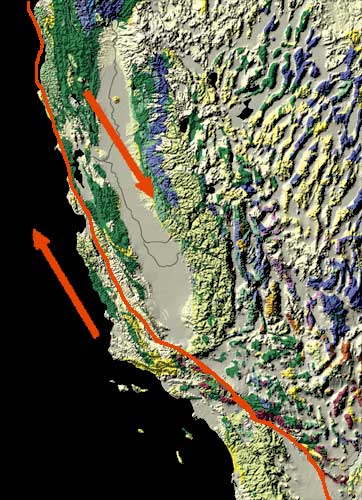
As previously discussed, transform boundaries generate many earthquakes as the tectonic plates slide by each other. Transform boundaries tend to have steeper rupture surfaces, which cause the earthquakes to occur in a narrow zone and limits their size. The largest earthquakes on transform boundaries are in the order of a magnitude (M) 8. The most well known transform fault in North America is the mighty San Andreas Fault, located between the North American and Pacific plates. Figure 10.2.3 shows this boundary. At this scale, the fault appears to be a single line, but it is actually an intricate network of smaller faults. Thousands of earthquakes occur along this fault every year, but major events happen every 100-150 years. Using this calculation, the southern portion of the San Andreas is more likely to produce a large earthquake, because the last major event was in 1857, whereas the northern portion had a major earthquake in 1906.
Earthquakes at Convergent Boundaries
Many earthquakes, both large and small, occur at convergent boundaries. The pattern and distribution of the earthquakes is related to the type of crust involved. Whether continental or oceanic crust is converging, the largest earthquakes occur at these boundaries.
Subduction Zones
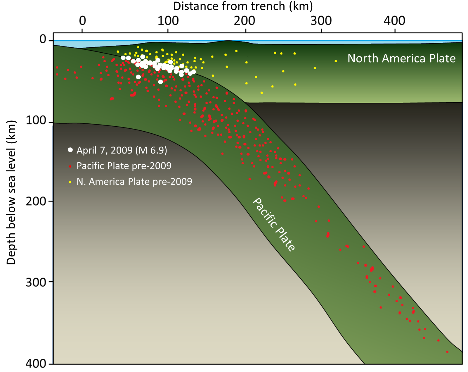
Subduction zones occur where ocean-ocean and ocean-continent plates collide, and oceanic crust is subducted beneath an overriding plate. In the figure below, convergence occurs between the continental crust on the North America Plate and the oceanic crust of the Cocos Plate. At boundaries like these, the earthquakes occur on the continental crust and get deeper with distance from the trench. In Figure 10.2.4 below, all types of plate boundaries are shown. As you can see, earthquake activity is related to plate boundaries with the least occurring where plates are pulling away.

Continent-Continent Convergence
The most famous example of continent-continent convergence is at the India-Eurasia plate boundary, shown in Figure 10.2.6 below. Initially, subduction took place at this boundary, but today the India Plate continues to push into the Eurasia Plate with no actual subduction taking place. There are transform faults on either side of the India Plate in this area as well.

The entire northern India and southern Asia region is very seismically active. Earthquakes are common in northern India, Nepal, Bhutan, Bangladesh and adjacent parts of China, and throughout Pakistan and Afghanistan. While many of the earthquakes are related to the transform faults on either side of the India Plate, most of the others are related to the significant tectonic squeezing caused by the continued convergence of the India and Asia Plates. That squeezing has caused the Asia Plate to be thrust over top of the India Plate, building the Himalayas and the Tibet Plateau to enormous heights. These types of faults, where continental crust ramps up over adjacent continental crust are called thrust faults. Hundreds more earthquakes occur at this boundary than are drawn on the figure, but they cannot be seen at this scale. (1)

The schematic above (Fig. 10.2.7) shows the thrust faults and rock types that are found at the Himalayas. Notice that the boundary is also not volcanic, because subduction is no longer occurring. The top of the Himalayan mountains, the highest elevation on the Earth’s surface, is comprised of sedimentary rocks!
Human-Induced Earthquakes
Can humans create earthquakes? Not intentionally, but the answer is yes, and here is why. If a water reservoir is built on top of an active fault line, the water may lubricate the fault and weaken the stress built up within it. This may either create a series of small earthquakes or potentially create a massive earthquake. Also, the sheer weight of the reservoir r’s water can weaken the bedrock causing it to fracture. Then the obvious concern is if the dam fails. Earthquakes can also be generated if humans inject other fluids into a fault, such as sewage or chemical waste. Finally, nuclear explosions can trigger earthquakes. One way to determine if a nation has tested a nuclear bomb is by monitoring the earthquakes and energy released by the explosion (3).
Backyard Geology: Earthquakes in Arizona
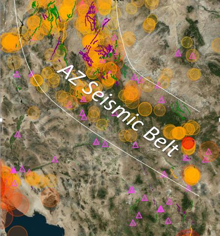
Arizona has a very active history of earthquakes along fault lines. Because most of them are smaller and occur deep within the crust, very few of them actually rupture the surface. There has only been 1 earthquake greater than an M7 in recorded history. While there is no plate boundary currently associated with Arizona, there are remnants of subducted crust that was thrust beneath the North American plate up to approximately 35 million years ago. Most, therefore occur in a linear zone across AZ, referred to as a seismic belt (Figure 10.2.8)
***See 10.6 for Text and Media Attributions
A region along Earth's lithosphere where at least two tectonic plates move apart from one another.
A region along Earth's lithosphere where at least two tectonic plates slide past one another.
A region along Earth's lithosphere where at least two tectonic plates collide with one another.
when one tectonic plate slides beneath another
size
Thick crustal material mostly made of feldspar and silica rich minerals which forms the world's large landmasses.
A type of rigid, thin crust made of iron and magnesium rich minerals that is found beneath the planet's oceans.
The process in which the older, denser tectonic plate at a convergent boundary will buckle and sink into the lithosphere. This plate will always be composed of oceanic lithosphere.
