
13 7.3 Plate Tectonics and Regional Metamorphism
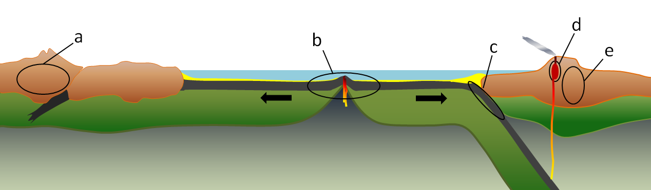
All of the important processes of metamorphism that we are familiar with can be understood in the context of geological processes related to plate tectonics. The relationships between plate tectonics and metamorphism are summarized in Figure 7.3.1, and in more detail in Figures 7.3.2, 7.3.3, 7.3.4, and 7.3.6.
Regional Metamorphism
Regional metamorphism affects rocks over an extensive area as a result of the large-scale action of heat and pressure. Due to the type of pressure needed, this typically occurs at plate boundaries. The result is foliated rocks due to the differential pressures applied at these boundaries.
Continental-Continental Convergence
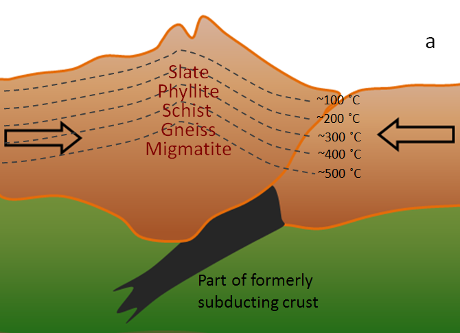
Most regional metamorphism takes place within the continental crust. While rocks can be metamorphosed at depth in most areas, the potential for metamorphism is greatest in the roots of mountain ranges where there is a strong likelihood for burial of relatively young sedimentary rock to great depths, as depicted in Figure 7.3.2. An example would be the Himalayan Range. At this continent-continent convergent boundary, sedimentary rocks have been both thrust up to great heights (nearly 9,000 meters above sea level) and also buried to great depths. Considering that the normal geothermal gradient (the rate of increase in temperature with depth) is around 30°C per kilometer, rock buried to 9 kilometers below sea level in this situation could be close to 18 kilometers below the surface of the ground, and it is reasonable to expect temperatures up to 500°C. Metamorphic rocks formed there are likely to be foliated because of the strong directional pressure (compression) of converging plates.
Oceanic Divergence
At an oceanic spreading ridge, recently formed oceanic crust of gabbro and basalt is slowly moving away from the plate boundary (Figure 7.3.3). Water within the crust is forced to rise in the area close to the source of volcanic heat, and this draws more water in from farther out, which eventually creates a convective system where cold seawater is drawn into the crust and then out again onto the sea floor near the ridge. The passage of this water through the oceanic crust at 200° to 300°C promotes metamorphic reactions that change the original pyroxene in the rock to chlorite and serpentine. Because this metamorphism takes place at temperatures well below the temperature at which the rock originally formed (~1200°C), it is known as retrograde metamorphism. The rock that forms in this way is known as greenstone if it isn’t foliated, or greenschist if it is. Chlorite ((Mg5Al)(AlSi3)O10(OH)8) and serpentine ((Mg, Fe)3Si2O5(OH)4) are both “hydrated minerals” meaning that they have water (as OH) in their chemical formulas. When metamorphosed ocean crust is later subducted, the chlorite and serpentine are converted into new non-hydrous minerals (e.g., garnet and pyroxene) and the water that is released migrates into the overlying mantle, where it contributes to flux melting.

Continental-Oceanic Convergence
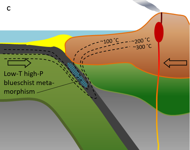
At a subduction zone, oceanic crust is forced down into the hot mantle. But because the oceanic crust is now relatively cool, especially along its sea-floor upper surface, it does not heat up quickly, and the subducting rock remains several hundreds of degrees cooler than the surrounding mantle (Figure 7.3.4). A special type of metamorphism takes place under these very high-pressure but relatively low-temperature conditions, producing an amphibole mineral known as glaucophane (Na2(Mg3Al2)Si8O22(OH)2), which is blue in color, and is an important component of a rock known as blueschist.
You’ve probably never seen or even heard of blueschist; that’s not surprising. What is a little surprising is that anyone has seen it! Most blueschist forms in subduction zones, continues to be subducted, turns into eclogite at about 35 kilometers depth, and then eventually sinks deep into the mantle—never to be seen again because that rock will eventually melt. In only a few places in the world, where the subduction process has been interrupted by some other tectonic process, has partially subducted blueschist rock returned to the surface. One such place is the area around San Francisco; the rock is known as the Franciscan Complex (Figure 7.3.5).

Contact Metamorphism
Magma is produced at convergent boundaries and rises toward the surface, where it can form magma bodies in the upper part of the crust. Such magma bodies, at temperatures of around 1000°C, heat up the surrounding rock, leading to contact metamorphism (Figure 7.3.6). Because this happens at relatively shallow depths, in the absence of directed pressure, the resulting rock does not normally develop foliation. The zone of contact metamorphism around an intrusion is very small (typically meters to tens of meters) compared with the extent of regional metamorphism in other settings (tens of thousands of square kilometers).
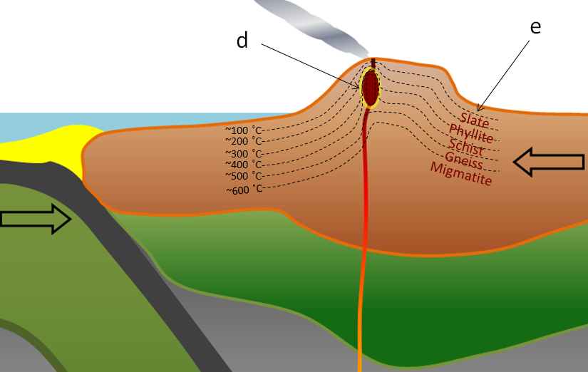
Regional metamorphism also takes place within volcanic-arc mountain ranges, and because of the extra heat associated with the volcanism, the geothermal gradient is typically a little steeper in these settings (somewhere between 40° and 50°C per kilometer). As a result higher grades of metamorphism can take place closer to surface than is the case in other areas (Figure 7.3.6).
Geothermal Gradient
Another way to understand metamorphism is by using a diagram that shows temperature on one axis and depth—which is equivalent to pressure—on the other (Figure 7.3.7). The three heavy dotted lines on this diagram represent Earth’s geothermal gradients under different conditions. In most areas, the rate of increase in temperature with depth is 30°C per kilometer. In other words, if you go 1,000 meters down into a mine, the temperature will be roughly 30°C warmer than the average temperature at the surface. In most parts of southern Canada, the average surface temperature is about 10°C, so at a 1,000 meter depth, it will be about 40°C. That’s uncomfortably hot, so deep mines must have effective ventilation systems. This typical geothermal gradient is shown by the green dotted line in Figure 7.3.7. At a 10 kilometer depth, the temperature is about 300°C and at 20 kilometers it’s about 600°C.
In volcanic areas, the geothermal gradient is more like 40° to 50°C per kilometer, so the temperature at a 10 kilometer depth is in the 400° to 500°C range. Along subduction zones, as described above, the cold oceanic crust keeps temperatures low, so the gradient is typically less than 10°C per kilometer. The various types of metamorphism described above are represented in Figure 7.3.7 with the same letters (a through e) used in Figures 7.3.1 to 7.3.4 and 7.3.6.
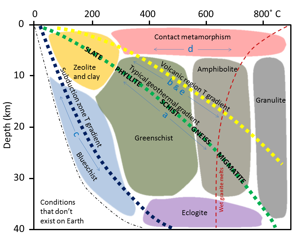
By way of example, if we look at regional metamorphism in areas with typical geothermal gradients, we can see that burial in the 5 kilometer to 10 kilometer range puts us in the zeolite and clay mineral zone (see Figure 7.3.7), which is equivalent to the formation of slate. At 10 to 15 kilometers, we are in the greenschist zone (where chlorite would form in mafic volcanic rock) and very fine micas form in mudrock, to produce phyllite. At 15 to 20 kilometers, larger micas form to produce schist, and at 20 to 25 kilometers amphibole, feldspar, and quartz form to produce gneiss. Beyond a depth of 25 kilometers in this setting, we cross the partial melting line for granite (or gneiss) with water present, and so we can expect migmatite to form.
Index Minerals
As previously described, regional metamorphism occurs when rocks are buried deep in the crust. This is commonly associated with convergent plate boundaries and the formation of mountain ranges. Because burial to 10 to 20 kilometers is required, the areas affected tend to be large—thousands of square kilometers.
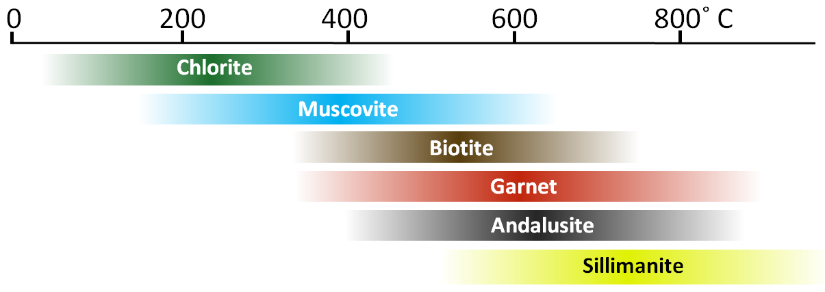
Rather than focusing on metamorphic rock textures (slate, schist, gneiss, etc.), geologists tend to look at specific minerals within the rocks that are indicative of different grades of metamorphism, called index minerals. Some common index minerals in metamorphic rocks are shown in Figure 7.3.8, arranged in order of the temperature ranges over which they tend to be stable. The upper and lower limits of the ranges are intentionally vague because these limits depend on a number of different factors, such as the pressure, the amount of water present, and the overall composition of the rock.
***See 7.6 for Text and Media Attributions
the mineralogical adjustment of relatively high-grade metamorphic rocks to temperatures lower than those of their initial metamorphism
forms when oceanic crust rubs against the overriding plate as it subducts at a subduction zone.
metamorphic rocks that formed under the lowest temperatures and pressures usually produced by regional metamorphism, typically 300–450 °C (570–840 °F) and 2–10 kilobars (14,500–58,000 psi)
a process in which solid rock melts because volatiles such as water vapor have caused its melting point to decrease.
silicate minerals that typically form during low-grade metamorphism of volcanic rocks.
