
2.9 The Great Cycle
Our world map has inspired human imagination for centuries. Alfred Wegener was not the first to notice that the South American and African coastlines could align together like puzzle pieces or conclude that they might have once been connected as one mass. However, in his book over a century ago, Wegener was the first to publish the words “Ur-Kontinent” and “Pangäa”, which we now popularly refer to as a supercontinent or Pangaea today.
When the ideas of seafloor spreading and continental drift were unified into the theory of plate tectonics by J. Tuzo Wilson in the late 1960s, questions remained over how Earth’s appearance evolved over its 4.54 billion-year history. If the oceans and continents did shift and change configuration as a result of tectonic forces, then what might our world map look like millions or billions of years ago, or even, in the future?
In the decades following the acceptance of plate tectonics until present, geologists have examined the rock and fossil record for clues to describe the appearance of Earth throughout the eons. Many of these techniques were similar to those used by Alfred Wegener, Marie Tharp, and Harry Hess. Today, there are still many questions about the processes behind plate tectonics and Earth’s history, but we have pieced together paleomaps that illustrate Earth’s past appearance.
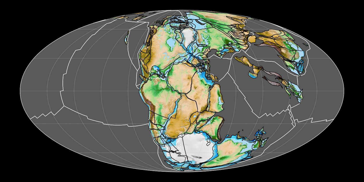
Throughout Earth’s history, there have been several episodes of supercontinent assembly and breakup. The last supercontinent on Earth was called Pangaea, and it existed around 300 million to 180 million years ago. The formation of a supercontinent is driven by convergent boundaries. However, the breakup of these landmasses requires a more complicated mechanism. The extremely thick crust from the convergence of land will insulate the lithosphere and eventually allow magma to rise from the mantle; thus, divergent boundaries will form throughout the supercontinent. It took approximately 250 million years for our world map to arrive at its current, broken-up, configuration from Pangaea.
The pattern of tectonic forces causing supercontinents to form, breakup, then form once more is called the Wilson Cycle (named for J. Tuzo Wilson). This cycle has been operating for at least a billion years; before Pangaea, a supercontinent called Rodinia had assembled around 1 billion years ago. Current modeling suggests that the Wilson Cycle will continue well into the future. Hundreds of millions of years in the future – about 250 million to be precise – a new supercontinent will form on Earth. We are currently referring to it as “Pangaea Proxima” or “Pangaea Ultima”
All of this demonstrates that our planet has been undergoing a tremendous cycle that continuously reshapes its surface over billions of years, and we are just beginning to understand this process!
***See 2.10 for Text and Media Attributions
a massive landmass composed of multiple continents formed by the collision of tectonic plates with smaller continents.
also known as Pangea. A large, single landmass, or supercontinent, that existed on Earth from about 300 - 180 million years ago.
A process of oceanic crust creation at mid-ocean ridges in which magma rises from the mantle, cools, and pushes existing rock at the ridge outward.
A hypothesis that claims the Earth's landforms, specifically continents, move across the oceans over tens of millions of years.
The theory that the outer layer of the Earth (the lithosphere) is broken in several plates, and these plates move relative to one another, causing the major topographic features of Earth (e.g. mountains, oceans) and most earthquakes and volcanoes.
A region along Earth's lithosphere where at least two tectonic plates collide with one another.
The outer, relatively rigid layer of the Earth that responds to the emplacement of a load by flexural bending.
molten rock that can be found beneath the Earth's surface.
A hot interior layer of solid rock between the crust and core that is capable of plastic flow. The mantle is the largest layer of Earth.
A region along Earth's lithosphere where at least two tectonic plates move apart from one another.
The recurring pattern of tectonic forces causing continents to collide into supercontinents and break apart over hundreds of millions of years.
