
9.4 Measuring Geological Structures
Geologists take great pains to measure and record geological structures because they are critically important to understanding the geological history of a region. One of the key features to measure is the orientation, or attitude, of bedding. We know that sedimentary beds are deposited in horizontal layers, so if the layers are no longer horizontal, then we can infer that they have been affected by tectonic forces and have become either tilted, or folded. We can express the orientation of a bed (or any other planar feature) with two values: first, the compass orientation of a horizontal line on the surface—the strike—and second, the angle at which the surface dips below a horizontal plane, (perpendicular to the strike)—the dip (Figure 9.4.1).
It may help to imagine a vertical surface, such as a wall in your house. The strike is the compass orientation of the wall and the dip is 90˚ from horizontal. If you could push the wall so it’s leaning over, but still attached to the floor, the strike direction would be the same, but the dip angle would be less than 90˚. If you pushed the wall over completely so it was lying on the floor, it would no longer have a strike direction and its dip would be 0˚. When describing the dip it is important to include the direction. In other words. if the strike is 0˚ (i.e., north) and the dip is 30˚, it would be necessary to say “to the west” or “to the east.” Similarly if the strike is 45˚ (i.e., northeast) and the dip is 60˚, it would be necessary to say “to the northwest” or “to the southeast.”

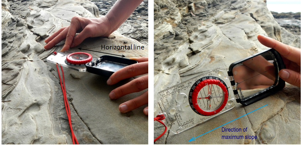
Measurement of geological features is done with a special compass that has a built-in clinometer—a device for measuring vertical angles. An example of how this is done is shown on Figure 9.4.2.
Strike and dip are also used to describe any other planar features, including joints, faults, dikes, sills, and even the foliation planes in metamorphic rocks. Figure 9.4.3 shows an example of how we would depict the beds that make up an anticline on a map.
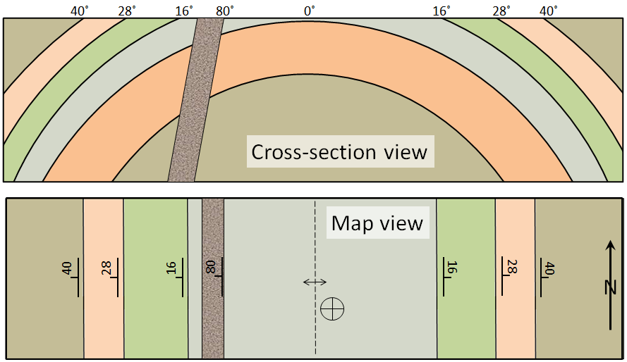
The beds on the west (left) side of the map are dipping at various angles to the west. The beds on the east side are dipping to the east. The middle bed (light grey) is horizontal; this is denoted by a cross within a circle. The dike is dipping at 80˚ to the west. The hinge of the fold is denoted with a dashed line with two arrows that point away from it. If it was a synform, the arrows would point towards the line.
***See 9.5 for Text and Media Attributions
direction of the line formed by the intersection of a fault, bed, or other planar feature and a horizontal plane
the angle at which a planar feature is inclined from the horizontal plane.
