5.2 Volcano Shape
Types of Volcanoes
There are all types of volcanoes on our planet: some are huge, some are no bigger than hills, some are explosive, and some are less so. There are several broad types of volcanoes based on their shape, eruption style, magma composition, and other aspects. However, all volcanoes should be regarded as potentially deadly!
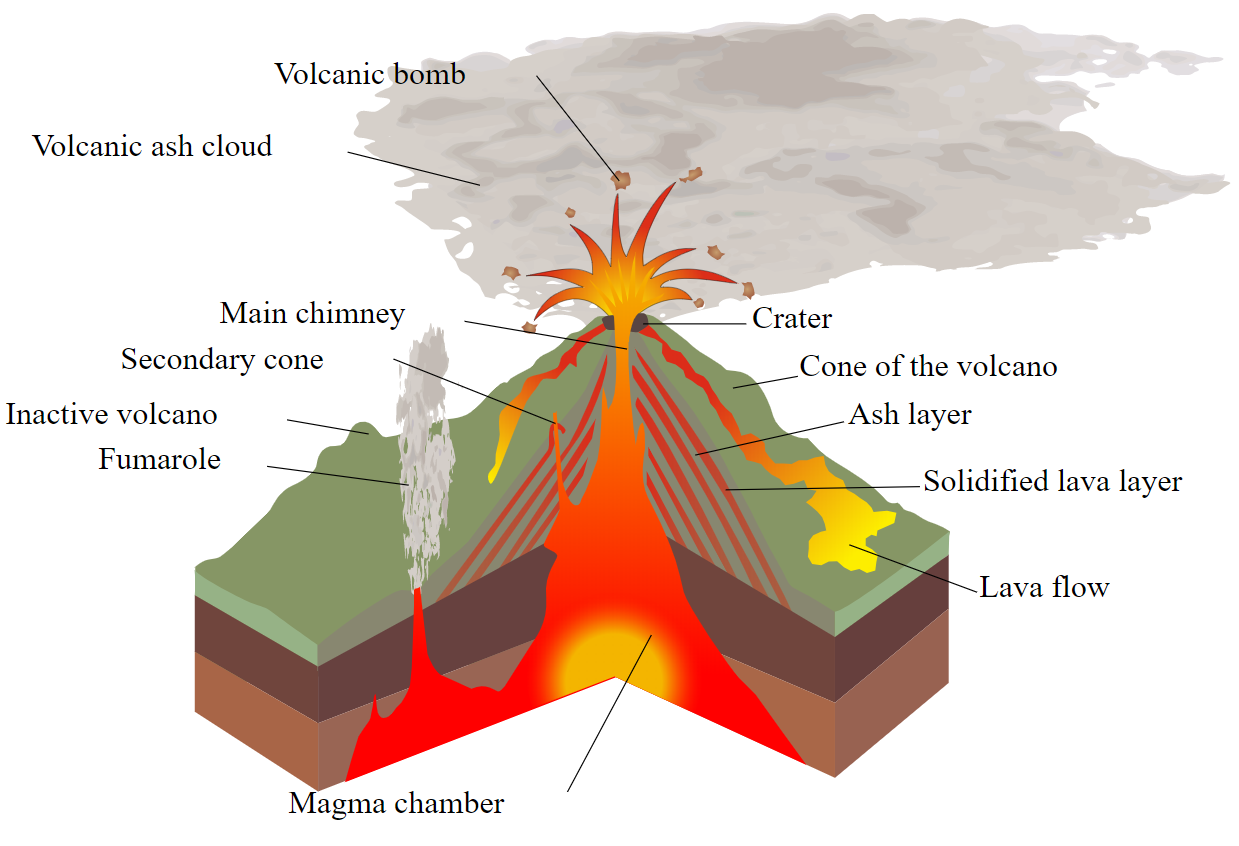
Volcanoes have a cone-shaped structure that has been built over long periods of geologic time after multiple eruptions. At the very top of this cone is a crater. All active volcanoes sit atop a plume of magma called a magma chamber. The composition of this magma can vary from felsic to mafic depending on factors such as region, overlying crust composition, and tectonic setting.
When the magma chamber experiences too much pressure, it will erupt. The molten rock and volatile gases explode upward through a pipe-like column called a chimney. When the magma reaches the surface, it is called lava, even though the composition does not change.
Magma chambers, cones, craters, chimneys, and lava are features that are diagnostic of volcanoes. However, that is where the similarities end. Below, we will explore the different types of volcanoes on our planet.
Cinder Cones
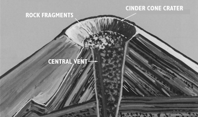
Cinder cones are small volcanoes with steep sides, made of tephra and volcanic bombs ejected from a clear central vent. Cinders themselves are composed primarily of mafic lava with more volatile gases than average. Cinders are smaller pieces of tephra, or molten rock, that will erupt with lava from the volcano and rapidly cool and solidify in the air. Larger tephra rocks (over 2.5 inches) are called volcanic bombs, which are potentially deadly to anyone within range.
Cinder cone volcanoes do not last relatively long, but they are common in the United States and Mexico. Because they are usually mafic in composition, they produce extrusive igneous rock deposits such as scoria.
Lava Domes

Lava Domes are fairly small structures made of felsic rocks that form within the collapsed craters of stratovolcanoes. These domes are made of extrusive rocks such as rhyolite, pumice, and obsidian that are piled around the vent. The dome-like structure is the result of the high-viscosity of the felsic to intermediate lava, which is too sticky to move long distances.
Lava domes have appeared in Mount St. Helens, Mammoth Mountain in California, and Chaiten in Chile (see above image).
Stratovolcanoes
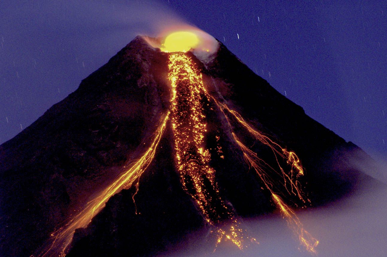
Mount St. Helens, Mount Vesuvius, Mount Fuji, Mount Pinatubo, Krakatoa—all of these infamous volcanoes belong to a frightening class of volcanoes that are historically known for their destruction and hazards. Stratovolcanoes (also called composite volcanoes) have steep sides and a symmetrical cone shape with an easily identifiable crater on top. These are called “composite” or “strato” because of the different layers of volcanic materials (such as ash) and lava that build up the volcano [1].
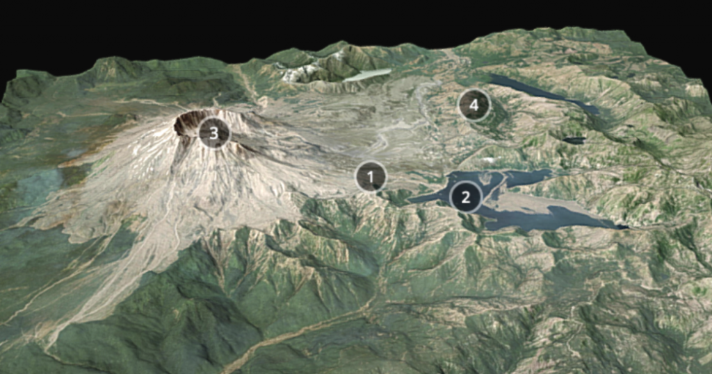
Stratovolcanoes can have magma that is anywhere from felsic to mafic in composition, although most of these volcanoes tend to be intermediate in composition. Stratovolcanoes usually form along subduction zones between oceanic-oceanic or continental-oceanic lithosphere. A good example of these volcanoes can be found along the Pacific Northwest. There, an ancient subduction zone used to exist between the North American plate and Farallon plate which formed the Cascade Mountain range and deadly stratovolcanoes including Mount Rainier and Mount St Helens. Check out the interactive model of Mt St Helens, below
Shield Volcanoes
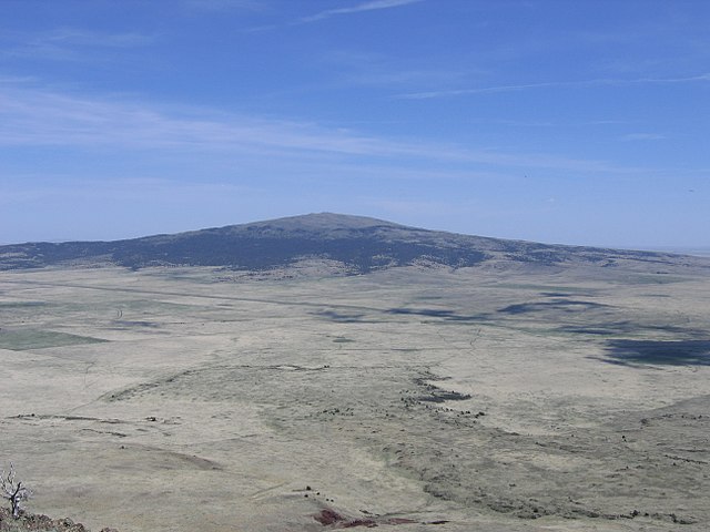
The largest type of volcano is a shield volcano. These are characterized by very broad, shallow slopes, and small vents. The word “shield” refers to the shield-like shape of the volcano when it is viewed from the side. Shield volcanoes are sourced from low-viscosity mafic magma, and they typically have basaltic lava that has reached far distances along the volcanic slope. We typically observe shield volcanoes in areas where the upper mantle rises to meet the crust. These areas include hot spots, mid-ocean ridges, and continental rift zones.
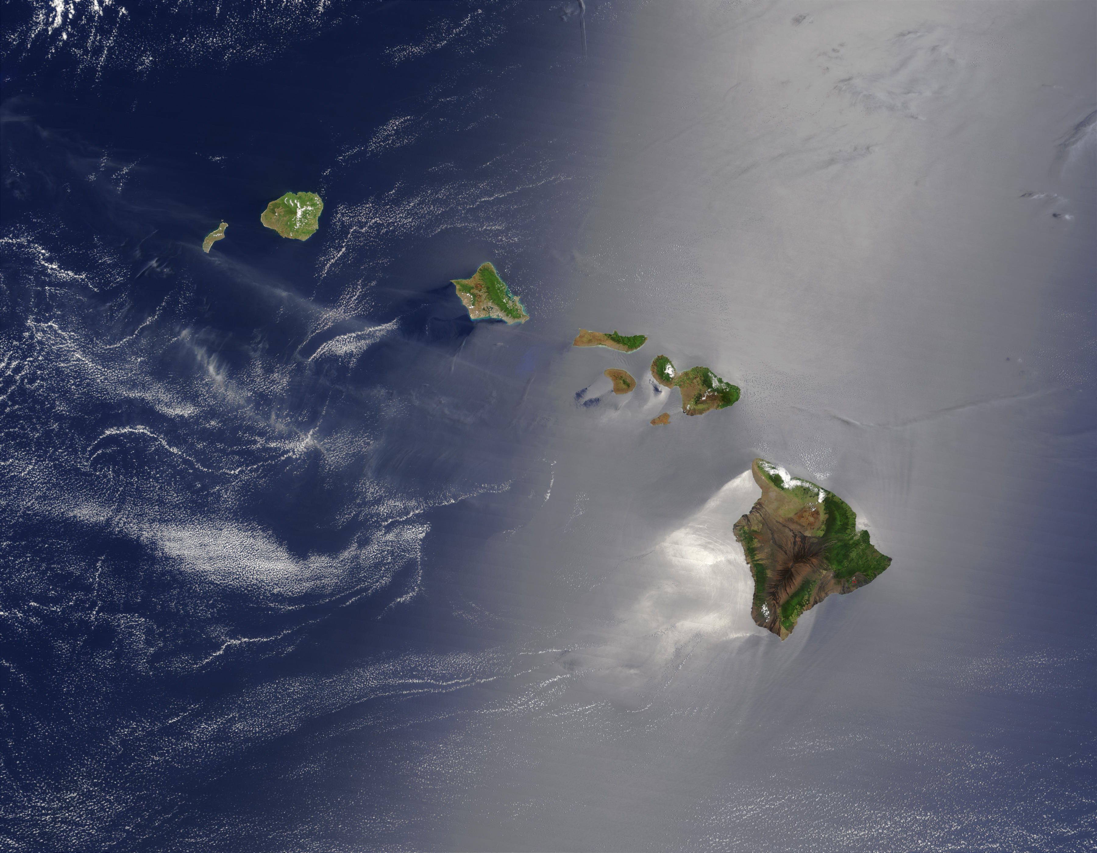
The mafic magma below shield volcanoes does not contain too many volatile gases; therefore, when shield volcanoes erupt, they are not very explosive. Instead, these volcanic eruptions are fairly small and predictable, which makes them less of a potential hazard than others. A perfect example of shield volcanoes can be found with the Hawaiian Islands at Mauna Loa and Kilauea (right). Click here to view an interactive model of Mauna Loa, the world’s largest shield volcano!
Kilauea is the most active volcano in the world, although it does not cause many human fatalities. The eruption of Kilauea from fissures in Hawaii in 2018, however, produced lavas that did considerable damage to roads and structures [1].
Backyard Geology: House Mountain, Sedona 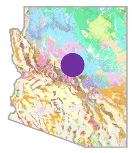
Sedona, AZ is not just a resort town with rust-red rocks! About 15 million years ago, this region was volcanically active due to the migrating continental hot spot, which is responsible for the San Francisco Volcanic Field. This hot spot produced both mafic magmas and lavas and near Sedona, a large shield volcano formed that we now call “House Mountain”. House mountain is pretty huge! This large shield volcano covers the area around 84 smaller volcano vents in an area of 180 square miles. While that is still much smaller than Mauna Loa (2,035 square miles!), that is still a pretty huge volcano [2]!
Calderas

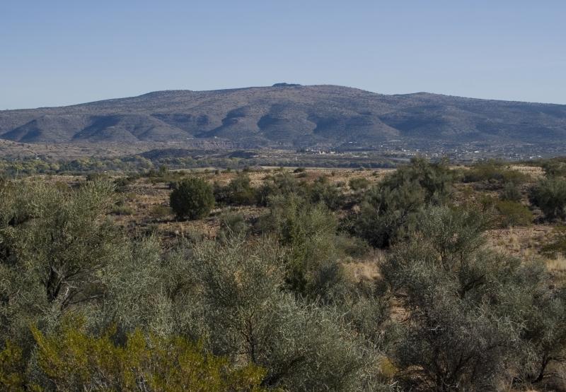
Calderas are large (up to 15 miles in diameter!), crater-like depressions that form after a volcano has collapsed after it has emptied much of its magma chamber. It takes a very explosive eruption to eventually form a caldera, so it should come as no surprise that most calderas are found at volcanoes with highly viscous felsic and intermediate magma.
Because the caldera is a basin or depression, it often is filled-in by water to become a crater-lake. The Yellowstone Caldera and Crater Lake, Oregon (above) is a notable example of this type of volcano. In the figure below, you can see a diagram of how a caldera forms at Crater Lake from the Mount Mazama stratovolcano [1]. This volcano has an explosive eruption that drains the magma chamber, and causes a collapse of the vent. That collapsed feature then fills with water.
Flood Basalts
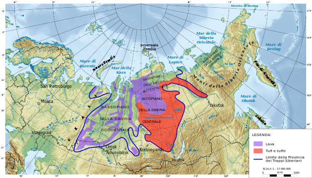
Flood basalts are a very uncommon type of eruption, but they are by far the largest and longest. As the name suggests, Flood Basalts are large-scale eruptions of basaltic lava. We have not seen flood basalts throughout human history, but the evidence of flood basalt activity has been found in the geologic record. We currently estimate that once volcanism begins, flood basalts will erupt for up to 1-3 million years!
Some notable examples of flood basalts include the Deccan Traps that cover about one-third of India and the Siberian Traps, which can be found in Russia. We now think that flood basalt volcanism can be a key contributor in causing mass extinctions in our planet’s history. For instance, the Siberian Traps, which were active about 252 million years ago, may have expelled greenhouse gases into the atmosphere in such large amounts that the entire planet’s temperature could have rapidly increased by 5°C!
This process of rapid warming in combination with other factors may have caused the largest mass extinction the world ever experienced, the Permian-Triassic Mass Extinction.
Super Volcanoes
“Super-volcanic” eruptions have the ability to impact the entire planet, and the life inhabiting it, for years. The eruption can exceed 100,000 atomic bombs! For those lucky enough to survive the initial blast, massive amount of ash is also ejected into the atmosphere and will blanket land hundreds of kilometers away. The combination of toxic gases and ash will furthermore block out sunlight in the atmosphere and cause “volcanic winters” that last for years. Such devastating eruption have not yet occurred in modern human society…yet.
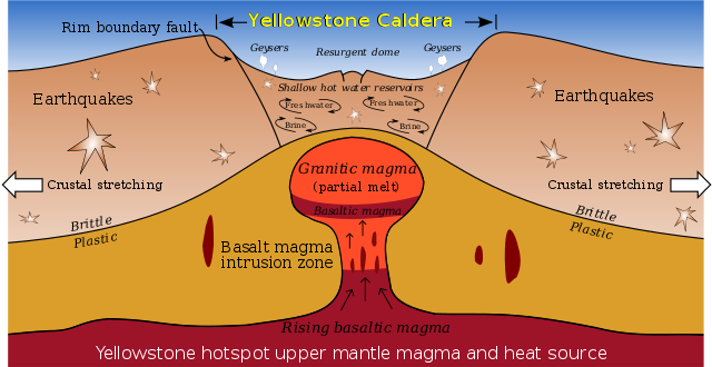
The Yellowstone Hot Spot is an active caldera-type volcano that is capable of a super-volcanic eruption. Although this is a hot spot volcano, it is very different from the shield volcanoes of Hawaii! This is because Yellowstone is located on the continental plate of North America. This very thick plate produces felsic to intermediate magma, which will erupt very violently.
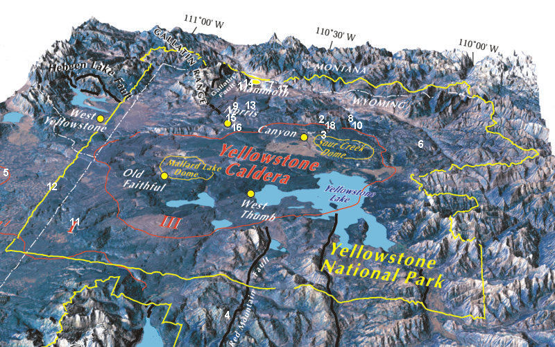
The Yellowstone caldera already erupted three times in the recent past: at 2.1, 1.3, and 0.64 million years ago [1]. Each eruption created large rhyolite lava flows and pyroclastic clouds of ash that solidified into tuff. These extra-large eruptions rapidly emptied the magma chamber causing the roof to collapse and form a caldera. Three calderas are still preserved from these eruptions, and most of the roads and hotels of Yellowstone National Park are located within the caldera [1].
***See 5.8 for Text and Media Attributions
an area on the Earth's surface where lava, ash, and/or volatile gases erupt and eventually solidify into rock.
molten rock that can be found beneath the Earth's surface.
originating from a feldspar and silica-rich magma/lava composition.
Originating from an iron and magnesium-rich magma/lava composition.
The solidification of loose sediment materials as solid sedimentary rock through compacting pressures and cementation.
Gases dissolved within magma or lava.
molten rock that has erupted at the Earth's surface due to volcanic processes.
ejected rock and particle fragments from volcanic eruptions.
As previously discussed in section 3.9, a rock is a collection of consolidated minerals. Rocks are grouped into three main categories based on how they form:
- Igneous: formed from the cooling and crystallization of molten rock.
- Sedimentary: formed when weathered fragments of other rocks are buried, compressed, and cemented together, or when minerals precipitate directly from solution
- Metamorphic: formed by alteration (due to heat, pressure, and/or chemical action) of a pre-existing igneous or sedimentary rock
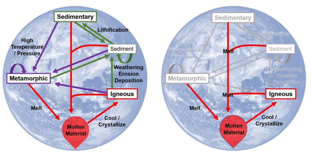
The focus of this chapter is on Igneous rocks, though it is important to remember this is just a piece of the rock cycle.
Learning Objectives
After carefully reading this chapter, completing the exercises within it, and answering the questions at the end, you should be able to:
- Describe the rock cycle and the types of processes that lead to the formation of igneous, sedimentary, and metamorphic rocks, and explain why there is an active rock cycle on Earth.
- Explain the concept of partial melting and describe the geological processes that lead to melting.
- Describe, in general terms, the range of chemical compositions of magmas.
- Discuss the processes that take place during the cooling and crystallization of magma, and the typical order of crystallization according to the Bowen reaction series.
- Explain how magma composition can be changed by fractional crystallization and partial melting of the surrounding rocks.
- Apply the criteria for igneous rock classification based on mineral proportions.
- Describe the origins of phaneritic, porphyritic, and pegmatitic rock textures.
- Identify plutons on the basis of their morphology and their relationships to the surrounding rocks.
- Explain the origin of a chilled margin.
Fine-grained, or microcrystalline, igneous rock texture.
Mechanisms
Sea-level change has been a feature on Earth for billions of years, and it has important implications for coastal processes and both erosional and depositional features. There are three primary mechanisms of sea-level change, as described below.

Eustatic
Eustatic sea-level changes are global sea-level changes related to changes in the volume of glacial ice on land or changes in the shape of the seafloor caused by plate tectonic processes. For example, changes in the rate of mid-ocean spreading will change the seafloor's shape near the ridges, which affects sea level. Over the past 20,000 years, there have been approximately 125 meters (410 feet) of eustatic sea-level rise due to glacial melting. Most of that took place between 15,000 and 7,500 years ago during the significant melting phase of the North American and Eurasian Ice Sheets. At around 7,500 years ago, the rate of glacial melting and sea-level rise decreased dramatically, and since that time, the average rate has been in the order of 0.7 mm/year. Anthropogenic climate change led to an accelerating sea-level rise starting around 1870. Since that time, the average rate has been 1.1 mm/year, but it has been gradually increasing. Since 1992, the average rate has been 3.2 mm/year. (4)
Isostatic
Isostatic sea-level changes are local changes caused by subsidence or uplift of the crust related either to changes in the amount of ice on the land or to growth or erosion of mountains. Almost all of Canada and parts of the northern United States were covered in thick ice sheets at the peak of the last glaciation. Following the melting of this ice, there has been an isostatic rebound of continental crust in many areas. This ranges from several hundred meters of rebound in the central part of the Laurentide Ice Sheet (around Hudson Bay) to 100 m to 200 m in the peripheral parts of the Laurentide and Cordilleran Ice Sheets - in places such as Vancouver Island and the mainland coast of BC. Although the global sea level was about 130 m lower during the last glaciation, the glaciated regions were depressed at least that much in most places, and more than that in places where the ice was thickest. (7)
Tectonic
Tectonic sea-level changes are local changes caused by tectonic processes. The subduction of the Juan de Fuca Plate beneath British Columbia creates tectonic uplift (about 1 mm/year) along the western edge of Vancouver Island, although much of this uplift is likely to be reversed when the next sizeable subduction-zone earthquake strikes. (4)
Emergent and Submergent Coasts
Coastlines that have a relative fall in sea level, either caused by tectonics or sea-level change, are called emergent. Where the shoreline is rocky, with a sea cliff, waves refracting around headlands attack the rocks behind the point of the headland.
They may cut out the rock at the base forming a sea arch that may collapse to isolate the point as a stack. Rocks behind the stack may be eroded, and sand eroded from the point collects behind it, forming a tombolo, a sand strip that connects the stack to the shoreline. Where sand supply is low, wave energy may erode a wave-cut platform across the surf zone, exposed as bare rock with tidal pools at low tide. Sea cliffs tend to be persistent features as the waves cut away at their base, and higher rocks calve off by mass wasting. If the coast is emergent, these erosional features may be elevated compared to the wave zone. Wave-cut platforms become marine terraces, with remnant sea cliffs inland from them. (4)
Tectonic subsidence or sea-level rise produces a submergent coast. Features associated with submergence coasts include estuaries, bays, and river mouths flooded by the higher water. Fjords are ancient glacial valleys now flooded by post-Ice Age sea level rise. Barrier islands form parallel to the shoreline from the old beach sands, often isolated from the mainland by lagoons behind them. Some scientists hypothesize that barrier islands formed by rising sea levels as the ice sheets melted after the last ice age. Accumulation of spits and far offshore bar formations are also mentioned as formation hypotheses for barrier islands.
Estuaries and fiords commonly characterize coastlines in areas where there has been a net sea-level rise in the geologically recent past. This valley was filled with ice during the last glaciation, and there has been a net rise in sea level here since that time. Uplifted wave-cut platforms or stream valleys characterize coastlines in areas where there has been a net sea-level drop in the geologically recent past. Uplifted beach lines are another product of relative sea-level drop, although these are difficult to recognize in areas with vigorous vegetation.
Backyard Geology: Sea-level changes recorded in rocks
While it seems fairly obvious that there are no real coastlines in Arizona currently, their existence is preserved in rocks throughout the state. These ancient deposits imply that they were formed in a similar environment as the rocks of present day, so there must have been oceans and shorelines throughout Arizona in the past.
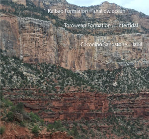
Figure 8.5.2 shows the three uppermost layers of the Grand Canyon. Though these layers were deposited millions of years ago, they preserve the environments that were present at their time of deposition. The Kaibab Formation, the youngest set of rocks found in the Grand Canyon, are a 270 million-year-old limestone that was deposited in a shallow marine (ocean) environment. The Toroweap Formation was formed in an intertidal zone, as sea-level changed several times. The older Coconino Sandstone is a 275 million-year-old wind-blown sand which forms a dramatic cliff in the present day. Together, these rock show that sea-level changed dramatically in just 5 million years, and much of Arizona was entirely under water!
As previously discussed in section 3.9, a rock is a collection of consolidated minerals. Rocks are grouped into three main categories based on how they form:
- Igneous: formed from the cooling and crystallization of molten rock.
- Sedimentary: formed when weathered fragments of other rocks are buried, compressed, and cemented together, or when minerals precipitate directly from solution
- Metamorphic: formed by alteration (due to heat, pressure, and/or chemical action) of a pre-existing igneous or sedimentary rock
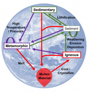

The focus of this chapter is on Igneous rocks, though it is important to remember this is just a piece of the rock cycle.
Learning Objectives
After carefully reading this chapter, completing the exercises within it, and answering the questions at the end, you should be able to:
- Describe the rock cycle and the types of processes that lead to the formation of igneous, sedimentary, and metamorphic rocks, and explain why there is an active rock cycle on Earth.
- Explain the concept of partial melting and describe the geological processes that lead to melting.
- Describe, in general terms, the range of chemical compositions of magmas.
- Discuss the processes that take place during the cooling and crystallization of magma, and the typical order of crystallization according to the Bowen reaction series.
- Explain how magma composition can be changed by fractional crystallization and partial melting of the surrounding rocks.
- Apply the criteria for igneous rock classification based on mineral proportions.
- Describe the origins of phaneritic, porphyritic, and pegmatitic rock textures.
- Identify plutons on the basis of their morphology and their relationships to the surrounding rocks.
- Explain the origin of a chilled margin.
Topography of the Sea Floor
Oceans cover 71% of Earth’s surface and hold 97% of Earth’s water. The water the oceans hold is critical to plate tectonics, volcanism, and, of course, life on Earth. We know more about the surface of the Moon than the floor of the oceans. Whether this is true or not, the critical point is that the ocean floor is covered with an average of nearly 4,000 m of water, and it is pitch black below a few hundred meters, so it is not easy to discover what is down there. We know a lot more about the oceans than we used to, but there is still a great deal more to discover. (4)
Earth has had oceans for a very long time, dating back to the point where the surface had cooled enough to allow liquid water, only a few hundred million years after Earth's formation. At that time, there were no continental rocks, so the water that was here was likely spread out over the surface in one giant (but relatively shallow) ocean. (4)
We examined the seafloor's topography from the perspective of plate tectonics, but here we are going to take another look at the essential features from an oceanographic perspective. The essential features are the extensive continental shelves less than 250 m deep (pink); the vast deep abyssal plains between 3,000 and 6,000 m deep (light and dark blue); the mid-Atlantic ridge, in many areas shallower than 3,000 m; and the deep ocean trench north of Puerto Rico. (4) These features are connected by continental slopes, which is the transition area between continental shelves and abyssal planes.

Of course, it is more complicated than this, even in this simplified form. Figure 8.4.2 shows a generalized cross-section of the Pacific Ocean which has short continental shelves that quickly turn to continental slopes, dropping from about 200 m to several thousand meters over a distance of a few hundred kilometers. The continental slopes connect to abyssal plains – exceedingly flat and from 4,000 m to 6,000 m deep; volcanic seamounts and islands; and trenches at subduction zones that are up to 11,000 m deep.
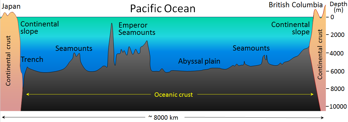
The ocean floor is entirely underlain by mafic oceanic crust, while the continental slopes are underlain by felsic continental crust (mostly granitic and sedimentary rocks). Moreover, the denser oceanic crust floats lower on the mantle than continental crust does, and that is why oceans are oceans. Although the temperature of the ocean surface varies widely, from a few degrees either side of freezing in polar regions to over 25°C in the tropics, in most parts of the ocean, the water temperature is around 10°C at 1,000 m depth and about 4°C from 2,000 m depth to the bottom. (4)
The deepest parts of the ocean are within the subduction trenches, and the deepest of these is the Marianas Trench in the southwestern Pacific (near Guam) at 11,000 m. Other trenches in the southwestern Pacific are over 10,000 m deep; the Japan Trench is over 9,000 m deep, and the Puerto Rico and Chile-Peru Trenches are over 8,000 m deep. Shallow trenches tend to be that way because they have significant sediment infill. There is no recognizable trench along the subduction zone of the Juan de Fuca Plate because it has been filled with sediments from the Fraser and Columbia Rivers. (4)
Landforms of Coastal Erosion
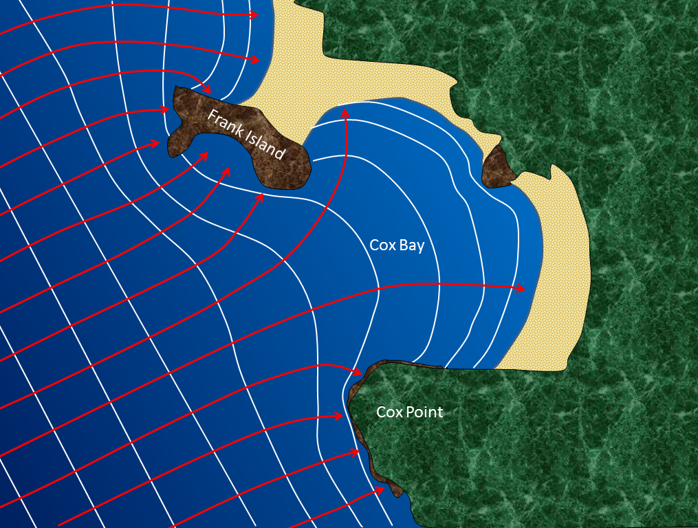
Large waves crashing onto a shore bring a tremendous amount of energy that has a significant eroding effect, and several unique erosion features commonly form on rocky shores with strong waves. When waves approach an irregular shore, they are slowed down to varying degrees, depending on differences in the water depth, and as they slow, they are bent or refracted. That energy is evenly spaced out in the deep water, but because of refraction, the waves' energy, which moves perpendicular to the wave crests, is being focused on the headlands. On irregular coasts, the headlands receive much more wave energy than the intervening bays, and thus they are more strongly eroded. The result of this is coastal straightening. An irregular coast, like the west coast of Vancouver Island, will eventually become straightened, although that process will take millions of years. (4)
Wave erosion is highest in the surf zone, where the wave base is impinging strongly on the seafloor and where the waves are breaking. The result is that the substrate in the surf zone is typically eroded to a flat surface known as a wave-cut platform. A wave-cut platform extends across the intertidal zone. (4)
Resistant rock that does not get eroded entirely during the formation of a wave-cut platform will remain behind to form a stack. Here the different layers of the sedimentary rock have different resistance to erosion. The upper part of this stack is made up of rock that resisted erosion, and that rock has protected a small pedestal of underlying softer rock. The softer rock will eventually be eroded, and the big rock will become just another boulder on the beach.
Arches and sea caves are related to stacks because they all form because of the erosion of non-resistant rock. (4)

Submarine Canyons
Submarine canyons are narrow and deep canyons located in the marine environment on continental shelves. They typically form at the mouths of sizeable landward river systems, both by cutting down into the continental shelf during low sea levels and by continual material slumping or flowing down from the mouth of the river or a delta. Underwater currents rich in sediment pass through the canyons, erode them and drain onto the ocean floor. Steep delta faces and underwater flows of sediments are released down the continental slope as underwater landslides, called turbidity flows. The erosive action of this type of flow continues to cut the canyon, and eventually, fan-shaped deposits develop on the ocean floor beyond the continental slope. (4)
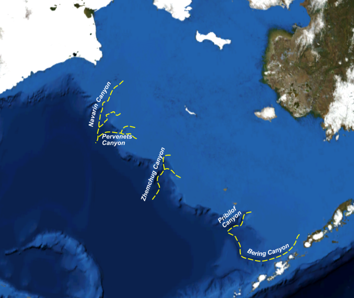
Landforms of Coastal Deposition
Some coastal areas are dominated by erosion, an example being the Pacific coast of Canada and the United States, while others are dominated by deposition, examples being the Atlantic and Caribbean coasts of the United States. However, on almost all coasts, deposition and erosion are happening to vary degrees most of the time, although in various places. On deposition-dominant coasts, the coastal sediments are still being eroded from some areas and deposited in others.
The main factor in determining if the coast is dominated by erosion or deposition is its history of tectonic activity. A coast like that of British Columbia is tectonically active, and compression and uplift have been going on for tens of millions of years. This coast has also been uplifted during the past 15,000 years by isostatic rebound due to deglaciation. The coasts of the United States along the Atlantic and the Gulf of Mexico have not seen significant tectonic activity in a few hundred million years, and except in the northeast, have not experienced post-glacial uplift. These areas have relatively little topographic relief, and there is now minimal erosion of coastal bedrock. (4)
On coasts dominated by depositional processes, most of the sediment being deposited typically comes from large rivers. An obvious example is where the Mississippi River flows into the Gulf of Mexico at New Orleans; another is the Fraser River in Vancouver. No large rivers bring sandy sediments to the west coast of Vancouver Island, but there are still long and wide sandy beaches there. In this area, most of the sand comes from glaciofluvial sand deposits situated along the shore behind the beach, and some come from the erosion of the rocks on the headlands. (4)
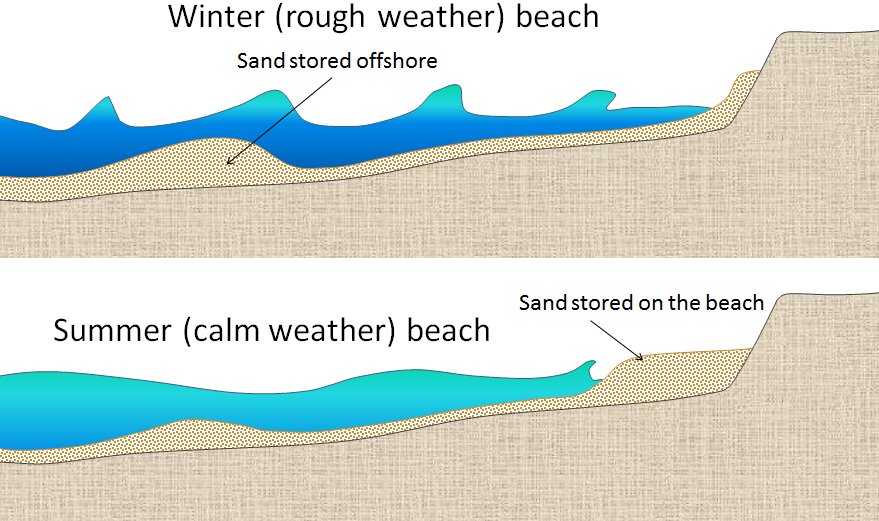
Most beaches go through a seasonal cycle because conditions change from summer to winter. In summer, sea conditions are calm with long-wavelength, low-amplitude waves generated by distant winds. Winter conditions are rougher, with shorter-wavelength, higher-amplitude waves caused by strong local winds. As seen in Figure 14.4.7, the heavy seas of winter gradually erode sand from beaches, moving it to an underwater sandbar offshore. The gentler waves of summer gradually push this sand back toward the shore, creating a broader and flatter beach. (4)

The evolution of sandy depositional features on seacoasts is primarily influenced by waves and currents, especially longshore currents. As sediment is transported along a shore, either it is deposited on beaches, or it creates other depositional features. For example, a spit is an elongated sandy deposit that extends out into open water in the direction of a longshore current. (4)
A spit that extends across a bay to the extent of closing, or almost closing it off, is known as a baymouth bar. Most bays have streams flowing into them, and since this water must get out, rarely, a baymouth bar will completely close the entrance to a bay. In areas where there is sufficient sediment being transported, and there are nearshore islands, a tombolo may form.
Tombolos are common where islands are abundant, and they typically form where there is a wave shadow behind a nearshore island. This becomes an area with reduced energy, and so the longshore current slows, and sediments accumulate. Eventually, enough sediments accumulate to connect the island to the mainland with a tombolo. (4)

In areas where coastal sediments are abundant and coastal relief is low (because there has been little or no recent coastal uplift), it is common for barrier islands to form. Barrier islands are elongated islands composed of sand that form a few kilometers away from the mainland. They are common along the US Gulf Coast from Texas to Florida, and along the US Atlantic Coast from Florida to Massachusetts. North of Boston, the coast becomes rocky, partly because that area has been affected by a post-glacial crustal rebound. (4) Barrier islands do an excellent job of blocking incoming storm surges from hurricanes, but since they are made almost entirely of sand they shift and move with every storm event. Though they are largely unstable for building and infrastructure, many people live on barrier islands and have to regularly face coastal hazards. The 2000 U.S. Census estimates that there are 1.4 million people living on barrier islands, with a population density of three times that of the coast.
So, you want to learn about rocks? First you need to understand minerals, since they are the components of all the rocks on Earth. Much like ingredients while cooking, minerals are the tomatoes, onions, and noodles of our geologic lasagna. Minerals are all around us: the graphite in your pencil, the salt on your table, the plaster on your walls, and the trace amounts of gold in your computer. Minerals can be found in a wide variety of consumer products including paper, medicine, processed foods, cosmetics, electronic devices, and many more. And of course, everything made of metal is also derived from minerals. A mineral is a naturally occurring combination of specific elements arranged in a particular repeating three-dimensional structure. The combination of specific minerals will make up different rock types.
Learning Objectives
After reading this chapter, completing the exercises within it, and answering the questions at the end, you should be able to:
- Describe the nature of atoms and their constituents, particularly the behavior of electrons and the formation of ions.
- Apply your understanding of atoms to explain bonding within minerals.
- Describe mineral lattices and explain how they influence mineral properties.
- Categorize minerals into groups based on their compositions.
- Describe a silica tetrahedron and the ways in which tetrahedra combine to make silicate minerals.
- Differentiate between ferromagnesian and other silicate minerals.
- Explain some of the mechanisms of mineral formation.
- Describe some of the important techniques for identifying minerals.
a liquid's resistance to flow or movement
Scientific Method in Geosciences: Multiple hypotheses, Multiple modes of Inquiry
How is science made in Earth Sciences? Why should you care? Even if you are not interested in becoming an Earth scientist, or any kind of scientist, understanding how science works is a source of empowerment. This is because science and scientific thinking are at the heart of our modern way of life and they influence every aspect of our lives. Understanding how science works can help you discern fact from fiction and inform your life choices and political decisions.
Modern science is based on the scientific method, the idea in science that phenomena and ideas need to be scrutinized using hypothesizing, experimentation, and analysis. This can eventually result in a consensus or scientific theory.
The scientific method, is a procedure that follows these steps:
- Formulate a question or observe a problem
- Apply objective experimentation and observation
- Analyze collected data and Interpret results.
- Devise an evidence-based theory.
- Submit findings to peer review.
Let's see how scientific inquiry works in Earth science.
1. Observation, problem, or research question
The procedure begins when scientists identify a problem or research question, such as a geological phenomenon that is not well explained in the scientific community’s collective knowledge. This step usually involves reviewing the scientific literature to establish what is known and to consult previous studies related to the question.
Earth scientists can study processes they cannot observe directly, because they happen over long periods of time, or happened long ago, or happen in a remote location. An example of the last one would be the Earth's core. To circumvent these challenges, Earth scientists have developed strategies to test their hypothesis, these strategies make up the scientific method of geosciences.
2. Hypothesis
Once the scientists define the problem or question, they propose a possible answer, a hypothesis
hypotheses to gather data from multiple lines. To test hypotheses, scientists use methods drawn from other sciences such as chemistry, physics, biology, or even engineering.
3. Testing Hypotheses: Experiments and Revisions

The next step is developing an <span aria-describedby="tt" data-cmtooltip="
Earth scientists conduct classic experiments in the lab, however, an
An experiment can take other forms such as:
- Observing natural processes and their products in the field and comparing them to those found in the rock record. E.g., A sedimentologist studies how wind moves and forms dunes and different ripples in a desert. This knowledge helps her to interpret ripple structures found in rocks, and even to interpret dunes and aeolian processes from images collected on Mars!
- Studying changes across time or space. E.g., an atmospheric scientist analyzes how the composition of the atmosphere has changed since we started measuring it.
- Using physical models. This is more akin to the "classic experiment". E.g., a team of scientists build a model for landslides using a long and steep ramp and flushing down different materials, and changing the ramp angle.
- Using computer models. E.g., climatologists develop computational models to study the climate system and make predictions. These scientific models undergo rigorous scrutiny and testing by collaborating and competing groups of scientists around the world.
- Considering multiple lines of evidence. To establish a scientific finding, all lines of evidence must converge, that means that all the results you collect using different methods must agree with the finding, the math must be sound, and the methods must be thoroughly described.
Regardless of what form an <span aria-describedby="tt" data-cmtooltip="
">experiment takes, it always includes the systematic gathering of <span aria-describedby="tt" data-cmtooltip="
">objective data. The scientists interpret this data to determine whether it contradicts or supports the <span aria-describedby="tt" data-cmtooltip="
">hypothesis (step 2). If the results contradict the hypothesis, then scientists can revise it and test it again. When a <span aria-describedby="tt" data-cmtooltip="
">hypothesis holds up under experimentation, it is ready to be shared with other experts in the field. The findings are scrutinized by the scientific community through the process of peer review.
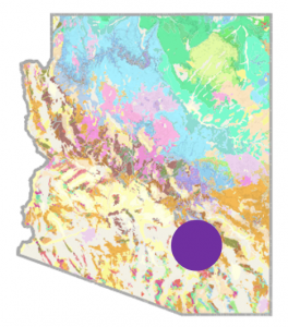 Backyard Geology: Arizona Wildfire Study in Saguaro National Park
Arizona ranks high in the number of individual fires, as well as acres burned, every year. Below are the top 10 states for wildfires:
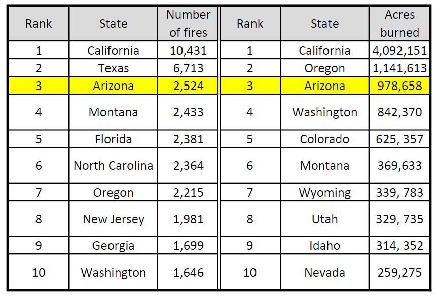
In 2020, Arizona ranked 3rd out of all states in both categories, with 2,524 individual fires and 978,568 acres burned. Why does Arizona have so many fires? Wildfire risk depends on many factors, including temperature, soil moisture, and the presence of vegetation (fuel) to burn. Certainly the dry, hot climate plays a role, and climate change intensifies drought conditions, but what contributes to the fuel available to burn?
It was determined in a previous study that invasive buffelgrass is fire-adapted, meaning it establishes, persists, and spreads following fire. It also outcompetes native vegetation for resources, supplies material that can be readily burned, and connects areas subjected to wildfires. Therefore, can we control or remove buffelgrass in the Arizona wilderness?
- Research Question: Invasive buffelgrass contributes to wildfires, can it be controlled or removed in wilderness areas?
- Hypothesis: If buffelgrass can be controlled, the intensity and interconnectedness of wildfires will lessen and cause less devastation.
- Experiment: Herbicides were used to control dense patches of buffelgrass in remote areas. The herbicide was applied with the use of helicopters.
- Results:
4. Peer review, publication, and replication
Science is a social process. Scientists share the results of their research in conferences and by publishing articles in scientific journals, such as Science and Nature. Reputable journals and academic outlets will not publish an experimental study until they have determined its methods are scientifically rigorous and the evidence supports the conclusions. Before they publish the article, scientific experts in the field scrutinize the methods, results, and discussion; the peer review process. Once an article is published, other scientists may attempt to replicate the results. This replication is necessary to confirm the reliability of the study’s reported results. A <span aria-describedby="tt" data-cmtooltip="
">hypothesis that seemed compelling in one study might be proven false in studies conducted by other scientists. New technology can be applied to published studies, which can aid in confirming or rejecting once-accepted ideas and/or <span aria-describedby="tt" data-cmtooltip="
">hypotheses.
5. Theory development

In casual conversation, the word <span aria-describedby="tt" data-cmtooltip="
">theory implies guesswork or speculation. In the language of science, an explanation or conclusion made into a <span aria-describedby="tt" data-cmtooltip="
">theory carries much more weight because experiments support it and the scientific community widely accepts it. A <span aria-describedby="tt" data-cmtooltip="
">hypothesis that has been repeatedly confirmed through documented and independent studies eventually becomes accepted as a scientific <span aria-describedby="tt" data-cmtooltip="
">theory.
While a <span aria-describedby="tt" data-cmtooltip="
">hypothesis provides a tentative explanation before an <span aria-describedby="tt" data-cmtooltip="
">experiment, a <span aria-describedby="tt" data-cmtooltip="
">theory is the best explanation after being confirmed by multiple independent experiments. Confirmation of a <span aria-describedby="tt" data-cmtooltip="
">theory may take years, or even longer. For example, the scientific community initially dismissed the <span aria-describedby="tt" data-cmtooltip="
">continental drift <span aria-describedby="tt" data-cmtooltip="
">hypothesis first proposed by Alfred Wegener in 1912 (see Chapter 2). After decades of additional evidence collection by other scientists using more advanced technology, Wegener’s <span aria-describedby="tt" data-cmtooltip="
">hypothesis was accepted and revised as the <span aria-describedby="tt" data-cmtooltip="
">theory of <span aria-describedby="tt" data-cmtooltip="
The <span aria-describedby="tt" data-cmtooltip="
">theory of evolution by natural selection is another example. Originating from the work of Charles Darwin in the mid-19th century, the <span aria-describedby="tt" data-cmtooltip="
">theory of evolution has withstood generations of scientific testing for falsifiability. It has been updated and revised to accommodate knowledge gained by using modern technologies, but the latest evidence continues to support the <span aria-describedby="tt" data-cmtooltip="
">theory of evolution.
Science
We have covered the scientific method of the geosciences. However, science is a human endeavor. For generations, Indigenous peoples have accrued empirical knowledge of the natural world, including the lithosphere. Greg Cajete uses the name Native Science to refer to "the collective heritage of human experience with the natural world" (Cajete, 2000). Geologic expertise served tribal peoples in many of the same ways that Western geology serves modern civilizations. For example, Native Americans in Cascadia record volcanic events in stories, this transmits cross-generational awareness of volcanic hazards; the Muiscas in Colombia knew how to find, mine and process the gold to make beautiful art pieces; and the Puebloans of the North American Southwest managing limited water resources using an impressive net of canals that we still use for our benefit. Western and Native scientists can collaborate to further our understanding of the Earth systems and to remember how to live well on our planet.
Science is a dynamic process. Technological advances, breakthroughs in interpretation, and new observations continuously refine our understanding of Earth. We will never stop learning about our Earth. As new findings are published, we must revise and update our scientific knowledge and discard ideas that are proven false by new observations. Science is a living entity.
In conclusion, Earth scientists do not use a single, all-encompassing "scientific method". Instead, multiple modes of inquiry respond to the complexity and spatial and temporal scales of Earth systems.
"The unique thing about the geosciences is that the knowledge, skills, and methods are brought together, refined, and evolved over time to make them most suitable for understanding the complex processes of Earth, its working in the past and the present, and its likely behavior in the future." (Manduca and Kastens, 2012).
Key Takeaways
- Earth scientists work on challenging problems that face humanity on topics such as climate change, human impacts on Earth, and hazards to humans.
- Besides the classical laboratory experiment, Earth scientists construct models or use indirect methods to study the Earth.
- Scientific results are not valid or useful unless other scientists can reproduce them. Research results undergo scrutiny by the community before and after being published.
- The study of geological and environmental issues requires multiple disciplines and the interplay of multiple methods.
- Scientific thinking advances through collaboration and community.
GeoEthics
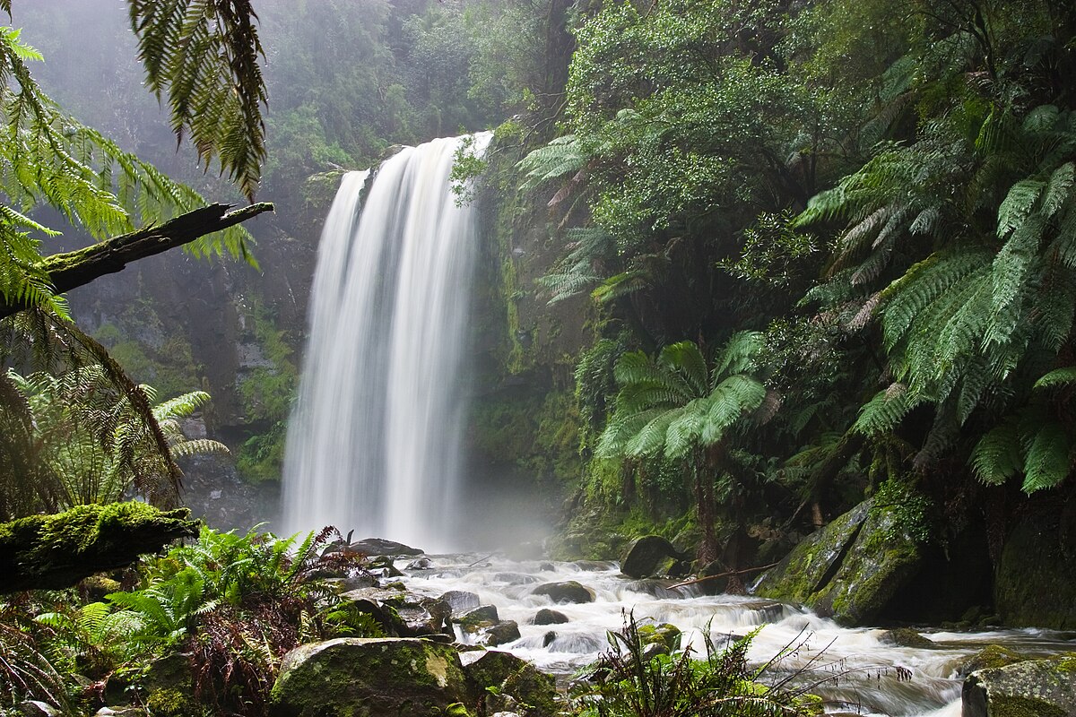
Geoscientists must act in ethical ways to contribute to the welfare of human beings. The saying "with great knowledge comes great responsibility" holds true for Earth and environmental scientists. Earth scientist must uphold high standards in research and conduct. The research and reflection upon the values which underpin behaviors and practices between humans and Earth systems is the arena of the "Geoethics" (Di Capua and Peppoloni, 2019). The International Association for Promoting Geoethics (IAPG) provide tools to "understand the complex relationship between human action on ecosystems and the decisions geoscientists make in the discipline that impact society, including improving the awareness of professionals, students, decision-makers, media operators, and the public on an accountable and ecologically sustainable development." Source: https://www.geoethics.org/geoethics-school
All of us, human beings, have responsibilities to Earth. We do not exist apart from this planet and our behaviors impact other people, other species, the larger biosphere, hydrosphere, atmosphere, and lithosphere. Our actions impact the Earth system. As you progress in your learning, strive to think critically and to identify ethical issues. Do not be afraid to question and discuss your observations with your instructor and with peers. Just remember to do so respectfully, considering other points of view and practicing active listening.
A region along Earth's lithosphere where at least two tectonic plates move apart from one another.
The world's greatest Mass Extinction event that occurred around 252 million years ago and resulted in the loss of 95% of ocean life and 70% of life on land.
Image by James St. John (Flickr), CC BY 2.0
As previously discussed in section 3.9, a rock is a collection of consolidated minerals. Rocks are grouped into three main categories based on how they form:
- Igneous: formed from the cooling and crystallization of molten rock.
- Sedimentary: formed when weathered fragments of other rocks are buried, compressed, and cemented together, or when minerals precipitate directly from solution
- Metamorphic: formed by alteration (due to heat, pressure, and/or chemical action) of a pre-existing igneous or sedimentary rock

The focus of this chapter is on Igneous rocks, though it is important to remember this is just a piece of the rock cycle.
Learning Objectives
After carefully reading this chapter, completing the exercises within it, and answering the questions at the end, you should be able to:
- Describe the rock cycle and the types of processes that lead to the formation of igneous, sedimentary, and metamorphic rocks, and explain why there is an active rock cycle on Earth.
- Explain the concept of partial melting and describe the geological processes that lead to melting.
- Describe, in general terms, the range of chemical compositions of magmas.
- Discuss the processes that take place during the cooling and crystallization of magma, and the typical order of crystallization according to the Bowen reaction series.
- Explain how magma composition can be changed by fractional crystallization and partial melting of the surrounding rocks.
- Apply the criteria for igneous rock classification based on mineral proportions.
- Describe the origins of phaneritic, porphyritic, and pegmatitic rock textures.
- Identify plutons on the basis of their morphology and their relationships to the surrounding rocks.
- Explain the origin of a chilled margin.
Scientific Method in Geosciences: Multiple hypotheses, Multiple modes of Inquiry
How is science made in Earth Sciences? Why should you care? Even if you are not interested in becoming an Earth scientist, or any kind of scientist, understanding how science works is a source of empowerment. This is because science and scientific thinking are at the heart of our modern way of life and they influence every aspect of our lives. Understanding how science works can help you discern fact from fiction and inform your life choices and political decisions.
Modern science is based on the scientific method, the idea in science that phenomena and ideas need to be scrutinized using hypothesizing, experimentation, and analysis. This can eventually result in a consensus or scientific theory.
The scientific method, is a procedure that follows these steps:
- Formulate a question or observe a problem
- Apply objective experimentation and observation
- Analyze collected data and Interpret results.
- Devise an evidence-based theory.
- Submit findings to peer review.
Let's see how scientific inquiry works in Earth science.
1. Observation, problem, or research question
The procedure begins when scientists identify a problem or research question, such as a geological phenomenon that is not well explained in the scientific community’s collective knowledge. This step usually involves reviewing the scientific literature to establish what is known and to consult previous studies related to the question.
Earth scientists can study processes they cannot observe directly, because they happen over long periods of time, or happened long ago, or happen in a remote location. An example of the last one would be the Earth's core. To circumvent these challenges, Earth scientists have developed strategies to test their hypothesis, these strategies make up the scientific method of geosciences.
2. Hypothesis
Once the scientists define the problem or question, they propose a possible answer, a hypothesis: A proposed explanation for an observation that can be tested. Hypotheses must be testable and falsifiable.
To test hypotheses, scientists use methods drawn from other sciences such as chemistry, physics, biology, or even engineering.
3. Testing Hypotheses: Experiments and Revisions

The next step is developing an experiment: A test of an idea in which new information can be gathered to either accept or reject a hypothesis.
Earth scientists conduct classic experiments in the lab, however, an experiment can take other forms such as:
- Observing natural processes and their products in the field and comparing them to those found in the rock record. E.g., A sedimentologist studies how wind moves and forms dunes and different ripples in a desert. This knowledge helps her to interpret ripple structures found in rocks, and even to interpret dunes and aeolian processes from images collected on Mars!
- Studying changes across time or space. E.g., an atmospheric scientist analyzes how the composition of the atmosphere has changed since we started measuring it.
- Using physical models. This is more akin to the "classic experiment". E.g., a team of scientists build a model for landslides using a long and steep ramp and flushing down different materials, and changing the ramp angle.
- Using computer models. E.g., climatologists develop computational models to study the climate system and make predictions. These scientific models undergo rigorous scrutiny and testing by collaborating and competing groups of scientists around the world.
- Considering multiple lines of evidence. To establish a scientific finding, all lines of evidence must converge, that means that all the results you collect using different methods must agree with the finding, the math must be sound, and the methods must be thoroughly described.
Regardless of what form an experiment takes, it always includes the systematic gathering of objective data. The scientists interpret this data to determine whether it contradicts or supports the hypothesis. If the results contradict the hypothesis, then scientists can revise it and test it again. When a hypothesis holds up under experimentation, it is ready to be shared with other experts in the field. The findings are scrutinized by the scientific community through the process of peer review.
4. Peer review, publication, and replication
Science is a social process. Scientists share the results of their research in conferences and by publishing articles in scientific journals, such as Science and Nature. Reputable journals and academic outlets will not publish an experimental study until they have determined its methods are scientifically rigorous and the evidence supports the conclusions. Before they publish the article, scientific experts in the field scrutinize the methods, results, and discussion; the peer review process. Once an article is published, other scientists may attempt to replicate the results. This replication is necessary to confirm the reliability of the study’s reported results. A hypothesis that seemed compelling in one study might be proven false in studies conducted by other scientists. New technology can be applied to published studies, which can aid in confirming or rejecting once-accepted ideas and/or hypotheses.
 Backyard Geology: Wildfire in Saguaro National Park
Arizona ranks high in the number of individual fires, as well as acres burned, every year. In 2020, Arizona ranked 3rd out of all states in both categories, with 2,524 individual fires and 978,568 acres burned. Below are the top 10 states for wildfires:

Why does Arizona have so many fires? Wildfire risk depends on many factors, including temperature, soil moisture, and the presence of vegetation (fuel) to burn. Certainly the dry, hot climate plays a role, and climate change intensifies drought conditions, but what contributes to the fuel available to burn?
In Saguaro National Park, an invasive noxious weed, called buffelgrass is changing the natural ecosystem and increasing the park's susceptibility to wildfire. Buffelgrass, unlike native vegetation, evolved with fire and thrives under repeated burning. It outcompetes native vegetation for resources, supplies material that can be readily burned, and connects areas subjected to wildfires. Steps have been taken to remove buffelgrass, including physical weeding and also using herbicides. Some areas are remote, and herbicides are applied by helicopter. What effect does this application have?
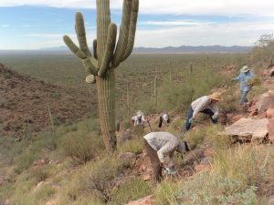
What geologists do? The United States Geological Survey (USGS) conducted a study to determine the effects of aerial dispersal of herbicide for buffelgrass control.
- Research Question: What are the potential transport and effects to aquatic ecosystems of the herbicides used for buffelgrass removal?
- Hypothesis: Herbicides will move into water environments and potentially be harmful to ecosystems and humans.
- Experiment: Three watersheds, treated with different amounts of herbicide, were regularly sampled to determine residual amounts of herbicides present in soil and water.
- Publication of results: While no water concentrations exceeded published criteria for human health or aquatic life, the authors acknowledge that it is a complex system that necessitates future study.
5. Theory development

In casual conversation, the word theory implies guesswork or speculation. In the language of science, an explanation or conclusion made into a carries much more weight because experiments support it and the scientific community widely accepts it. A hypothesis that has been repeatedly confirmed through documented and independent studies eventually becomes accepted as a scientific theory.
While a hypothesis provides a tentative explanation before an experiment, a theory is the best explanation after being confirmed by multiple independent experiments. Confirmation of a theory may take years, or even longer. For example, the scientific community initially dismissed the Continental Drift hypothesis first proposed by Alfred Wegener in 1912 (see Chapter 2). After decades of additional evidence collection by other scientists using more advanced technology, Wegener’s hypothesis was used as the framework and revised as the theory of Plate Tectonics.
In biology, theory of evolution by natural selection is another example. Originating from the work of Charles Darwin in the mid-19th century, the theory of evolution has withstood generations of scientific testing for falsifiability. It has been updated and revised to accommodate knowledge gained by using modern technologies, but the latest evidence continues to support the theory of evolution.
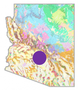 Science in Many Cultures
We have covered the scientific method of the geosciences. However, science is a human endeavor. For generations, Indigenous peoples have accrued empirical knowledge of the natural world, including the lithosphere. Greg Cajete uses the name Native Science to refer to "the collective heritage of human experience with the natural world" (Cajete, 2000). Geologic expertise served tribal peoples in many of the same ways that Western geology serves modern civilizations.
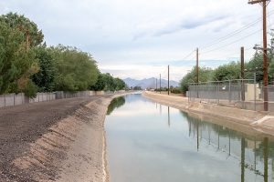
For example, Native Americans in Cascadia record volcanic events in stories, this transmits cross-generational awareness of volcanic hazards; the Muiscas in Colombia knew how to find, mine and process the gold to make beautiful art pieces; and the Puebloans of the North American Southwest managing limited water resources using an impressive net of canals that we still use for our benefit. Western and Native scientists can collaborate to further our understanding of the Earth systems and to remember how to live well on our planet.
Science is a dynamic process. Technological advances, breakthroughs in interpretation, and new observations continuously refine our understanding of Earth. We will never stop learning about our Earth. As new findings are published, we must revise and update our scientific knowledge and discard ideas that are proven false by new observations. Science is a living entity.
In conclusion, Earth scientists do not use a single, all-encompassing "scientific method". Instead, multiple modes of inquiry respond to the complexity and spatial and temporal scales of Earth systems.
"The unique thing about the geosciences is that the knowledge, skills, and methods are brought together, refined, and evolved over time to make them most suitable for understanding the complex processes of Earth, its working in the past and the present, and its likely behavior in the future." (Manduca and Kastens, 2012).
Key Takeaways
- Earth scientists work on challenging problems that face humanity on topics such as climate change, human impacts on Earth, and hazards to humans.
- Besides the classical laboratory experiment, Earth scientists construct models or use indirect methods to study the Earth.
- Scientific results are not valid or useful unless other scientists can reproduce them. Research results undergo scrutiny by the community before and after being published.
- The study of geological and environmental issues requires multiple disciplines and the interplay of multiple methods.
- Scientific thinking advances through collaboration and community.
GeoEthics

Geoscientists must act in ethical ways to contribute to the welfare of human beings. The saying "with great knowledge comes great responsibility" holds true for Earth and environmental scientists. Earth scientist must uphold high standards in research and conduct. The research and reflection upon the values which underpin behaviors and practices between humans and Earth systems is the arena of the "Geoethics" (Di Capua and Peppoloni, 2019). The International Association for Promoting Geoethics (IAPG) provide tools to "understand the complex relationship between human action on ecosystems and the decisions geoscientists make in the discipline that impact society, including improving the awareness of professionals, students, decision-makers, media operators, and the public on an accountable and ecologically sustainable development." Source: https://www.geoethics.org/geoethics-school
All of us, human beings, have responsibilities to Earth. We do not exist apart from this planet and our behaviors impact other people, other species, the larger biosphere, hydrosphere, atmosphere, and lithosphere. Our actions impact the Earth system. As you progress in your learning, strive to think critically and to identify ethical issues. Do not be afraid to question and discuss your observations with your instructor and with peers. Just remember to do so respectfully, considering other points of view and practicing active listening.
One of two or more species of the same chemical element, i.e., having the same number of protons in the nucleus, but differing from one another by having a different number of neturons
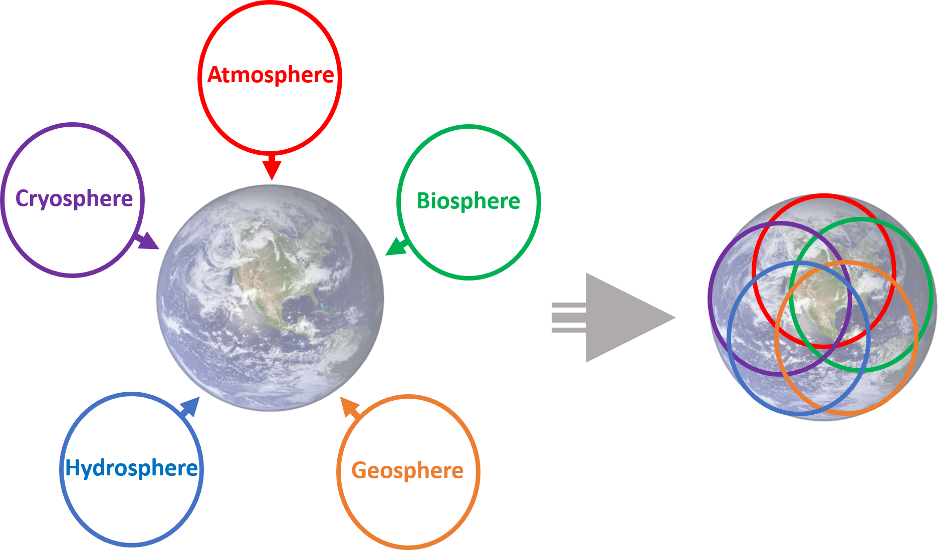
Geology is an umbrella science that encompasses all biological, chemical, and physical processes that act on the planet and make up our world. In the same way that the human body can be divided into systems (circulatory, digestive, endocrine, etc.), the Earth can be described as a complex entity that encompasses many different systems all acting on one another. There are 5 main systems, or spheres, found on Earth: geosphere, biosphere, hydrosphere, atmosphere, and cryosphere.
Geosphere ("geo" = Earth)
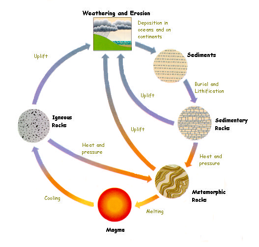
The geosphere encompasses all physical material that makes up the interior and surface of the Earth. This includes all rocks and minerals, but is also includes the active processes that link these rocks and minerals together. While many tend to focus on the three types of rocks: igneous, sedimentary, and metamorphic, the forces of plate tectonics and weathering actively change rocks from one type to another. This system is referred to as the Rock Cycle. This is the focus of most physical geology courses and will be the main framework for this text. Because the geosphere describes the physical structure of the Earth, it is integral to all other spheres as well.
Biosphere ("bio" = life)

The biosphere is made up of all living things, as well as the ecosystems that support that life. Obviously, life can be found in many different places, from the tops of mountains to the bottoms of oceans, in wet and dry places, in cold and hot environments. The biosphere therefore overlaps and interacts with all other spheres.
Hydrosphere ("hydro" = water)
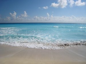
The Earth has been described as the “Blue Marble” in space due to the presence of enormous amounts of water on its surface. All of the liquid water found on earth makes up the hydrosphere. As water flows on the Earth’s surface, it changes landscapes and nourishes life, and interacts with all other spheres.
Atmosphere ("atmo" = vapor)
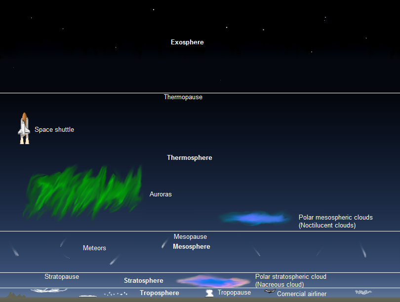
All of the gases that circulate around and surround the earth are a part of the atmosphere. This includes the air we breathe, the gases that are responsible for global weather and climate, as well as the ones that burn up meteorites as they plummet toward the Earth’s surface. The atmosphere is further broken into layers: troposphere, stratosphere, mesosphere, thermosphere, and exosphere.
Cryosphere ("cryo" = frozen)
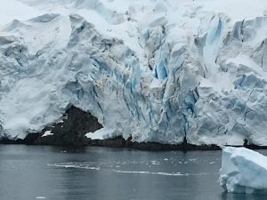
Cryo- comes from a Greek word meaning "frost." The cryosphere encompasses all of frozen water on the Earth. Typically found at high elevations and at the poles, ice can have dramatic impacts on landscapes (geosphere), provide sources of liquid water (hydrosphere), and support ecosystems for living things (biosphere).
Integrated systems
While it is easier to look at each system independently, they are all integrated on the Earth. Each one is constantly acting and interacting with another on our dynamic planet.
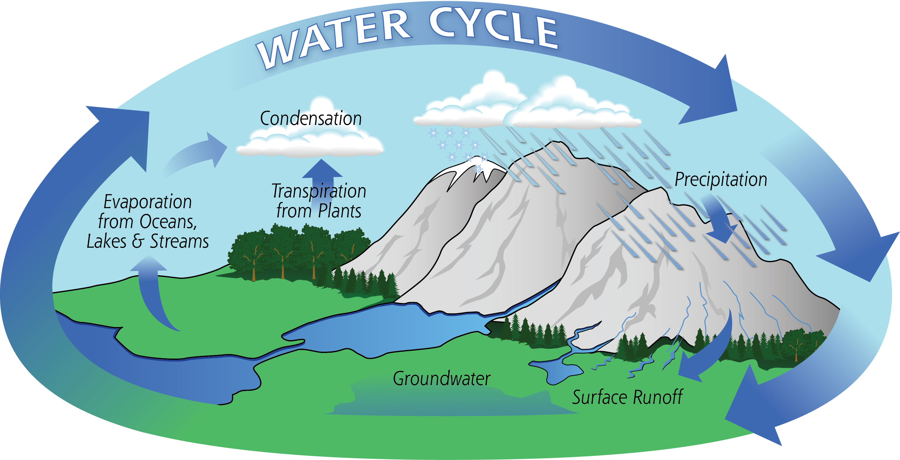
H2O, or the water molecule, is constantly changing. It is the only substance on Earth that is present in all states of matter - solid, liquid, and gas. The cycling of water throughout the Earth, also called the hydrologic cycle, describes how water moves through various environments on Earth. The largest reservoir of water is in the ocean, and it exists there as a liquid. Through the process of evaporation, it becomes a gas. At that point, it may crystallize as a solid (snow or ice) and deposit on land. It could then melt, forming a liquid again, and run off the landforms, eternally shaping the Earth. It can be taken up into plants, aiding in photosynthesis, and released as a gas through the process of transpiration. The possibilities of pathways for water to travel on Earth are endless.
 Backyard Geology: Spheres intersect for one of the 7 Natural Wonders of the World
Arizona is known as the "Grand Canyon State" because of the dramatic landscape that unfolds at the intersection of brightly colored flat-lying sedimentary rocks and a dynamic river system. This landscape evolved over millions of years while the underlying rocks were uplifted by Plate Tectonics, and the Colorado River cut down through soft sedimentary rocks..
***See 1.5 for Text and Media Attributions
earthquakes that precede larger earthquakes in the same location
The study and monitoring of volcanoes.
As previously discussed in section 3.9, a rock is a collection of consolidated minerals. Rocks are grouped into three main categories based on how they form:
- Igneous: formed from the cooling and crystallization of molten rock.
- Sedimentary: formed when weathered fragments of other rocks are buried, compressed, and cemented together, or when minerals precipitate directly from solution
- Metamorphic: formed by alteration (due to heat, pressure, and/or chemical action) of a pre-existing igneous or sedimentary rock

The focus of this chapter is on Igneous rocks, though it is important to remember this is just a piece of the rock cycle. In figure 4.0.1, the entire rock cycle is shown, as well as highlighting just eh igneous rock portion of the cycle.
Learning Objectives
After carefully reading this chapter, completing the exercises within it, and answering the questions at the end, you should be able to:
- Describe the rock cycle and the types of processes that lead to the formation of igneous, sedimentary, and metamorphic rocks, and explain why there is an active rock cycle on Earth.
- Explain the concept of partial melting and describe the geological processes that lead to melting.
- Describe, in general terms, the range of chemical compositions of magmas.
- Discuss the processes that take place during the cooling and crystallization of magma, and the typical order of crystallization according to the Bowen reaction series.
- Explain how magma composition can be changed by fractional crystallization and partial melting of the surrounding rocks.
- Apply the criteria for igneous rock classification based on mineral proportions.
- Describe the origins of phaneritic, porphyritic, and pegmatitic rock textures.
- Identify plutons on the basis of their morphology and their relationships to the surrounding rocks.
- Explain the origin of a chilled margin.
As previously discussed in section 3.9, a rock is a collection of consolidated minerals. Rocks are grouped into three main categories based on how they form:
- Igneous: formed from the cooling and crystallization of molten rock.
- Sedimentary: formed when weathered fragments of other rocks are buried, compressed, and cemented together, or when minerals precipitate directly from solution
- Metamorphic: formed by alteration (due to heat, pressure, and/or chemical action) of a pre-existing igneous or sedimentary rock


The focus of this chapter is on Igneous rocks, though it is important to remember this is just a piece of the rock cycle.
Learning Objectives
After carefully reading this chapter, completing the exercises within it, and answering the questions at the end, you should be able to:
- Describe the rock cycle and the types of processes that lead to the formation of igneous, sedimentary, and metamorphic rocks, and explain why there is an active rock cycle on Earth.
- Explain the concept of partial melting and describe the geological processes that lead to melting.
- Describe, in general terms, the range of chemical compositions of magmas.
- Discuss the processes that take place during the cooling and crystallization of magma, and the typical order of crystallization according to the Bowen reaction series.
- Explain how magma composition can be changed by fractional crystallization and partial melting of the surrounding rocks.
- Apply the criteria for igneous rock classification based on mineral proportions.
- Describe the origins of phaneritic, porphyritic, and pegmatitic rock textures.
- Identify plutons on the basis of their morphology and their relationships to the surrounding rocks.
- Explain the origin of a chilled margin.
As previously discussed in section 3.9, a rock is a collection of consolidated minerals. Rocks are grouped into three main categories based on how they form:
- Igneous: formed from the cooling and crystallization of molten rock.
- Sedimentary: formed when weathered fragments of other rocks are buried, compressed, and cemented together, or when minerals precipitate directly from solution
- Metamorphic: formed by alteration (due to heat, pressure, and/or chemical action) of a pre-existing igneous or sedimentary rock

The focus of this chapter is on Igneous rocks, though it is important to remember this is just a piece of the rock cycle. In figure 4.0.1, the entire rock cycle is shown, as well as highlighting just eh igneous rock portion of the cycle.
Learning Objectives
After carefully reading this chapter, completing the exercises within it, and answering the questions at the end, you should be able to:
- Describe the rock cycle and the types of processes that lead to the formation of igneous, sedimentary, and metamorphic rocks, and explain why there is an active rock cycle on Earth.
- Explain the concept of partial melting and describe the geological processes that lead to melting.
- Describe, in general terms, the range of chemical compositions of magmas.
- Discuss the processes that take place during the cooling and crystallization of magma, and the typical order of crystallization according to the Bowen reaction series.
- Explain how magma composition can be changed by fractional crystallization and partial melting of the surrounding rocks.
- Apply the criteria for igneous rock classification based on mineral proportions.
- Describe the origins of phaneritic, porphyritic, and pegmatitic rock textures.
- Identify plutons on the basis of their morphology and their relationships to the surrounding rocks.
As previously discussed in section 3.9, a rock is a collection of consolidated minerals. Rocks are grouped into three main categories based on how they form:
- Igneous: formed from the cooling and crystallization of molten rock.
- Sedimentary: formed when weathered fragments of other rocks are buried, compressed, and cemented together, or when minerals precipitate directly from solution
- Metamorphic: formed by alteration (due to heat, pressure, and/or chemical action) of a pre-existing igneous or sedimentary rock

The focus of this chapter is on Igneous rocks, though it is important to remember this is just a piece of the rock cycle. In figure 4.0.1, the entire rock cycle is shown, as well as highlighting just eh igneous rock portion of the cycle.
Learning Objectives
After carefully reading this chapter, completing the exercises within it, and answering the questions at the end, you should be able to:
- Describe the rock cycle and the types of processes that lead to the formation of igneous, sedimentary, and metamorphic rocks, and explain why there is an active rock cycle on Earth.
- Explain the concept of partial melting and describe the geological processes that lead to melting.
- Describe, in general terms, the range of chemical compositions of magmas.
- Discuss the processes that take place during the cooling and crystallization of magma, and the typical order of crystallization according to the Bowen reaction series.
- Explain how magma composition can be changed by fractional crystallization and partial melting of the surrounding rocks.
- Apply the criteria for igneous rock classification based on mineral proportions.
- Describe the origins of phaneritic, porphyritic, and pegmatitic rock textures.
- Identify plutons on the basis of their morphology and their relationships to the surrounding rocks.
Waves
Waves form on the ocean and lakes because energy from the wind is transferred to the water. The stronger the wind, the longer it blows, and the larger the area of water over which it blows (the fetch), the larger the waves are likely to be.
The essential parameters of a wave are its wavelength (the horizontal distance between two crests or two troughs), its amplitude (the vertical distance between a trough and a crest), and its velocity (the speed at which wave crests move across the water). Relatively small waves move up to about 10 km/h and arrive on a shore about once every 3 seconds. Huge waves move about five times faster (over 50 km/h), but because their wavelengths are so much longer, they arrive less often – about once every 14 seconds. (4)
As a wave moves across the water's surface, the water itself mostly moves up and down and only moves a small amount in the direction of wave motion. As this happens, a point on the water surface describes a circle with a diameter equal to the wave amplitude. This motion is also transmitted to the water underneath, and the water is disturbed by a wave to a depth of approximately one-half of the wavelength. (1)
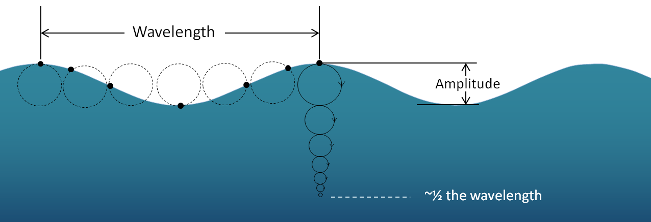
The one-half wavelength depth of disturbance of the water beneath a wave is known as the wave base. Since ocean waves rarely have wavelengths higher than 200 m, and the open ocean is several thousand meters deep, the wave base does not frequently interact with the ocean's bottom. However, as waves approach the much shallower water near the shore, they start to "feel" the bottom, and they are affected by that interaction. The wave "orbits" are both flattened and slowed by dragging, and the implications are that the wave amplitude (height) increases, and the wavelength decreases (the waves become much steeper). The ultimate result of this is that the waves lean forward, and eventually break. (4)

Shoreline Currents
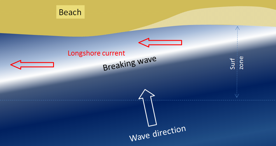
Waves usually approach the shore at an angle, and this means that one part of the wave feels the bottom sooner than the rest of it, so the part that feels the bottom first slows down first. In open water, these waves had wavelengths close to 100 m. In the shallow water closer to shore, the wavelengths decreased to around 50 m, and in some cases, even less. Even though they bend and become nearly parallel to the shore, most waves still reach the shore at a small angle, and as each one arrives, it pushes water along the shore, creating what is known as a longshore current within the surf zone where waves are breaking. (3)
Another significant effect of waves reaching the shore at an angle is that when they wash up onto the beach, they do so at an angle, but when that same wave water washes back down the beach, it moves straight down the slope of the beach. Figure 8.2.2 shows the upward-moving water, known as the swash, pushes sediment particles along the beach, while the downward-moving water, the backwash, brings them straight back. With every wave that washes up and down the beach, particles of sediment are moved along the beach in a zigzag pattern. (1)
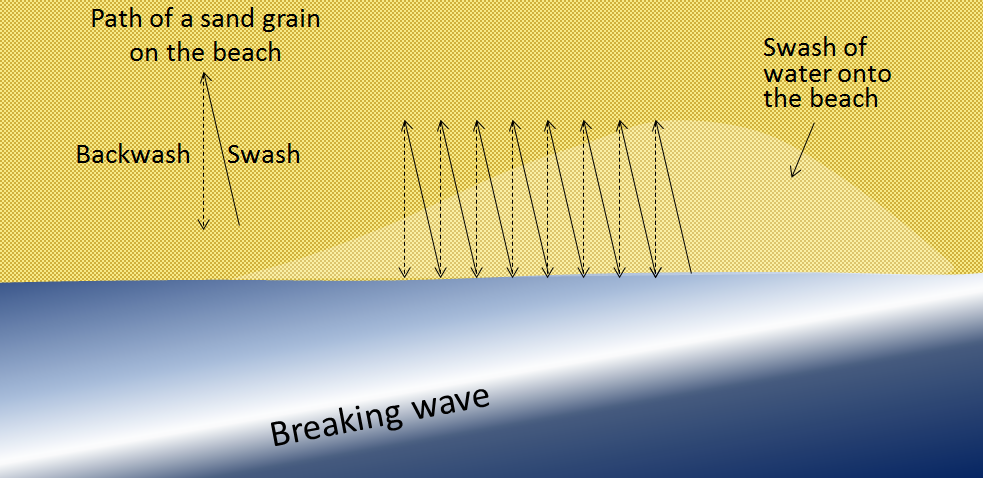
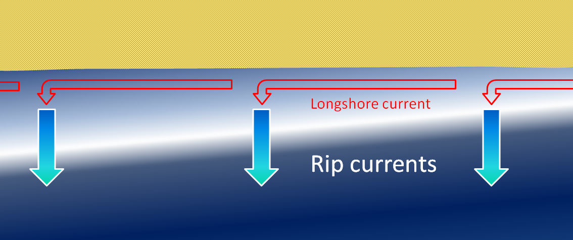
The combined effects of sediment transport within the surf zone by the longshore current and sediment movement along the beach by swash and backwash is known as longshore drift. Longshore drift moves a tremendous amount of sediment along coasts (both oceans and large lakes) around the world, and it is responsible for creating a variety of depositional features. A rip current is another type of current that develops in the nearshore area and has the effect of returning water that has been pushed up to the shore by incoming waves. If part of a beach does not have a strong unidirectional longshore current, the rip currents may be fed by longshore currents going in both directions. (1)
Hazards associated with Waves and Currents
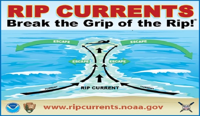
Any place where the ocean and land are in contact can pose a risk of hazard to people. Rip currents flow straight out from the shore and are fed by the longshore currents. They die out quickly outside the surf zone but can be dangerous to swimmers who get caught in them. Typically they reach speeds of 1 to 2 feet per second, but some have been measured at 8 feet per second, faster than an Olympic swimmer. Because rip currents move perpendicular to shore and can be very strong, beach swimmers need to be careful. A person caught in a rip can be swept away from shore very quickly. The best way to escape a rip current is by swimming parallel to the shore instead of towards it, since most rip currents are less than 80 feet wide. A swimmer can also let the current carry him or her out to sea until the force weakens, because rip currents stay close to shore and usually dissipate just beyond the line of breaking waves. Occasionally, however, a rip current can push someone hundreds of yards offshore. The most important thing to remember if you are ever caught in a rip current is not to panic. Continue to breathe, try to keep your head above water, and don’t exhaust yourself fighting against the force of the current. (6)
Storm Surge
Some of the damage done by storms is from storm surges. The water piles up at a shoreline as storm winds push waves into the coast. Storm surge may raise sea level as much as 7.5 m (25 ft), which can be devastating in a shallow land area when winds, waves, and rain are heavy. Storm surges can cause extensive damages, eroding beaches and coastal highways, destroying buildings and boats, and affecting inland rivers and lakes.
Tsunamis
A particular type of wave is generated by an energetic event affecting the seafloor, such as earthquakes, submarine landslides, and volcanic eruptions. Called tsunamis, these waves are created when a portion of the seafloor is suddenly elevated by movement in the crustal rocks below that are involved in an earthquake. The water is suddenly lifted, and a wave train spreads out in all directions from the mound carrying enormous energy and traveling very fast (hundreds of miles per hour). A series of long-period waves (on the order of tens of minutes) that are usually generated by an impulsive disturbance that displaces massive amounts of water, such as an earthquake occurring on or near the sea floor. Underwater volcanic eruptions and landslides can also cause tsunami. The resultant waves much the same as waves propagating in a calm pond after a rock is tossed. While traveling in the deep oceans, tsunami have extremely long wavelengths, often exceeding 50 nm, with small amplitudes (a few tens of centimeters) and negligible wave steepness, which in the open ocean would cause nothing more than a gentle rise and fall for most vessels, and possibly go unnoticed. Tsunami travel at very high speeds, sometimes in excess of 400 knots. Across the open oceans, these high-speed waves lose very little energy. As tsunami reach the shallow waters near the coast, they begin to slow down while gradually growing steeper, due to the decreasing water depth, much in the same way that wind waves form (Figure 14.2.1). The building walls of destruction can become extremely large in height, reaching tens of meters or more as they reach the shoreline. The effects can be further amplified where a bay, harbor, or lagoon funnels the waves as they move inland. Large tsunami have been known to rise to over 100 feet! The amount of water and energy contained in tsunami can have devastating effects on coastal areas. (6)

