"

1.2 Evidence for Plate Tectonics

In the reading, we learned about the long scientific journey of gathering evidence that shifted the hypotheses of continental drift and seafloor spreading into the unified theory of Plate Tectonics. But what exactly is that evidence, and what makes the idea of Plate Tectonics good enough to become a scientific theory? We will find out in this section!

Fossil evidence that the world's continents were once assembled in a different area of the world, where the fossils for specific species span across continents that are now oceans apart. Examples include the reptiles Cynognathus, Mesosaurus, and Lystrosaurus and the plant Glossopteris
Figure 1.2.1 Fossil evidence that the world’s continents were once assembled in different areas of the world. Image Public Domain, Wikimedia Commons, by USGS

Recall that seafloor spreading occurs at Mid-Ocean ridges, where there is a Divergent plate boundary. When a plume of hot magma rises up to the surface at this boundary, brand new oceanic crust is born, and the older crust is shifted to the side, as though it were on a crustal “conveyor belt”. Perhaps the strongest evidence for this idea of seafloor spreading can be found in the record of magnetic striping. Learn about it below!

Plate Movement Over Time

Because the plates can move, our continents and oceans have not always looked the way they do today!  Let’s have a look!

All of the continents as we know them today are stuck together in the center of the map as a single landmass known as "Pangaea" in the Triassic Era
Figure 1.2.2 The Triassic Period (ca. 250 Ma) map of the world. Image by Eikeskog1225, CC BY-SA 4.0 Wikimedia Commons


Above is a map of what the world looked like about 250 million years ago (note: “Ma” means “mega-anon” or million years ago).

By viewing some of Earth’s past maps in chronological order, we can better visualize how the ancient plates moved. Let’s look at 150 million years of Earth’s history below…
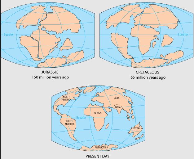
3 World Maps from the Jurassic (150 Ma), Cretaceous (65 Ma), and Present Day, in which continents are breaking up in the Jurassic and India is its own separate continent,. In the Cretaceous the continents are further broken up and India is heading North towards Asia.
Figure 1.2.3 Break up of Pangaea from 150 Ma to Present. Image by Kious, Jacquelyne; Tilling, Robert I.; Kiger, Martha, Russel, Jane, USGS, Public Domain at Wikimedia Commons.

Summing It Up: The Wilson Cycle

Let’s review the configuration of the continents in Earth’s past, present, and future one more time. There is a pattern in which supercontinents form, break up, then form once again. This pattern is called the Wilson Cycle. To give you an idea of this cycle, here is what the world map will look like in about 250 Million years below!


All the world's continents will eventually come together again in the center of the planet in what is called "Pangaea Ultima" or Pangaea Proxima.
Figure 1.2.4 An approximation of what Earth will look like in 250 Ma. Image by Orolenial, Wikimedia Commons, CC BY-SA 3.0

License

Icon for the Creative Commons Attribution-NonCommercial-ShareAlike 4.0 International License

Exploring Physical Geology Lab Online Copyright © 2022 by Charlene Estrada is licensed under a Creative Commons Attribution-NonCommercial-ShareAlike 4.0 International License, except where otherwise noted.