13.1 Soil Formation and Classification
Katherine J. Megivern
Soil Formation and Classification
Soil forms from the top down and from the bottom up. What does that mean? Consider this:
1) Soil forms through the accumulation and decay of organic matter. This is the top-down part because most organic material accumulates at and near Earth’s surface.
AND
2) Soil also forms through the mechanical and chemical weathering processes acting on rock. This is the bottom-up part.
Video13.1.1. (4:10) Primary Ecological Succession in Soil Formation. This video takes a closer look at soil formation from the top down and from the bottom up. Note that the acid of lichens breaking down rock is forming soil from the bottom up. The organic material of lichens when they die is adding to soil from the top down.
The factors that affect the nature of soil and the rate of its formation include weathering, climate (especially average temperature and precipitation amounts, and the resulting types of vegetation), the type of parent material, the slope of the surface, and the amount of time available.
Weathering
Weathering is a vital part of the process of soil formation. Weathering includes the mechanical (physical) breakup of rocks and the chemical weathering (or breaking down) of minerals. The types of weathering that take place within a region have a significant influence on soil composition and texture.
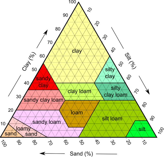
Soil scientists describe soil texture in terms of the relative proportions of sand, silt, and clay. See Figure 13.1.1 below. In this diagram, sand particles are the largest of the three; clay particles are the smallest and are flat. The sand and silt components in this diagram are dominated by quartz, with lesser amounts of feldspar and rock fragments, while the clay minerals dominate the clay component. In a warm climate, chemical weathering dominates, and soils tend to be more abundant in clay.

Video 13.1.2. Understanding Soil Types and Soil Texture. (9:01) The video below starts with a good intro (0:00-0:32) followed by a demonstration on how to figure out sand, silt, and clay percentages in a soil sample (0:32-5:12). The intro and 5:12-9:00 (approximately the last half of the video) are probably the most relevant for most readers and will help you answer questions at the end of this section.
Climate
The downward percolation of water facilitates soil development. Soil forms most readily under temperate to tropical conditions (not cold), and where precipitation amounts are moderate (not dry, but not too wet). Chemical weathering reactions (especially the formation of clay minerals) and biochemical reactions proceed fastest under warm conditions, and plant growth is enhanced in warm climates. Too much water (e.g., in rainforests) can lead to the leaching of critical chemical nutrients and, hence, acidic soils. In humid and poorly drained regions, swampy conditions may prevail, producing soil that is dominated by organic matter. Too little water (e.g., in deserts and semi-deserts), results in minimal downward chemical transportation, and the accumulation of salts and carbonate minerals (e.g., calcite) from upward-moving water. Soils in dry regions also suffer from a lack of organic material.
Parent Material
Soil parent materials can include all different bedrock types and any unconsolidated sediments, such as glacial deposits and stream deposits. Soils are described as residual soils if they develop on bedrock, and transported soils if they develop on transported material such as glacial sediments. However, the term “transported soil” is misleading because it implies that the soil itself has been transported, which is not the case. When referring to such soil, it is better to be specific and say “soil developed on unconsolidated material,” because that distinguishes it from soil developed on bedrock.
Parent materials provide essential nutrients to residual soils. For example, a minor constituent of granitic rocks is the calcium-phosphate mineral apatite, which is a source of the critical soil nutrient phosphorus. Basaltic parent material tends to generate very fertile soils because it also provides phosphorus, along with significant amounts of iron, magnesium, and calcium.
Some unconsolidated materials, such as river-flood deposits, make for especially good soils because they tend to be rich in clay minerals. Clay minerals have large surface areas with negative charges that are attractive to positively charged elements like calcium, magnesium, iron, and potassium, which are essential nutrients for plant growth.
Slope
Soil can only develop where surface materials remain in place and are not frequently moved away by mass wasting. Soils cannot develop where the rate of soil formation is less than the rate of erosion, so steep slopes tend to have little or no soil.
Time
Even under ideal conditions, soil takes thousands of years to develop. Virtually all of northern North America was still glaciated up until 14 ka (14,000 years ago). Glaciers still dominated the central and northern parts of Canada until around 10 ka, and so, at that time, conditions were still not ideal for soil development even in the southern regions. Therefore, soils in Canada, and especially in central and northern Canada, are relatively young and not well developed.
The same applies to soils forming on newly created surfaces, such as recent deltas or sandbars, or in areas of mass wasting.
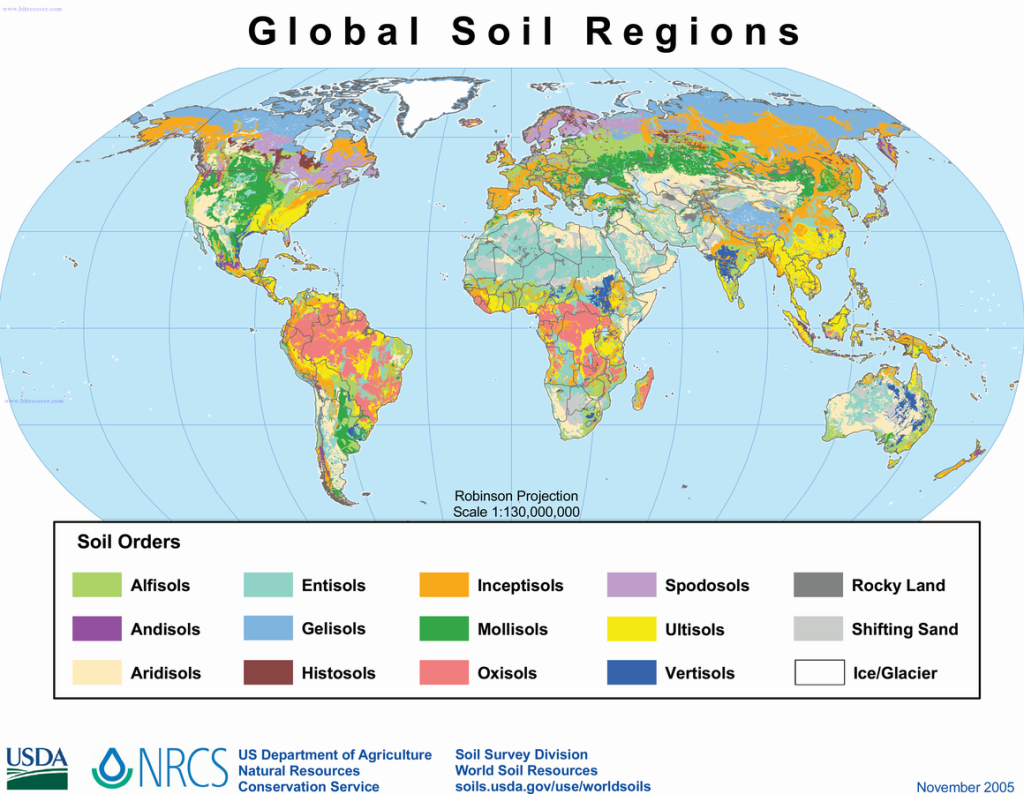
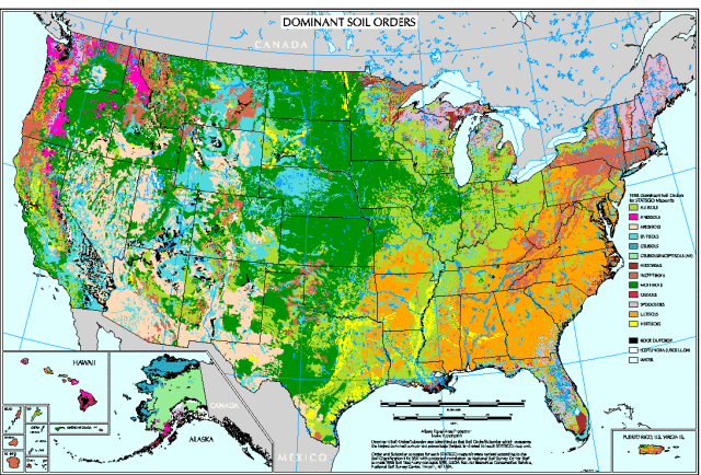
There are other soil classification tools in addition to the soil texture triangle for sand, silt, and clay content. One is the Natural Resources Conservation Service (NRCS)/USDA 12 Orders of Soil Taxonomy, which takes into consideration complete soils, encompassing the organic as well as the inorganic components. There are thousands of different types of soils in the world, and every one is covered by this 12-order classification.
Click on this link to view a high-resolution color poster of these 12 orders that includes a brief description of each. It is highly unlikely that these order names are familiar to you, but they are simply derived from dominant soil characteristics of each order such as plant type, rock type from which the soil was formed, or a certain climate characteristic. View their global distribution in Figure 3.1.3, and in Figure 3.1.4, a more detailed look at soils distribution in the U.S.


Humans classify things, and soil is no exception. The simple 12 Orders of Soil Taxonomy has many subdivisions within each category, comparable to biological classification of organisms with kingdoms, domains, orders, and so on.
And the USDA NRCS Web Soil Survey is an amazing interactive tool that offers detailed information on the many, many named specific soils across the U.S. Try it out! Compare soils here with soils somewhere quite far from here!
A very common rock-forming silicate mineral with formula SiO2.
A group of silicate minerals which represents the most abundant mineral class of the continental crust.
chemical reactions that take place within living cells
the material on which soil forms
the solid rock beneath loose material
The process in which rock, soil, or sediment moves down a slope under the force of gravity. Mass wasting is an umbrella term that includes hazards such as landslides, debris flows, rock falls, and mudslides.

