
5.5 Forecasting and Mitigating Earthquakes
Merry Wilson
Prediction
It has long been a dream of seismologists, geologists, and public safety officials, to be able to accurately predict the location, magnitude, and timing of earthquakes on time scales that would be useful for minimizing danger to the public and damage to infrastructure (e.g., weeks, days, hours). Many different avenues of prediction have been explored, such as using observations of warning foreshocks, changes in magnetic fields, seismic tremor, changing groundwater levels, strange animal behavior, observed periodicity, stress transfer considerations, and others. So far, none of the research into earthquake prediction has provided a reliable method. Although there are some reports of successful earthquake predictions, they are rare, and many are surrounded by doubtful circumstances. (5)
The problem with earthquake predictions, as with any other type of prediction, is that they have to be accurate most of the time, not just some of the time. We have come to rely on weather predictions because they are generally (and increasingly) accurate. But if we try to predict earthquakes and are only accurate 10% of the time (and even that isn’t possible with the current state of knowledge), the public will lose faith in the process very quickly, and then will ignore all of the predictions. Efforts are currently focused on forecasting earthquake probabilities, rather than predicting their occurrence. (5)
There was great hope for earthquake predictions late in the 1980s when attention was focused on part of the San Andreas Fault at Parkfield, about 200 kilometers south of San Francisco. Between 1881 and 1965 there were five earthquakes at Parkfield, most spaced at approximately 20-year intervals, all confined to the same 20 kilometer-long segment of the fault, and all very close to M6. Both the 1934 and 1966 earthquakes were preceded by small foreshocks exactly 17 minutes before the main quake.
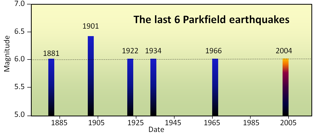
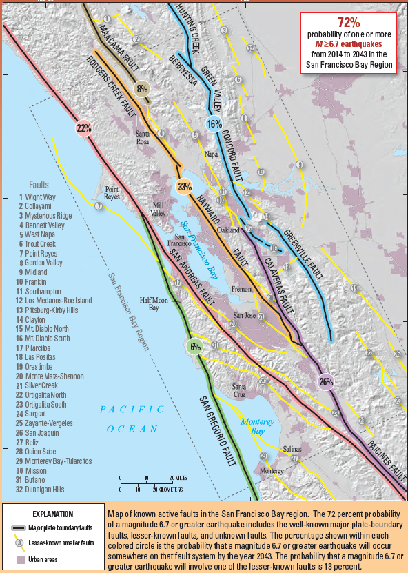
The hope for earthquake prediction is not dead, but it was hit hard by the Parkfield experiment. The current focus in earthquake-prone regions is to provide forecasts of the probability of an earthquake of a certain magnitude within a certain time period—typically a number of decades—while officials focus on ensuring that the population is educated about earthquake risks and that buildings and other infrastructure are as safe as can be. An example of this approach for the San Francisco Bay region of California is shown in the adjacent figure. Based on a wide range of information, including past earthquake history, accumulated stress from plate movement, and known stress transfer, seismologists and geologists have predicted the likelihood of a M6.7 or greater earthquake on each of eight major faults that cut through the region (Fig. 5.5.2). The greatest probabilities are on the Hayward, Rogers Creek, Calaveras, and San Andreas Faults. As shown, there is a 72% chance that a major and damaging earthquake will take place somewhere in the region prior to 2043. (5)
As we’ve discussed already, it’s not sufficient to have strong building codes, they have to be enforced. Building code compliance is quite robust in most developed countries, but is sadly inadequate in many developing countries.
Mitigation
The best we can do with earthquake hazard mitigation is work on engineering manmade structures to withstand shaking, research and understand earthquake occurrence, create early warning systems, and educate the population.
Engineering Design
Earthquakes do not kill people; falling buildings and highways kill people. History has taught us the importance of building codes to create safer buildings. Many of the massive death tolls reported by earthquakes are caused by poorly built buildings rather than the earthquake itself. In general, buildings or structures built out of brick, stone, mud, or reinforced concrete fair poorly in large earthquakes because there is very little flexibility in the structures as the ground shakes. The best types of buildings to be in are those built of wood because of their flexibility; the house may not be habitable after the earthquake, but they won’t crumble or collapse on people. Buildings with weak floors or basement garages are also susceptible to collapsing. (4)
There are several techniques engineers have developed to help buildings withstand the destructive power of earthquakes. Many buildings are being built or retrofitted with diagonal braces that can withstand the ground motions caused by an earthquake. Tall buildings also tend to sway at different frequencies them to slam into each other during an earthquake. If engineers know how much a building will sway, they can determine how far apart buildings must be built. Finally, engineers are placing rubber pads at the base of newly built and retrofitted buildings that act as shock absorbers. (4)
Early Warning Systems
A few seconds could mean all the difference between life and death during an earthquake. ShakeAlert is an earthquake early warning (EEW) system that detects significant earthquakes so quickly that alerts can reach many people before shaking arrives. ShakeAlert is not earthquake prediction, rather a ShakeAlert Message indicates that an earthquake has begun and shaking is imminent. It is a product of the USGS Earthquake Hazards Program in conjunction with the regional seismic networks. Not only can this information give citizens a few extra seconds during an earthquake, it can also provide valuable near-real-time maps of ground motion and shaking intensity following significant earthquakes. These maps are used by federal, state, and local organizations, both public and private, for post-earthquake response and recovery, public and scientific information, as well as for preparedness exercises and disaster planning. (6)
Earthquake Preparedness
Everywhere in the world has disasters, so nowhere is safe. But everyone should be prepared for the type of disasters their region experiences. Everyone should have a 72 hour kit prepared in your car and house. Recently the Federal Emergency Management Agency (FEMA) stated that citizens should prepare a 5-day kit in case federal, state, and local agencies can not reach you. Learn more how you can prepare at Ready.gov. Here are a few more items you should think about with disaster preparedness (4).
- Each member in your family should also know where to meet in case of a disaster.
- The number one reason people end up in the hospital after an earthquake is glass on their feet. Having a pair of old shoes under your bed can reduce that probability.
- Know how to shut off your gas line if you smell gas in your house. If it requires a wrench to shut off, always have one next to the line for a quick shutoff. You will know if you have a gas leak because the gas companies place a chemical in the gas that will smell like rotten eggs.
- Make sure your water heater is attached to your house. If your water heater falls over and the gas line breaks, your house can catch fire.
- If you and your family are safe, take care of others in need.
- Finally, for those interested, look into getting CERT certified as a first responder.
Backyard Geology: Lake Mary Fault, Arizona
It’s important to understand all the research that goes into understanding earthquakes and helps scientists predict their potential future effects. Arizona has seen plenty of Earthquake Activity in its past! Watch the video below to see how the Lake Mary Fault shows how multiple events can create a fault zone and then determine what you can do to prepare for this type of event.
Video 5.5.1. Arizona State Geological Survey (2013). Lake Mary Fault, Arizona. CC-BY.
