
7.2 Classification of Mass Wasting
Merry Wilson
We classify slope failures so that we can understand what causes them and learn how to mitigate their effects. The three criteria used to describe slope failures are:
- Material: Type of material that failed (typically either bedrock or unconsolidated sediment)
- Motion: How the material moved (fall, slide, or flow).
- Rate: Speed at which the material moved.
Three types of motion associated with slope failure are:
- Fall: Material drops through the air, vertically or nearly vertically.
- Slide: Material moves as a cohesive mass along a sloping surface.
- Flow: Material moves like a fluid.
Unfortunately, it’s not normally that simple. Many slope failures involve two of these types of motion, some involve all three, and most times, it’s not easy to tell how the material moved. The types of slope failure that we’ll cover here are summarized in Table 7.1, though there are other types of mass wasting.
| [Skip Table] | |||
| Failure Type | Type of Material | Type of Motion | Rate of Motion |
|---|---|---|---|
| Rock fall | Bedrock | Fall | Extremely rapid |
| Rock slide | Bedrock | Slide | Very slow to extremely rapid |
| Rock avalanche | Bedrock (slides then breaks into smaller fragments) | Flow | Extremely rapid |
| Creep or solifluction | Unconsolidated materials (rock fragments, soils) | Flow or slide | Extremely slow |
| Slump | Unconsolidated sediments | Slide | Very slow to moderate |
| Mudflow | Unconsolidated sediments (very small silt and clay) | Flow | Moderate to Extremely rapid |
| Debris flow | Unconsolidated sediments (Sand, gravel, and larger fragments) | Flow | Rapid to Extremely rapid |
Rock Fall
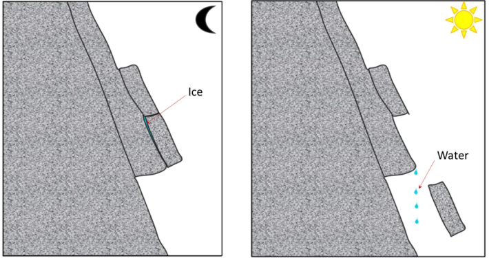
Rock fragments can break off relatively easily from steep bedrock slopes, most commonly due to frost-wedging in areas where there are many freeze-thaw cycles per year. When water freezes to form ice, its volume increases by about 8%, this causes fractures to enlarge. When the ice melts, more water can fill the larger crack, and refreeze. This process, over time, can cause large pieces of solid rock to fall (Fig 7.2.1). However, it can occur due to other triggers, particularly heavy rain, which adds weight or loosens material.
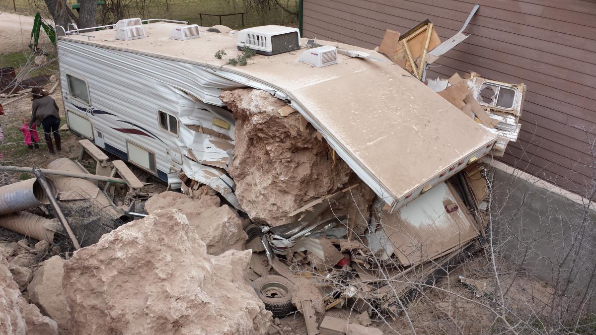
A rock fall in Verde Valley, Arizona, caused tons of solid material to fall to the valley below, destroying an RV but stopping short of hitting the house (Figure 7.2.2). Luckily, no one was hurt in this rock fall, but living at the base of a cliff can be very dangerous and a fall is likely to happen again.
Rock Slide
A rock slide is the sliding motion of rock along a sloping surface. In most cases, the movement is parallel to a fracture, bedding, or metamorphic foliation plane, and it can range from very slow to moderately fast.
On June 23, 1925, a 38 million cubic meter rock slide occurred next to the Gros Ventre River (pronounced “grow vont”) near Jackson Hole, Wyoming. Large boulders dammed the Gros Ventre River and ran up the opposite side of the valley several hundred vertical feet. The dammed river created Slide Lake, and two years later in 1927, lake levels rose high enough to destabilize the dam. The dam failed and caused a catastrophic flood that killed six people in the small downstream community of Kelly, Wyoming.

A combination of three factors caused the rock slide: 1) heavy rains and rapidly melting snow saturated the sandstone causing the underlying shale to lose its shear strength, 2) the Gros Ventre River cut through the sandstone creating an over-steepened slope, and 3) soil on top of the mountain became saturated with water due to poor drainage. The cross-section diagram shows how the parallel bedding planes between the sandstone and clay/limestone offered little friction against the slope surface as the river undercut the sandstone. Lastly, the rockslide may have been triggered by an earthquake. (3)
Rock Avalanche
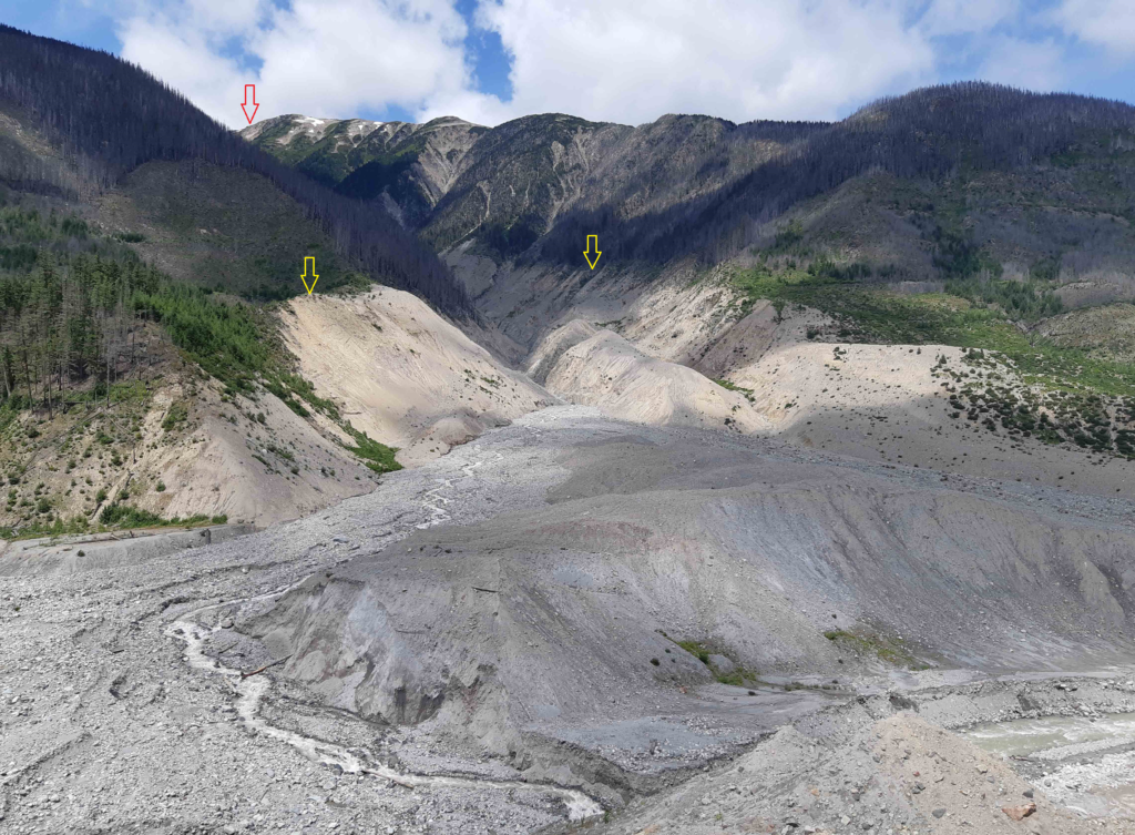
If a rock slides and then moves quickly (meters per second), the rock is likely to break into many small pieces, and at that point, it turns into a rock avalanche in which the large and small fragments of rock move in a fluid manner supported by a cushion of air within and beneath the moving mass. The 2010 slide at Mount Meager (north of Vancouver, British Columbia, Canada) was a rock avalanche, and is the largest slope failure in Canada during historical times (Figure 7.2.5). Though no one was harmed during this event, there is a great potential for damage and loss of life from this type of mass wasting. (1)
Creep or Solifluction
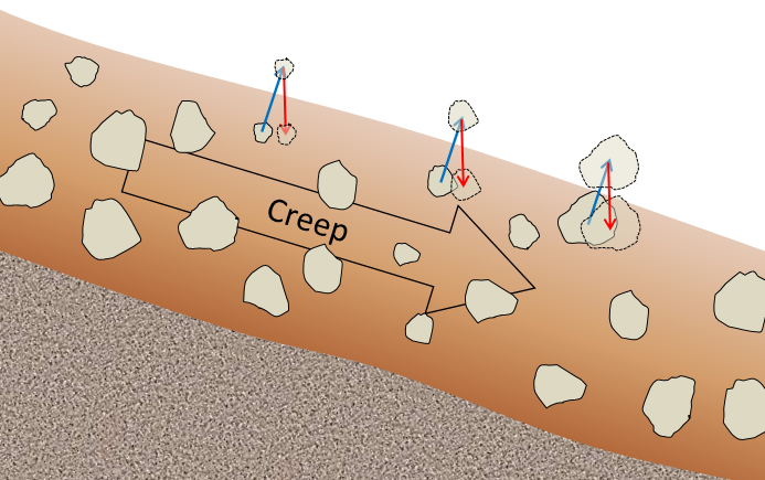
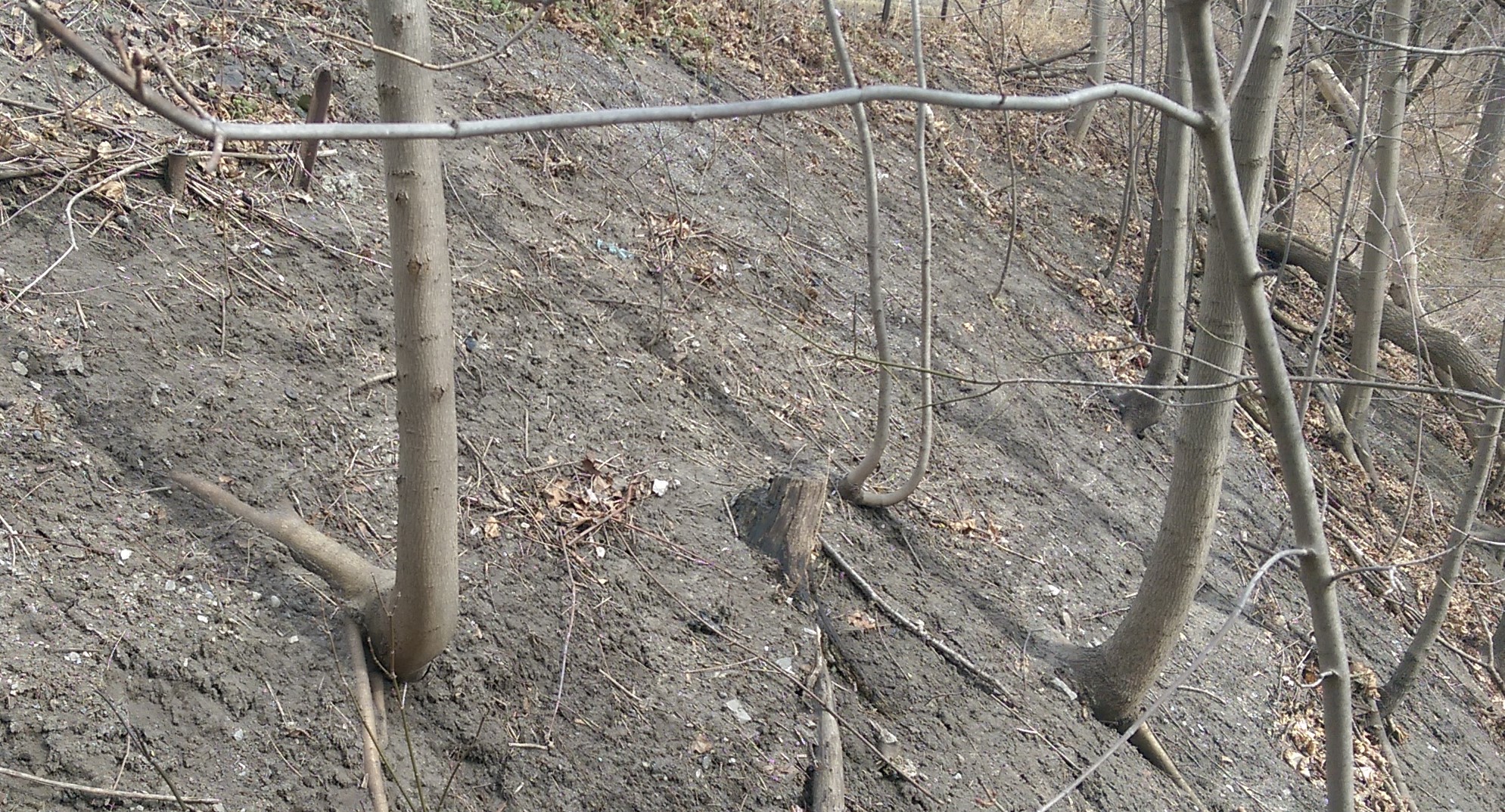
The very slow—millimeters per year to centimeters per year—movement of soil or other unconsolidated material on a slope is known as creep. Creep, which normally only affects the upper several centimeters of loose material, is typically a type of very slow flow, but in some cases, sliding may take place. Creep can be facilitated by freezing and thawing because, as shown in Figure 7.2.6, particles are lifted perpendicular to the surface by the growth of ice crystals within the soil, and then let down vertically by gravity when the ice melts. The same effect can be produced by frequent wetting and drying of the soil. In cold environments, solifluction is a more intense form of freeze-thaw-triggered creep. Creep is most noticeable on moderate-to-steep slopes where trees, fence posts, or grave markers are consistently leaning in a downhill direction. With trees, they try to correct their lean by growing upright, and this leads to a curved lower trunk, shown on Figure 7.2.7.
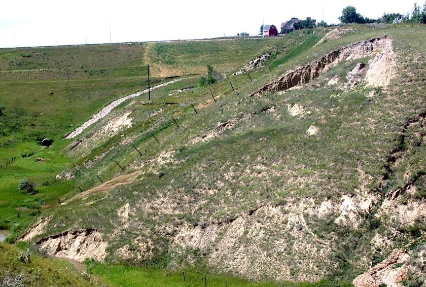
Slump

Slump is a type of slide (movement as a mass) that takes place within thick unconsolidated deposits (typically thicker than 10 meters). Slumps involve movement along one or more curved failure surfaces, with downward motion near the top and outward motion toward the bottom (Figure 7.2.8). They are typically caused by an excess of water within these materials on a steep slope.
An example of a slump in the Lethbridge area of Alberta is shown in Figure 7.2.9. This feature has likely been active for many decades and moves a little more whenever there are heavy spring rains and significant snowmelt runoff. The toe of the slump is failing because it has been eroded by the small stream at the bottom.
Mudflows and Debris Flows

As you saw previously, when a mass of sediment becomes completely saturated with water, the mass loses strength, to the extent that the grains are pushed apart, and it will flow, even on a gentle slope. This can happen during rapid spring snowmelt or heavy rains, and is also relatively common during volcanic eruptions because of the rapid melting of snow and ice. (A mudflow or debris flow on a volcano or during a volcanic eruption is a lahar.) If the material involved is primarily sand-sized or smaller, it is known as a mudflow, such as the one shown in Figure 7.2.10.
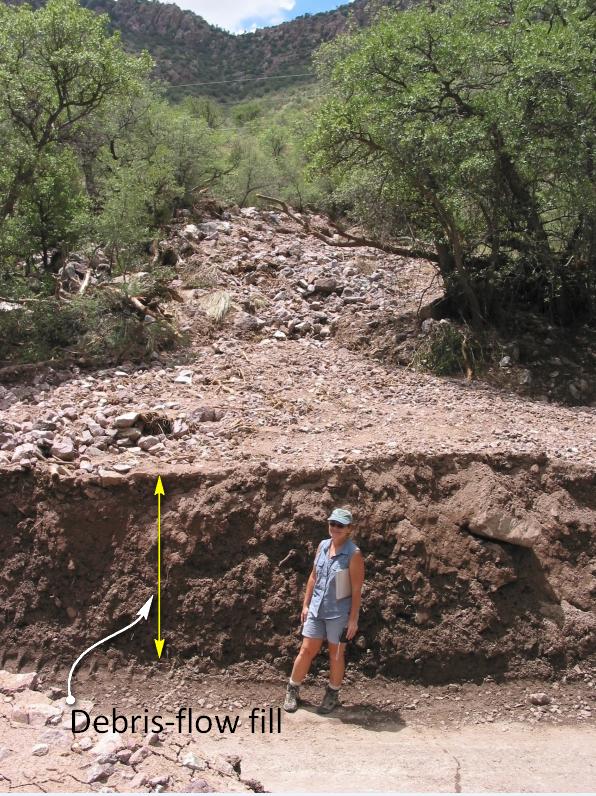
If the material involved is gravel-sized or larger, it is known as a debris flow. Because it takes more gravitational energy to move larger particles, a debris flow typically forms in an area with steeper slopes and more water than does a mudflow. In many cases, a debris flow takes place within a steep stream channel, and is triggered by the collapse of bank material into the stream. This creates a temporary dam, and then a major flow of water and debris when the dam breaks. Large amounts of debris can be carried.
motion when material drops through the air, vertically or nearly vertically
material moves as a mass along a sloping surface
material moves like a fluid
The strength of a material parallel to the direction of force.
layering formed in sedimentary rocks that forms due to flatly deposited sediments
A mudflow, or type of mass movement, that is a mixture of water, ash, rock, sediment, and debris that rapidly and suddenly moves downslope. Lahars are a commonly associated hazard with volcanic eruptions.
