
5.4 Earthquake Hazards and Risk
Merry Wilson
Hazards
Earthquakes generate a multitude of associated hazards. Some are related to the underlying geology of the area and intensity and duration of shaking, while human built structures make others worse. Some are a combination of effects.
Shaking Intensity, Duration, and Underlying Geology
It seems intuitive, but more significant shaking and duration of shaking will cause more destruction than less shaking and shorter shaking. In addition, intensity can be affected by resonance. Resonance is when the frequency of seismic energy matches a building’s natural frequency of shaking, determined by properties of the building, and intensifies the shaking’s amplitude. This famously happened in the 1985 Mexico City Earthquake, where buildings of heights between 6 and 15 stories were especially vulnerable to earthquake damage. Skyscrapers designed with earthquake resilience have dampers, and base isolation features to reduce resonance. Changes in the structural integrity of a structure could alter its resonance. Conversely, changes in measured resonance can indicate potential changes in structural integrity. (1)
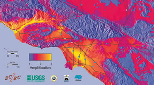
Amplification can also occur depending on the material in the subsurface (Figure 5.4.1). Amplification refers to the levels of shaking that may be increased by softness of the surface rocks, topography, and thickness of surface sediments. The image below shows the potential amplification predicted in the Los Angeles region.

Another good example of this is in the Oakland area near San Francisco, where parts of a two-layer highway built on soft sediments collapsed during the 1989 Loma Prieta earthquake (Fig. 5.4.2). At least two properties of the Earth’s crust conspired to cause this collapse: it was built on loose soils that shook much more strongly than surrounding regions on stronger ground, and variations in the thickness of the Earth’s crust between the epicenter of the Loma Prieta earthquake in the Santa Cruz Mountains and Oakland actually focused energy toward Oakland and downtown San Francisco. (5)

Building Design
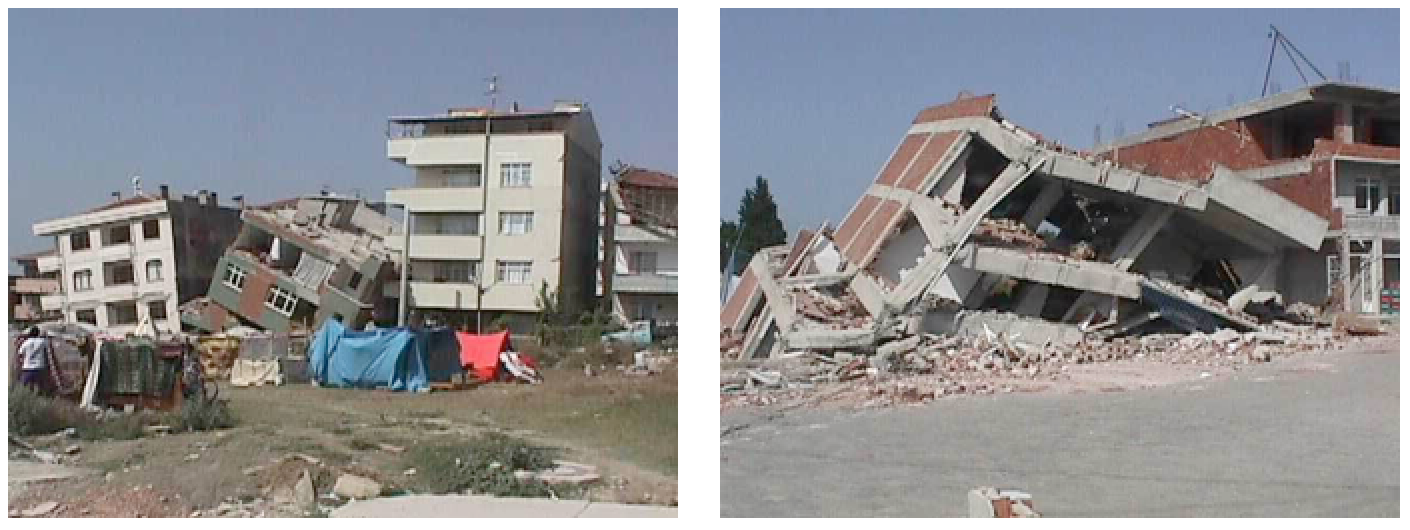
Building damage is also greatest in areas of soft sediments, and multi-story buildings tend to be more seriously damaged than smaller ones. Buildings can be designed to withstand most earthquakes, and this practice is increasingly applied in earthquake-prone regions. Turkey is one such region, and even though Turkey had a relatively strong building code in the 1990s, adherence to the code was poor, as builders did whatever they could to save costs, including using inappropriate materials in concrete and reducing the amount of steel reinforcing (Figure 5.4.4). The result was that there were over 17,000 deaths in the 1999 M7.6 Izmit earthquake. After two devastating earthquakes that year, Turkish authorities strengthened the building code further, but the new code has been applied only in a few regions, and enforcement of the code is still weak, as revealed by the amount of damage from a M7.1 earthquake in eastern Turkey in 2011. (5)
Fires
Fires are commonly associated with earthquakes because fuel pipelines rupture and electrical lines are damaged when the ground shakes. Most of the damage in the great 1906 San Francisco earthquake was caused by massive fires in the downtown area of the city. Some 25,000 buildings were destroyed by those fires, which were fuelled by broken gas pipes. Fighting the fires was difficult because water mains had also ruptured. The risk of fires can be reduced through P-wave early warning systems if utility operators can reduce pipeline pressure and close electrical circuits. (5)


Landslides
Landslides by themselves are a major geologic hazard, since they are widespread. Earthquakes are important triggers for failures on slopes that are already weak. An example is the Las Colinas slide in the city of Santa Tecla, El Salvador, which was triggered by a M7.6 offshore earthquake in January 2001 (Fig. 5.4.6). This is just one of many hundreds of slope failures that resulted from that earthquake. Over 500 people died in the area affected by this slide. (5)

Liquefaction
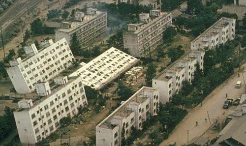
Ground shaking during an earthquake can be enough to weaken rock and unconsolidated materials to the point of failure, but in many cases the shaking also contributes to a process known as liquefaction in which an otherwise solid body of sediment is transformed into a liquid mass that can flow. When water-saturated sediments are shaken, the grains become rearranged to the point where they are no longer supporting one another. Instead, the water between the grains is holding them apart and the material can flow. Liquefaction can lead to the collapse of buildings and other structures that might be otherwise undamaged. A good example is the collapse of apartment buildings during the 1964 Niigata earthquake (M7.6) in Japan (Fig. 5.4.7). Liquefaction can also contribute to slope failures and to fountains of sandy mud (sand volcanoes) in areas where there is loose saturated sand beneath a layer of more cohesive clay. (5)
Tsunami
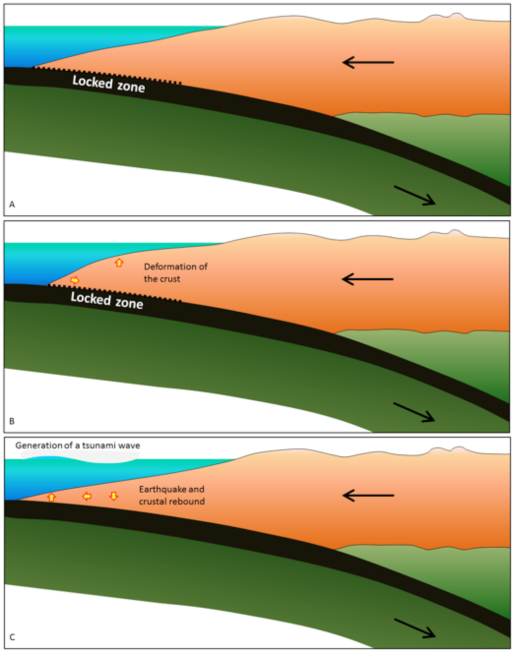
Earthquakes that take place beneath the ocean have the potential to generate tsunami. The most likely situation for a significant tsunami is a large (M7 or greater) subduction-related earthquake, because the seafloor is dramatically moved. As shown in Figure 5.4.8, during the time between earthquakes the overriding plate becomes distorted by elastic deformation; it is squeezed laterally and pushed up. When an earthquake happens, the plate rebounds and there is both uplift and subsidence on the sea floor, in some cases by as much as several meters vertically over an area of thousands of square kilometers. This vertical motion is transmitted through the water column where it generates a series of waves that then spread across the ocean. Subduction earthquakes with magnitude less than 7 do not typically generate significant tsunami because the amount of vertical displacement of the sea floor is minimal. Sea-floor transform earthquakes, even large ones (M7 to M8), don’t typically generate tsunami either, because the motion is mostly side to side, not vertical. (5) While tsunami can affect any coastal region, they are much more likely in areas with subduction zones, like the Pacific Ring of Fire.
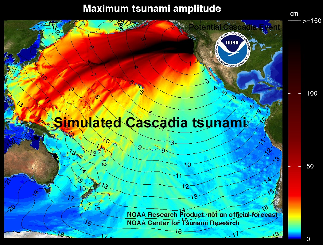
Tsunami waves travel at velocities of several hundred kilometers per hour and easily make it to the far side of an ocean in about the same time as a passenger jet. The simulated one shown in Figure 5.4.9 is similar to that created by the 1700 Cascadia earthquake off the coast of British Columbia, Washington, and Oregon, which was recorded in Japan nine hours later. (5)
Risk
Earthquakes cause a lot of damage. This damage can include structural damage to buildings, fires, damage to bridges, highways, pipelines and electrical transmission lines, initiation of slope failures, liquefaction, and tsunami. The types of impacts depend to a large degree on where the earthquake is located: whether it is predominantly urban or rural, densely or sparsely populated, highly developed or underdeveloped, and, of course, on the ability of the infrastructure to withstand shaking.
As we have discussed, a geologic hazard is the potential for loss or damage. However, the risk can vary related to population and infrastructure, as well as other factors, of the place where the hazard occurs. We will focus on the geologic hazards but it is important to remember the context in which the hazard occurs.
A process by which water-saturated sediment temporarily loses strength and acts as a fluid
A region extending along the islands and coastlines bordering the Pacific ocean that is affected by convergent and transform plate boundaries. These boundaries cause a higher incidence of earthquakes and volcanoes.
an extreme natural event that is a threat to life and property
