
6.7 Attributions and References
Creative Commons Attributions for Chapter Text
(1) Natural Disasters and Human Impacts by R. Adam Dastrup, MA, GISP is licensed under CC BY-NC-SA 4.0
(2) United States Geological Survey (USGS) is licensed under Public Domain.
(3) Physical Geology – 2nd Edition by Steven Earle is licensed under CC BY 4.0.
(4) NOAA National Centers for Environmental Information (NCEI) U.S. Billion-Dollar Weather and Climate Disasters (2021). https://www.ncdc.noaa.gov/billions/, DOI: 10.25921/stkw-7w73
Media Assets
Fig. 6.1 NASA (n.d.). “Flooding in Australia” April 5, 2021 from https://www.flickr.com/photos/24662369@N07/5348891363
6.1
Video 6.1.1. Kleinberg, C., Foreman, A. (2013) How polarity makes water behave strangely. TED-ED [Online Video]. Retrieved April 27, 2022 https://youtu.be/ASLUY2U1M-8
Fig. 6.1.1 Perlman, H., Cook, J., Nieman, A., Shiklamonov (n.d.) The World’s Water.
- An image showing the relative amounts of Earth’s water in comparison to the size of the Earth.
Fig. 6.1.2 USGS (1993) Where is Earth’s Water? Retrieved June 2, 2021 from https://water.usgs.gov/edu/gallery/watercyclekids/earth-water-distribution.html
- An estimation of where the Earth’s water exists on, within, and around the Earth.
Video 6.1.2 Met Office – Weather. (n.d.). How does the water cycle work? [Online Video]. Retrieved February 23, 2019, from https://www.youtube.com/watch?v=SvA11IuweNk
- An animation to explain the water cycle.
Video 6.1.3. NASA Goddard. (n.d.). NASA | Earth’s Water Cycle. [Online Video]. Retrieved February 23, 2019, from https://www.youtube.com/watch?v=oaDkph9yQBs
- An animation using Earth science data from NASA satellites to show the continuous movement of water on Earth.
Figure 6.1.3 Arizona State University School of Geographical Sciences and Urban Planning (n.d.) Average Annual Precipitation 1981-2010. Retrieved March 27, 2021 from http://www.public.asu.edu/~aunjs/PrecipMaps.htm
- Map showing average annual precipitation in Arizona from 1981-2010.
6.2
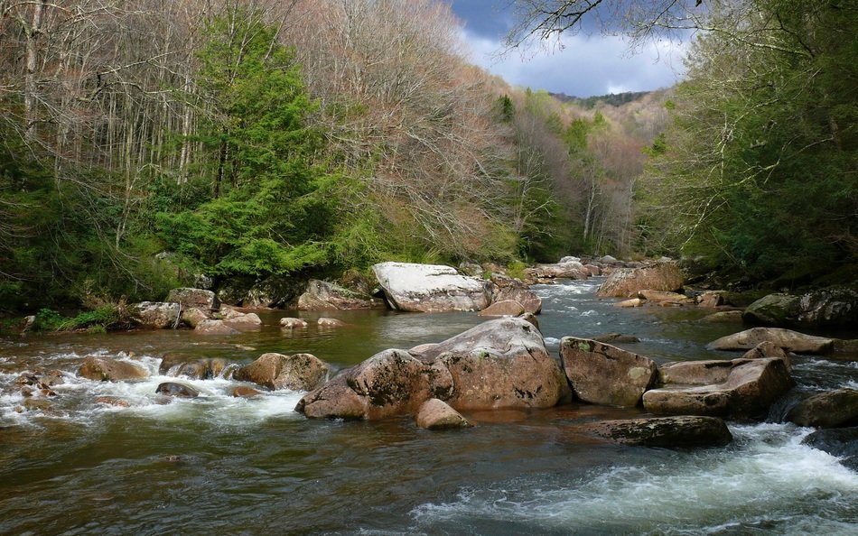
Fig. 6.2.1 Wikimedia Commons (n.d.) Stream River Landscape. Retrieved March 27, 2021 from https://pixy.org/src/22/thumbs350/226560.jpg
- An image showing stream landscape.
Fig. 6.2.2 Ferrie, Tony (2007) River Source by Retrieved March 27, 2021 from https://upload.wikimedia.org/wikipedia/commons/c/c3/River_source_-_geograph.org.uk_-_380822.jpg
- An image showing the headwaters of a river in Sgurr na Ciche, Scotland.
Fig. 6.2.3 NASA (2011) Flooding at the Junction of the Mississippi and Ohio Rivers. Retrieved March 27, 2021 from https://earthobservatory.nasa.gov/images/50475/flooding-at-the-junction-of-the-mississippi-and-ohio-rivers
- An image showing the muddy waters of the Mississippi River intersecting the cleaner waters of the Ohio River after the flooding event in 1993.
Fig. 6.2.4 NASA (1990) Mouths of Amazon Geocover. Retrieved March 27, 2021 from https://commons.wikimedia.org/wiki/File:Mouths_of_amazon_geocover_1990.png
- An satellite image showing the mouth of the Amazon River.
Fig. 6.2.5 Pfly (2010) North America-Water Divides. Retrieved March 27, 2021 from https://commons.wikimedia.org/wiki/File:NorthAmerica-WaterDivides.png
- Map showing major continental divides of North America.
Fig. 6.2.6 USGS (2019) Diagram of Channel Cross Section with Subsections. Retrieved March 27, 2021 from https://www.usgs.gov/media/images/diagram-channel-cross-section-subsections
- A diagram showing a cross section of a stream and the method used to determine area and discharge of a stream.
Fig. 6.2.7 USGS (2010). Colorado Basin Focus Area Study Map. Retrieved March 27, 2021 from https://www.usgs.gov/media/images/colorado-basin-focus-area-study-map
- A map showing all the area covered in the Colorado River Drainage Basin that was the study area of the USGS.
6.3
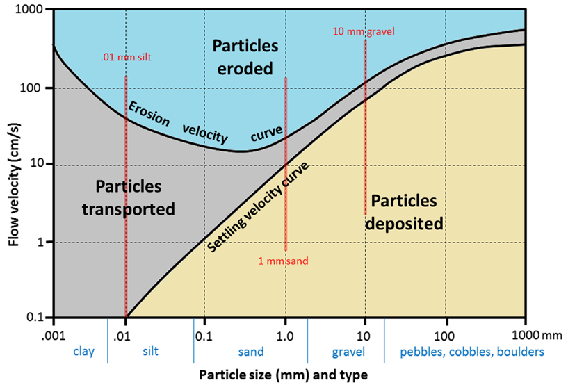
Fig. 6.3.1 Earle, S. (n.d.) Hjulström-Sundborg diagram. Retrieved March 27, 2021 from https://openeducationalberta.ca/practicalgeology/wp-content/uploads/sites/66/2020/06/hulstrom-2.png
- A diagram showing the relationships between particle size and tendency to be eroded, transported, or deposited at different current velocities.
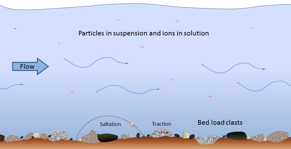
Fig. 6.3.2 Earle, S (n.d.) Modes of transportation of sediments and dissolved ions. Retrieved March 27, 2021 from https://opentextbc.ca/physicalgeology2ed/wp-content/uploads/sites/298/2019/08/transportation-of-sediments.png
- A diagram showing movement of sediments within a stream.
Fig. 6.3.3 Wilson, M (2019) Grand Canyon Overlook
- An image from the South Rim of the Grand Canyon looking northwest over Plateau Point and the Inner Gorge.
6.4
Video 6.4.1. National Park Service (2017) Anatomy of a Flood. [Online Video]. Retrieved March 27, 2021 from https://youtu.be/dd0-ZsDAgNw
- Video showing causes and effects of flooding around Mt. Ranier
Video 6.4.2. USGS (2011) Post-fire Flash Flood in Coronado National Memorial, Arizona (2011). [Online Video]. Retrieved March 27, 2021 from https://youtu.be/aAR6FWR35BU
- Video of a flash flood quickly filling a dry river bed in Arizona.
Fig. 6.4.1 NOAA (n.d.) El Nino weather pattern. Retrieved March 27, 2021 from https://oceanservice.noaa.gov/facts/ninonina.html#:~:text=El%20Nino%20means%20Little%20Boy,can%20affect%20our%20weather%20significantly.
- El Nino causes the Pacific jet stream to move south and spread further east. During winter, this leads to wetter conditions than usual in the Southern U.S. and warmer and drier conditions in the North.
Fig. 6.4.2 Earle, S. (n.d.) Natural levees. Retrieved June 2, 2021.
6.5
Video 6.5.1. Practical Engineering (2021) How Do Flood Control Structures Work? [Online Video]. Retrieved March 27, 2021 from https://www.youtube.com/watch?v=5mCJh5SJEis
- A video describing flood control structures.
Fig. 6.5.1 Roan, T. (n.d.) Glen Canyon Bridge & Dam, Page, Arizona. Retrieved March 27, 2021 at https://live.staticflickr.com/2107/2101168562_f7e419505d_b.jpg
- Image of the Glen Canyon Dam, Arizona.
Fig. 6.5.2 Army Corp of Engineers (2011) Kansas Flood. Flickr, Public Domain.
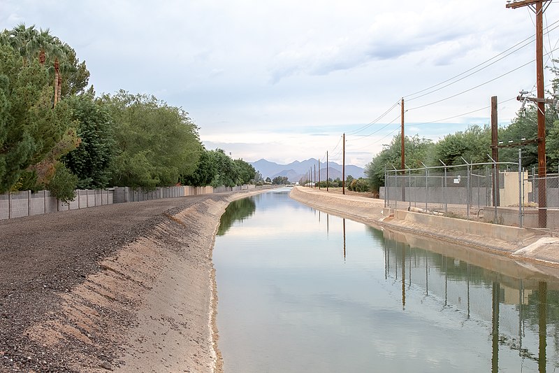
Fig. 6.5.3 World Bank (2019, May 2) Canals, flood controls stations and water retention basins. Retrieved June 2, 2021 from https://www.flickr.com/photos/worldbank/46970648244/in/photostream/
- Image of a canal
Fig. 6.5.4 Wikimedia Commons (2019) Hohokam Canal. Retrieved June 2, 2021 from https://upload.wikimedia.org/wikipedia/commons/thumb/e/eb/Hohokam_Canal.jpg/800px-Hohokam_Canal.jpg
- Image of a modern day canal that follows the path of the Hohokam canal system
Fig. 6.5.5 FEMA (2008) Driver pushing a car through flood waters. Retrieved June 2, 2021 from https://en.wikipedia.org/wiki/Stupid_Motorist_Law#/media/File:FEMA_-_37218_-_Resident_pushing_a_car_through_flood_waters_in_Texas.jpg
- Image of a man pushing a car through flood waters in Brownsville, TX, after Hurricane Dolly in 2008.
Fig. 6.5.6 NOAA National Centers for Environmental Information (NCEI) U.S. Billion-Dollar Weather and Climate Disasters (2021). https://www.ncdc.noaa.gov/billions/, DOI: 10.25921/stkw-7w73
- Infographic showing the relative costs of natural disasters in the United States from 1980-2020.
6.6
Fig. 6.6.1. NASA ( 2010). Rio Negro Floodplain, Patagonia, Argentina. Retrieved April 5, 2021 from https://www.flickr.com/photos/28634332@N05/4358585360
Instructor Resources
Clark, H (2005) Lake Powell Multibeam Mapping 2005. Retrieved March 27, 2021 from http://www.omg.unb.ca/Projects/LakePowell/
FEMA, (n.d.) Benefits of Natural Floodplains. Retrieved April 5, 2021 from https://www.fema.gov/floodplain-management/wildlife-conservation/benefits-natural
Dictionary of Water Terms. (n.d.). Retrieved May 11, 2020, from https://www.usgs.gov/special-topic/water-science-school/science/dictionary-water-terms?qt-science_center_objects=0#qt-science_center_objects.
US Bureau of Reclamation (2016) Colorado River Basin Fact Sheet. Retrieved March 27, 2021 from https://www.usbr.gov/climate/secure/docs/2016secure/factsheet/ColoradoRiverBasinFactSheet.pdf.
USGS (n.d.) River Sediment Dynamics. Retrieved March 27, 2021 from https://www.usgs.gov/centers/sbsc/science/fluvial-river-sediment-dynamics?qt-science_center_objects=0#qt-science_center_objects.
Instructor Resources
