
8.2 Ocean Currents
Throughout the ocean there is an interconnected circulation system powered by wind, tides, the force of Earth’s rotation, the Sun, and water density differences. The shape of ocean basins, and adjacent land masses, influence the circulation path. The “global ocean conveyor belt” moves water throughout all the ocean basins, transporting energy (heat), matter, and organisms around the ocean. Changes in ocean circulation have a large impact on the climate and cause changes in ecosystems. (0)
Video 8.2.1. What causes ocean currents? Watch this animation by TED Talk (4:33)
Surface currents
Ocean water moves in predictable ways along the ocean surface. Surface currents can flow for thousands of kilometers and can reach depths of hundreds of meters. These surface currents do not depend on the weather. (2)
Global wind currents
Winds on Earth are either global or local. Global winds blow in the same directions all the time and are related to the unequal heating of Earth by the Sun, that is that more solar radiation strikes the equator than the polar regions, and the rotation of the Earth. Water in the surface currents is pushed in the direction of the significant wind belts:
- Trade winds are consistent winds that flow east to west between the equator and 30 degrees North and 30 degrees South latitude.
- Westerlies are the prevailing winds that blow from the west in the middle latitudes.
- Polar easterlies are winds that flow from the east between 50 degrees and 60 degrees north and south latitude, as well as the north and south poles.
Rotation of the Earth
Earth’s rotation steers winds and surface ocean currents. In simple terms, the Coriolis Effect causes non-anchored objects (like planes or currents) to appear to move to the right in the Northern Hemisphere and to the left in the Southern Hemisphere. The objects themselves are moving straight, but the Earth is rotating beneath them, so they seem to bend. (2)
Video 8.2.2. Visualize the surface ocean currents in our globe. This animation is a high-resolution model developed by NASA (3:02).
As wind or ocean currents move, the Earth spins underneath it. As a result, an object moving north or south along the Earth will appear to move in a curve, instead of in a straight line. Wind or water that travels toward the poles from the equator is deflected to the east, while wind or water that travels toward the equator from the poles gets bent to the west. The Coriolis effect bends the direction of surface currents to the right in the Northern Hemisphere and left in the Southern Hemisphere. (2)
An example might make the Coriolis effect easier to visualize. If an airplane flies five hundred miles due north, it will not arrive at the city that was due north of it when it began its journey. Over the time it takes for the airplane to fly five hundred miles, that city moved, along with the Earth it sits on. Therefore, the airplane will arrive at a city to the west of the original city (in the Northern Hemisphere) unless the pilot has compensated for the change. So, to reach his intended destination, the pilot must also veer right while flying north.
Deep currents
Thermohaline circulation drives deep ocean circulation. Thermo means heat, and haline refers to salinity. Differences in temperature and salinity change the density of seawater. The thermohaline circulation results from density differences in water masses because of their different temperature and salinity. (5)
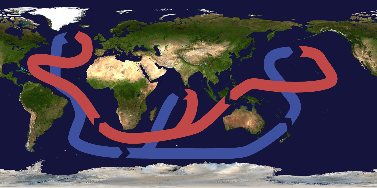
Lower temperature and higher salinity yield dense water. When a volume of water is cooled, the molecules move more slowly, and the same number of molecules takes up less space, thus, the water is denser. If salt is added to a volume of water, the number of molecules in that volume increases. This also leads to increased density. Changes in temperature and salinity of seawater take place at the surface. Water becomes dense near the poles. Cold polar air cools the water and lowers its temperature, increasing its salinity. Freshwater freezes out of seawater to become sea ice, which also increases the salinity of the remaining water. This frigid, very saline water is very dense and sinks, a process called downwelling. (1)
Two things then happen. The dense water pushes deeper water out of its way, and that water moves along the bottom of the ocean. This deep-water mixes with less dense water as it flows. Surface currents move water into the space vacated at the surface where the dense water sank. Water also sinks into the deep ocean off Antarctica. Since unlimited amounts of water cannot sink to the ocean’s bottom, water must rise from the deep ocean to the surface somewhere. This process is called upwelling. (1)
Video 8.2.3. This animation first depicts thermohaline surface flows and the sinking of water in the dense ocean near Iceland and Greenland. Then it reveals the global thermohaline circulation (1:23)
Upwelling occurs along the coast when the wind blows water strongly away from the shore. This leaves a void that is filled with deep water that rises to the surface. Upwelling is significant where it occurs. During its time on the bottom, the cold deep water has collected nutrients that have fallen through the water column. Upwelling brings those nutrients to the surface. That nutrient supports the growth of plankton and forms the base of a vibrant ecosystem. California, South America, South Africa, and the Arabian Sea all benefit from offshore upwelling. Upwelling also takes place along the equator between the North and South Equatorial Currents. Winds blow the surface water north and south of the equator, so deep water undergoes upwelling. The nutrients rise to the surface and support a great deal of life in the equatorial oceans. (2)
consistent winds that flow east to west between the equator and 30 degrees North and 30 degrees South
are the prevailing winds that blow from the west in the middle latitudes.
winds that flow from the east between 50 degrees and 60 degrees north and south latitude, as well as the north and south poles
circulation due to density differences in water masses because of their different temperature and salinity
