
11.4 Weather Hazards
Tornadoes
One of the most violent and destructive forces of weather are tornadoes. The National Weather Service states that “a tornado is a violently rotating (usually counter-clockwise in the northern hemisphere) column of air descending from a thunderstorm and in contact with the ground.”
It is pretty much an extension of a supercell’s mesocyclone. They range in size from 300 feet to over two miles wide, last minutes to hours, travel a few miles to over 250 miles, at speeds of 30-65 mph. About 75 percent of all the tornadoes in the world occur in the United States; the United States has more tornadoes than the rest of the world combined.
What makes tornadoes so destructive are the wind speeds within them. Atmospheric pressure within a tornado can be 10 percent lower than the tornado’s air, causing air to flow into the tornado from all directions. As the air flows into a tornado, the moisture begins to cool and condense into a cloud, allowing it to be seen. Debris picked up by the tornado will also cause it to darken.
Tornado Formation
The anatomy and development of tornadoes are not fully understood, but they form from cold fronts, severe thunderstorms, squall lines, supercells, and hurricanes. Geography also plays a crucial role in determining where tornadoes can and can not form. The majority of thunderstorms in the United States form in the Midwest, called Tornado Alley. This region is where cP air masses from Canada collide with mT air from the Gulf of Mexico. This wind shear creates unstable atmospheric conditions and a rotating corkscrew column of air.

As the ground heats up through the day, updrafts pick up the rotating air into a portion of the thunderstorm to develop what is called a rotating mesocyclone. The updrafts stretch and tighten the now vertical column of air, causing it to rotate faster, much like an ice skater tightens to spin faster. As the rotating updrafts rise, a rotating wall cloud begins to form from the base of a mesocyclone. Sometimes a funnel cloud may begin to descend from the mesocyclone and may even be called a tornado if it reaches the ground.

Since 1990, the United States has averaged 1,200 tornadoes reported every year. However, the exact number per year can vary. Because the contrast between cold polar air and warm subtropical air is most significant in the spring and fall, most tornadoes in the United States develop during those seasons with April through June being the greatest.
Tornado Destruction
The original way tornadoes were classified was based on a scale system developed by Dr. Fujita, which became called the Fujita Intensity Scale or simply the F-scale. The Storm Prediction Center states that the Fujita Intensity Scale’s goal was to “categorize each tornado by its intensity and its area and estimate a wind speed associated with the damage caused by the tornado.” The scale ranged from weak F0s to rare and obliterating F5s.
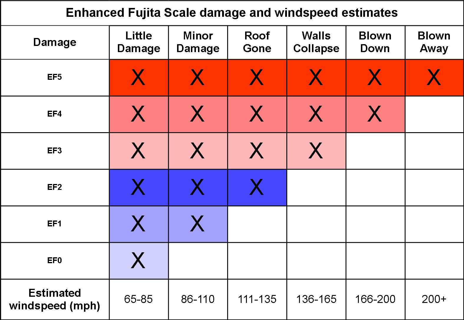
In February 2007, a new classification system began called the Enhanced Fujita Scale, or the EF-scale. The scale still ranges from 0-5 and is still an estimate of the tornado’s wind speeds. However, the new scale is based on the amount of damage to different structures instead of actual wind speed. The stronger focus on the actual damage caused is because some structures and objects are built stronger than others. Examples of various strengths could include wood-framed homes, brick homes, malls, churches, and steel buildings.
The majority of deaths caused by a tornado are not caused by wind, but by the flying debris. Sometimes a tornado will pass through a neighborhood and destroy some houses while leaving others with little damage. Scientists have discovered that some massive, intense tornadoes might contain several smaller tornadoes within them called suction vortices that makeup what is called multiple vortex tornadoes. (Dastrup, 2014)
Tornado Forecasting
A lot of time, money, and research has gone into understanding tornadoes to provide better warnings to the public. When the atmospheric conditions are right, the Storm Prediction Center (SPC), which is part of the National Weather Service, analyzes severe weather and posts its forecasts to alert the public. If the conditions are right for a tornado to form, the SPC will send out a tornado watch alerting the public of the possibility of a tornado in a given area within a specific time. When a tornado has been cited, the National Weather Service will send a tornado warning out. A tornado warning warns of a “high probability of imminent danger” to a specific location.
Doppler radar has become vital in determining the location and intensity of precipitation and locating where mesocyclones and tornadoes may be forming. Doppler radar can do this by monitoring the wind’s flow toward or away from the tower, called the Doppler effect. Click here to view an image of an EF5 tornado approaches the Doppler. Notice a hook echo form in the red and begin rotating counter-clockwise, as most low-pressure systems do in the Northern Hemisphere. Weather satellites have also become instrumental in weather forecasting and monitoring. (Dastrup, 2014)

Lightning
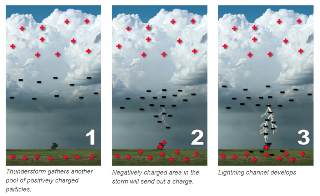
Lighting is how the atmosphere balances out the buildup of opposite electrical charges within a cumulonimbus. The buildup occurs when charged atmospheric particles become segregated between a cloud and the ground, between clouds, or from a cloud and surrounding atmosphere. Scientists do not fully understand the reason for charged particle separation. However, some believe that ice crystals called graupel and supercooled raindrops interact with each other through collision, creating positive and negative charges that get separated within the cloud by updrafts and downdrafts. Others believe that ice pellet formation within the cloud charges the particles. As an ice pellet forms, the outer shell freezes first and becomes positively charged, and the liquid inner core is negatively charged. As the interior begins to freeze and expand, it breaks apart the positively charged outer layers. These positively charged fragments are taken into the cloud’s upper regions, giving the top of the cloud a positive charge. The denser liquid water has a negative charge and is at the base of the cloud.
Once charged particles are separated, an electrical attraction exists between the negative and positive charges. The air between the oppositely charged particles tries to keep them separated. However, when the air can not keep the two opposite charges separated any longer, the negative charges move towards the positive charge in a zigzag manner called a stepped leader. As the stepped leader approaches the ground, the surface’s positive charges will rise toward the steeped leader. It may rise through trees, buildings, or humans. When the steeped leader and the rising positively charged particles connect, the negatively charged particles flow from the cloud to the ground. At the same time, an electrical discharge called a return stroke, flows from the ground toward the cloud along the same path as the stepped leader. The return stroke is the part we see as lightning. When lightning flickers, it is because this process is repeating itself along the same path. Eighty percent of all lightning strikes occur cloud-to-cloud, but this process mentioned above can occur with cloud-to-ground, cloud-to-cloud, and cloud-to-air.
Lightning is only a few centimeters thick but travels at 60,000 mph with a temperature of 54,000 degrees F (five times hotter than the surface of the sun). Lightning causes the surrounding air to become superheated, causing the air to expand violently, creating a shockwave called thunder. To estimate how far you are from lightning, count the number of seconds between the flash of lightning and when you hear the thunder reach you, then divide by five. However, if the lightning strike is more than 12 miles away, thunder will not be heard.
In the summertime, convection or orographic uplift can create dry thunderstorms. Dry thunderstorms typically mean storms that have lightning, but little to no precipitation falling. Often this occurs when thunderstorms develop in dry atmospheric conditions. Because the air is so dry, rising eddies of moisture must reach great heights before being able to condense. This creates thunderstorms with very high cloud-bases. Any precipitation that does fall in these dry atmospheric conditions is likely to evaporate before reaching the ground. Thus these thunderstorms can create lighting, which can cause ignite wildfires, and the evaporating precipitation can produce strong, dry winds that can “push” the fires around.
Hail
Hail is precipitation in the form of ice pellets that only forms in cumulonimbus clouds where the lower region of the cloud contains liquid water and the upper region containing ice freezing. When an ice pellet falls within the cumulonimbus cloud, it enters the warm, liquid region and picks up moisture. Then the updrafts through the ice pellet back up above the freezing point hardening the newly gathered water. The ice pellet will fall again to collect liquid water and thrown back up to refreeze. This process will continue until the hailstone’s weight becomes too heavy for the updrafts to hold it up. Once the hail becomes too heavy, the hail will precipitate on the downdraft side of the cumulonimbus. (Weather Processes and Systems | Earth Science, n.d.)
Flash Floods
The number one weather-related cause of death in the United States are flash floods. The National Weather Service states that “flash floods are short-term events, occurring within 6 hours of the causative event (heavy rain, dam break, levee failure, rapid, snowmelt and ice jams) and often within 2 hours of the start of high-intensity rainfall. A flash flood is characterized by a rapid stream rise with depths of water that can reach well above the creek banks. Flash flood damage and most fatalities tend to occur in areas immediately adjacent to a stream or arroyo. Additionally, heavy rain falling on steep terrain can weaken the soil and cause mudslides, damaging homes, roads, and property.” Urbanized areas are susceptible to flash floods because soil and vegetation are removed and replaced by concrete, roads, and buildings. When intense precipitation occurs, the water has nowhere to go. Learn more about flash floods from the National Weather Service. (Ch 9 Living with Disasters, n.d.)
Microbursts
One weather-related hazard is microbursts, which are frequently caused by outflow boundaries. Sometimes the moisture within downdrafts falling from the thunderstorm evaporates as it enters dryer air below the cloud. As the moisture evaporates, the air cools because of latent heat, causing the air to become denser. This, in turn, causes the air to fall faster. As this denser air hits the ground, it spreads out laterally, producing cold winds reaching 100 miles per hour. Microbursts can uproot trees, damage property, and are very dangerous for airplanes taking off or landing.

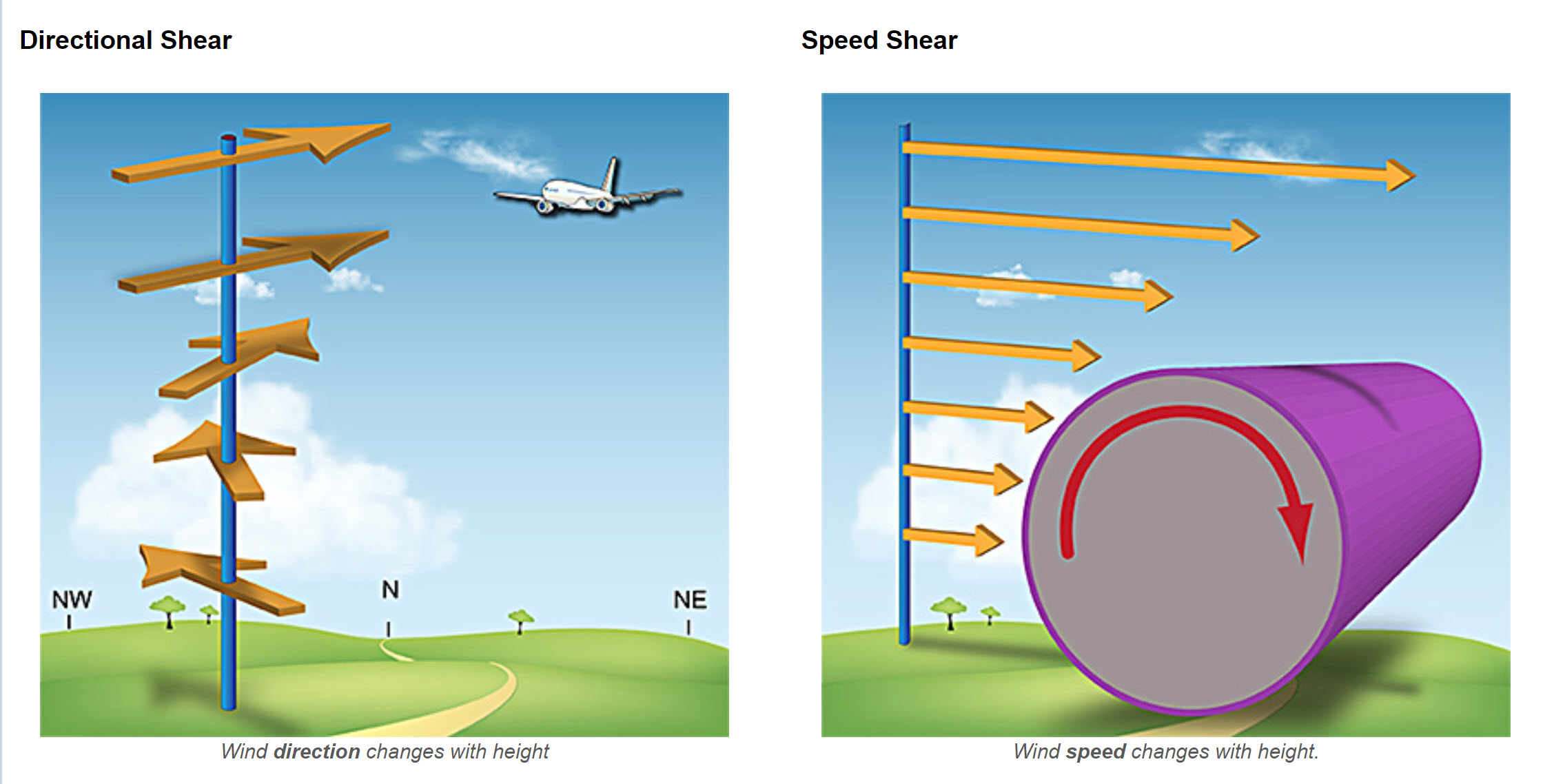
Winds, crosswinds, and microbursts are all significant concerns for aviation pilots, especially when are traveling over 200 mph and are only 100-500 feet from the ground below. However, many of these near-crashes have been captured on video from all around the world because of technology. Below is a video on some of the best landings ever done by pilots fighting crosswinds and microbursts.
