
4.8 Attributions and References
Creative Commons Resources for Chapter Text
The following resources have been used for research, starting points, and inspiration for this chapter and are available to all under Fair Use or Creative Commons Licensing. Unless otherwise noted in Attributed References or Media Assets, materials have been significantly reworked by this text’s authors.
Dastrup, R. Adam. (2020, Jun 1). Physical Geography and Natural Disasters. https://slcc.pressbooks.pub/physicalgeography/CC BY-NC-SA.
An Introduction to Geology by Chris Johnson, Matthew D. Affolter, Paul Inkenbrandt, Cam Mosher is licensed under CC BY-NC-SA 4.0
Geology by Lumen Learning is licensed under CC BY-NC-SA 4.0
Earth Science by Lumen Learning is licensed under CC BY-NC-SA 4.0
Natural Disasters and Human Impacts by R. Adam Dastrup, MA, GISP is licensed under CC BY-NC-SA 4.0
Physical Geology – 2nd Edition by Steven Earle is licensed under CC BY 4.0.
Introduction to Oceanography by Paul Webb is licensed under CC BY 4.0.
United States Geological Survey (USGS) is licensed under Public Domain.
Google Earth is available as Fair Use under Section 107 of the United States Copyright Act.
Chapter Text Attributions
[1] Dastrup, R. Adam. (2020, Jun 1). Tectonic Forces. Physical Geography and Natural Disasters. https://slcc.pressbooks.pub/physicalgeography/chapter/4-1/
[2] House Mountain, Verde Valley, Arizona. (2008, Nov). Arizona Geological Survey. https://azgs.arizona.edu/photo/house-mountain-verde-valley-arizona
[3] An Introduction to Geology by Chris Johnson, Matthew D. Affolter, Paul Inkenbrandt, Cam Mosher is licensed under CC BY-NC-SA 4.0
[4] Ashfall is the most widespread and frequent volcanic hazard. (n.d.). USGS Volcano Hazards Program. https://www.usgs.gov/natural-hazards/volcano-hazards/ashfall-most-widespread-and-frequent-volcanic-hazard
[5] Volcanoes Can Affect Climate. (n.d.). USGS Volcano Hazards Program. https://www.usgs.gov/natural-hazards/volcano-hazards/volcanoes-can-affect-climate
[6] Comprehensive monitoring provides timely warnings of volcano reawakening. (n.d.). USGS Volcano Hazards Program. https://www.usgs.gov/natural-hazards/volcano-hazards/monitoring
[7] Monitoring Volcano Seismicity Provides Insight to Volcanic Structure. (n.d.). USGS Volcano Hazards Program. https://www.usgs.gov/natural-hazards/volcano-hazards/monitoring-volcano-seismicity-provides-insight-volcanic-structure
[8] Movement on the Surface Provides Information About the Subsurface. (n.d.). USGS Volcano Hazards Program. https://www.usgs.gov/natural-hazards/volcano-hazards/movement-surface-provides-information-about-subsurface
[9] Volcanic gases and water include chemical signatures of magma. (n.d.). USGS Volcano Hazards Program. https://www.usgs.gov/natural-hazards/volcano-hazards/volcanic-gases-and-water
[10] Sunset Crater. (n.d.). Arizona Geological Survey. https://azgs.arizona.edu/azgs-photo-tags/sunset-crater
[11] Learn about volcano hazard zones where you live or visit. (n.d.). USGS Volcano Hazards Program. https://www.usgs.gov/natural-hazards/volcano-hazards/learn-about-volcano-hazard-zones-where-you-live-or-visit
[12] Be informed. Make a plan. Build a kit. (n.d.). USGS Volcano Hazards Program. https://www.usgs.gov/natural-hazards/volcano-hazards/be-informed-make-a-plan-build-a-kit
[13] During volcanic unrest, follow recommendations from officials. (n.d.). USGS Volcano Hazards Program. https://www.usgs.gov/natural-hazards/volcano-hazards/during-volcanic-unrest-follow-recommendations-officials
[14] Impacts from volcanic events can last for months to years after the eruption ends. (n.d.). USGS Volcano Hazards Program. https://www.usgs.gov/natural-hazards/volcano-hazards/impacts-volcanic-events-can-last-months-years-after-eruption-ends
[15] Old Faithful Geyser Frequently Asked Questions. (2018, Jul 6). National Park Service. https://www.nps.gov/yell/learn/nature/oldfaithfulgeyserfaq.htm
[16] Olson, C. and Whitley, K. (2011). Castle Hot Springs. Arizona Heritage Waters. http://www.azheritagewaters.nau.edu/loc_Castle_Hot.html
[17] Energy. (n.d.). Government of Iceland. https://www.government.is/topics/business-and-industry/energy/
Media Assets
All images, videos, animations, and H5P activities within this chapter are licensed under Creative Commons, or in rare circumstances, Fair Use.
Fig. 4.1. Bkilli1. (2013, Oct 9). “Geothermal Gradient.” [Online Image]. Wikimedia Commons. https://commons.wikimedia.org/wiki/File:Temperature_schematic_of_inner_Earth.jpg CC BY-SA 3.0
- The Geothermal Gradient within Earth.
4.1
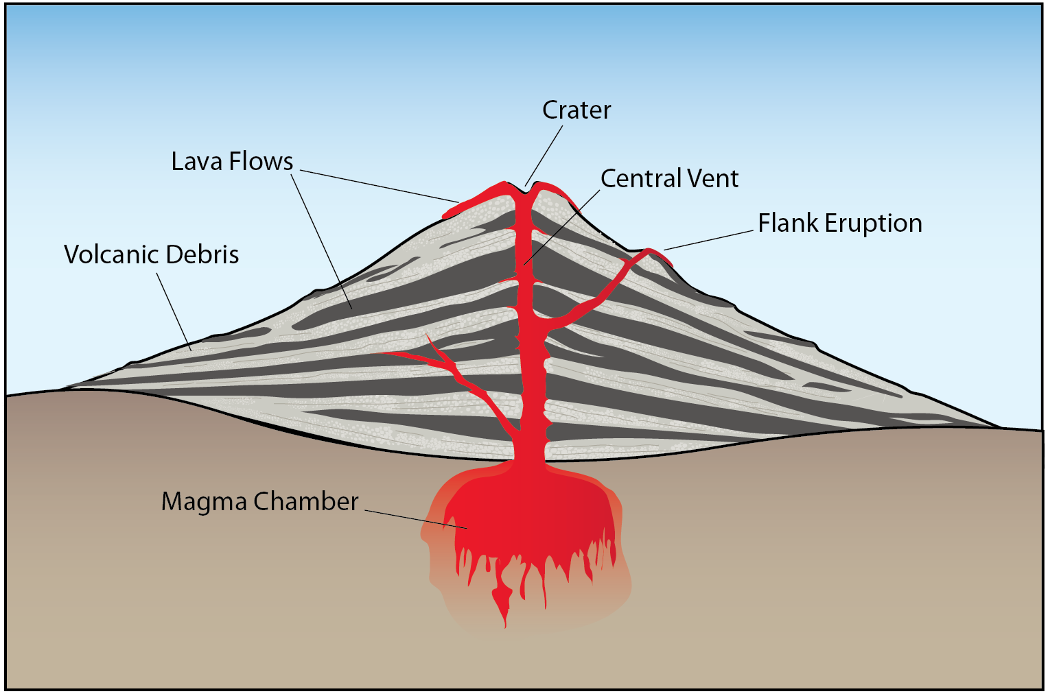
Fig. 4.1.1. Karla Panchuk. (2017). “stratovolcano.” [Online Image]. PHYSICAL GEOLOGY, FIRST UNIVERSITY OF SASKATCHEWAN EDITION. https://openpress.usask.ca/app/uploads/sites/29/2017/08/stratovolcano.png CC BY.
- Different parts of a volcano.
Figure 4.1.2. kuknmi. (2015, Sep 7). “Lava Fountain.” [Online Image]. Flickr. https://www.flickr.com/photos/31176607@N05/28456514846 CC BY.
- Eruption of a lava fountain.
Fig. 4.1.3. Woudloper. (2010, May). “Magmatism and Volcanism.” [Online Image]. Wikimedia Commons. https://commons.wikimedia.org/wiki/File:Magmatism_and_volcanism_EN.svg CC BY-SA
- Diagram of magma forming at depth and rising toward a volcano and erupting as lava.
Fig. 4.1.4. Steven Earle. (n.d.). “Figure 10.4.3.” [Online Image]. Physical Geology – 2nd Edition. https://opentextbc.ca/physicalgeology2ed/chapter/10-4-plate-plate-motions-and-plate-boundary-processes/ CC BY
- Decompression melting of magma at a divergent boundary.
Fig. 4.1.4. KDS4444. (2016, May 26). “Subduction.” [Online Image]. Wikimedia Commons. https://commons.wikimedia.org/wiki/File:Subduction-en.svg CC BY-SA.
- Subduction of a tectonic plate causes flux melting and volcanism.
Video 4.1.1 geolinde. (2019, Mar 12). “Mount St.Helens.” [Online Video]. YouTube. https://www.youtube.com/watch?v=WojOleI9C2s
Video 4.1.2 Earth Rocks! (2019, Jan 23). “Magma Viscosity.” [Online Video]. YouTube. https://www.youtube.com/watch?v=KgwfH3wkfA4
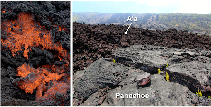
Fig. 4.1.6. Roy Luck and Greg Willis (2009, modified by Karla Panchuk in 2017). “aa.” [Online Image]. Physical Geology, First University of Saskatchewan Edition. https://openpress.usask.ca/app/uploads/sites/29/2017/06/aa.png CC BY-SA.
- Types of mafic lava flows.
4.2
Fig. 4.2.1. Medium69. (2007, Jan 13). “Volcano Structure.” [Online Image]. Wikimedia Commons. https://commons.wikimedia.org/wiki/File:Structure_volcan.png CC BY-SA.
- Cone-shaped volcano structure.
Fig. 4.2.2. USGS. “Cinder_cone_diagram.” [Online Image]. Volcanoes. http://pubs.usgs.gov/gip/volc/types.html Public Domain.
- Schematic of a cinder cone volcano.
Fig. 4.2.3. Sam Beebe. (2009, Jan 23). “Volcán_Chaitén-Sam_Beebe-Ecotrust.” [Online Image]. Wikimedia Commons. https://en.wikipedia.org/wiki/Lava_dome#/media/File:Volcán_Chaitén-Sam_Beebe-Ecotrust.jpg CC BY-SA.
- Lava dome located at Volcán Chaitén, Chile.
Fig. 4.2.4. Top1963. (2009, Dec 29). “Mayon_0052.” [Online Image]. Wikimedia Commons. https://en.wikipedia.org/wiki/Stratovolcano#/media/File:Mayon_0052.jpg CC BY-SA.
- The Mayon Stratovolcano in the Philippines.
Fig. 4.2.5. Sara Carena. (2020, Oct 24). “Mount St Helens.” [Online Model]. Sketchfab. https://sketchfab.com/3d-models/mount-st-helens-usa-4af0f23522c349558d58815d48491ca3 CC BY-NC-SA.
- Mount St. Helens and surrounding landscape in an interactive model.
Fig. 4.2.6. Phillip M. Stewart. (2005, May 16). “Sierra_Grande_volcano.” [Online Image]. Wikimedia Commons. https://commons.wikimedia.org/wiki/File:Sierra_Grande_volcano.jpg CC BY-SA.
- Sierra Grande shield volcano in New Mexico.
Fig. 4.2.7. Jacques Descloitres. (2003, May 23). “Hawaiian Islands.” [Online Image]. NASA’s Earth Observatory. https://earthobservatory.nasa.gov/images/3510/hawaiian-islands Public Domain.
- Hawaiian Islands as examples of shield volcanism.
Fig. 4.2.8. Wayne Ranney. (2008, Nov). “House Mt part2.” [Online Image]. AZGS. https://azgs.arizona.edu/photo/house-mountain-verde-valley-arizona CC BY.
- House Mountain shield volcano near Sedona, AZ.
Fig. 4.2.9. Zainubrazvi. (2006, Jul 18). “Crater Lake.” [Online Image]. Wikimedia Commons. https://en.wikipedia.org/wiki/Caldera#/media/File:Crater_lake_oregon.jpg CC BY-SA.
- Crater Lake Caldera.
Fig. 4.2.10. USGS. (2006, Mar 26). “Mount Mazama eruption timeline.” [Online Image]. Wikimedia Commons. https://en.wikipedia.org/wiki/Caldera#/media/File:Mount_Mazama_eruption_timeline.PNG Public Domain.
- Diagram showing the process of caldera lake formation.
Fig. 4.2.11. Ciaurlec. (2012, Oct 20). “Extent_of_Siberian_traps-it.svg.” [Online Image]. Wikimedia Commons. https://commons.wikimedia.org/wiki/File:Extent_of_Siberian_traps-it.svg CC BY-SA.
Map showing extent of the Siberian flood basalts in Russia.
Fig. 4.2.12. NPS. (2009, Oct 4). “Yellowstone_Caldera.” [Online Image]. Wikimedia Commons. https://commons.wikimedia.org/wiki/File:Yellowstone_Caldera.svg Public Domain.
- Cross-section of Yellowstone hotspot and caldera.
Fig. 4.2.13. USGS. (n.d.). “Yellowstone Relief Map.” [Online Image]. Wikimedia Commons. https://commons.wikimedia.org/wiki/File:Yellowstone_Caldera.svg Public Domain.
- Relief map of area affected by potential Yellowstone eruption.
4.3
Fig. 4.3.1. Jebulon. (2015, Dec 13). “Cast_sitting_victim_Pompeii.” [Online Image]. Wikimedia Commons. https://commons.wikimedia.org/wiki/File:Cast_sitting_victim_Pompeii.jpg CC 0 Public Domain.
- Cast of a sitting victim from Pompeii.
Fig. 4.3.2. USGS. (2010, Aug 20). “Pyroclastic Flow at Mayon Volcano.” [Online Image]. Wikimedia Commons. https://commons.wikimedia.org/wiki/File:Pyroclastic_flows_at_Mayon_Volcano-2010-20-08.jpg Public Domain.
- A pyroclastic flow at Mayon Volcano.
Video 4.3.1 Doreen Gurney. (2020, Apr 12). “Insane Lahar Volcanic Mudslide Compilation!” [Online Video]. YouTube. https://www.youtube.com/watch?v=y9080YePWKY
Fig. 4.3.3. USGS. (1982, Mar 21). “Lahar off Mount St. Helens.” [Online Image]. Wikimedia Commons. https://commons.wikimedia.org/wiki/File:MSH82_lahar_from_march_82_eruption_03-21-82.jpg Public Domain.
- Lahar moving down Mount St. Helens.
Fig. 4.3.4. US Navy. (1991, Jul 8). “Ash_from_Mount_Pinatubo_crushes_a_building_at_NS_Subic_Bay.” [Online Image]. Wikimedia Commons. https://commons.wikimedia.org/wiki/File:Ash_from_Mount_Pinatubo_crushes_a_building_at_NS_Subic_Bay.jpg Public Domain.
- A building crushed under the weight of ash piled on top of a roof from the Mount Pinatubo eruption.
Fig. 4.3.5. NASA’s Earth Observatory. (2006, May 23). “Ash Plume from Mount Cleveland.” [Online Image]. Wikimedia Commons. https://en.wikipedia.org/wiki/Volcanic_ash#/media/File:MtCleveland_ISS013-E-24184.jpg Public Domain.
- A plume of ash from the eruption at Mount Cleveland.
Fig. 4.3.6. USGS. (n.d.). “untitled image of MultiGAS monitoring station.” [Online Image]. Volcanic Hazards Program. https://www.usgs.gov/media/images/volcanic-gases-react-atmosphere-various-ways-conve Public Domain.
- Volcanic gases and the hazards they present when they interact with Earth’s atmosphere.
4.4
Fig. 4.4.1 Jani Radebaugh (2014, May 16). Rosaly Lopes [Photograph]. Retrieved April 26, 2022, https://commons.wikimedia.org/wiki/File:Rosaly_Lopes1.jpg, CC-BY-SA, 4.0
- Picture of female Brazilian geologist near a volcanic crater.
Fig. 4.4.2. Lisa Faust. (n.d.). “vhp_img1138.” [Online Image]. USGS Volcano Hazards Program. https://www.usgs.gov/media/images/volcanic-monitoring-types-and-methods-employed-usgs-vhp Public Domain.
- The different techniques scientists use to monitor volcanoes.
Video 4.4.1 Science Ping. (2018, Dec 11). “Clues In The Ash: Predicting Volcanic Eruptions.” [Online Video]. YouTube. https://www.youtube.com/watch?v=OJR-Mrzq1-o
Fig. 4.4.2. USGS. (n.d.). “vhp_img1105.” [Online Image]. USGS Volcano Hazards Program. https://www.usgs.gov/media/images/seismogram-signal-examples-volcanic-earthquakes-volcano-tecto Public Domain.
- Seismograms of earthquake swarms prior to a volcanic eruption.
Fig. 4.4.3. Peter Lipman. (1980, Apr 27). “vhp_img519.” [Online Image]. USGS Volcano Hazards Program. https://www.usgs.gov/media/images/bulge-north-side-mount-st-helens-developed-magma-push Public Domain.
- The slope and top of Mount St. Helens bulging prior to its eruption.
Fig. 4.4.4. USGS. (n.d.). “vhp_img78.” [Online Image]. USGS Volcano Hazards Program. https://www.usgs.gov/media/images/illustration-methodology-collection-insar-image Public Domain.
- Schematic demonstration of how inSAR monitoring works.
Fig. 4.4.5. Christoph Kern. (n.d.). “MultiGAS monitoring instrument.” [Online Image]. USGS Volcano Hazards Program. https://www.usgs.gov/media/images/multigas-monitoring-instrument-installed-dome-mount-st-h Public Domain.
- A large gas monitoring station at Mount St. Helens that a man can sit on.
4.5
Fig. 4.5.1. USGS. (2021, May 6). “U.S. Volcanoes and Current Activity Alerts.” [Online Image]. USGS Volcano Hazards Program. https://www.usgs.gov/volcano Public Domain.
- The USGS Volcano Hazards Program monitoring world Map.
Fig. 4.5.2. NOAA. (1996, Sep 26). “Mid-ocean Ridge System.” [Online Image]. Wikimedia Commons. https://commons.wikimedia.org/wiki/File:Mid-ocean_ridge_system.gif Public Domain.
- Ocean floor relief map highlighting mid-ocean ridges.
Fig. 4.5.3. Gringer. (2009, Feb 10). “Pacific Ring of Fire.” [Online Image]. Wikimedia Commons. https://commons.wikimedia.org/wiki/File:Pacific_Ring_of_Fire.svg Public Domain.
- The Pacific Ring of Fire.
Fig. 4.5.4. NPS. (n.d.). “Hawaiian Hot Spot.” [Online Image]. Volcanoes. https://www.nps.gov/havo/learn/nature/volcanoes.htm Public Domain.
- Cross-section of the Hawaiian Hot Spot.
Fig. 4.5.5. NPS. (n.d.). Development of Yellowstone Hydrothermal Features. [Online Image]. Continental Hotspot. https://www.nps.gov/subjects/geology/plate-tectonics-continental-hotspots.htm Public Domain.
- Cross-section of the Yellowstone Continental hot spot.
Fig. 4.5.6. Ted Grussing. (2018, Jun). “At Rest.” [Online Image]. AZGS. https://azgs.arizona.edu/photo/sunset-crater-unnamed-cinder-cone-san-francisco-volcanic-field-arizona CC BY.
- Aerial view of Sunset Crater in Northern Arizona.
4.6
Fig. 4.6.1. Wright et. al. (1992). “Lava-flow hazards zones map, Island of Hawaii.” [Online Image]. USGS Volcano Hazards Program. https://www.usgs.gov/media/images/lava-flow-hazard-zones-map-island-hawai-i Public Domain.
- Lava flow hazard map of Hawaii.
Fig. 4.6.2.Jennifer Adleman. (2009, Feb 9). “Volcanic eruption preparedness sign in Anchorage AK during the 2009…” [Online Image]. USGS Volcano Hazards Program. https://www.usgs.gov/media/images/volcanic-eruption-preparedness-sign-anchorage-ak-during-2009 Public Domain.
- Emergency preparedness kit advert in Alaska.
Fig. 4.6.3. Red Cross. (2006, Jul 7). “Emergency Preparedness “ready to go” kit.” [Online Image]. Wikimedia Commons. https://commons.wikimedia.org/wiki/File:FEMA_-_37174_-_Emergency_Preparedness_”ready_to_go”_kit..jpg Public Domain.
- A standard emergency preparedness kit from the American Red Cross.
Fig. 4.6.4. Wikihow. “Survive-a-Volcanic-Eruption-Step-9.” (n.d.). [Online Image]. How to Survive a Volcanic Eruption. https://www.wikihow.com/Survive-a-Volcanic-Eruption CC BY-NC-SA.
- Illustration of a hiker finding higher ground to avoid lava flows.
Fig. 4.6.5. Wikihow. (n.d.). “Survive-a-Volcanic-Eruption-Step-13.” [Online Image]. How to Survive a Volcanic Eruption. https://www.wikihow.com/Survive-a-Volcanic-Eruption CC BY-NC-SA.
- People listening to the radio for updates indoors during a volcanic eruption.
Fig. 4.6.6. GNS Science. (n.d.). “Actions to take for ashfall include cleaning-up vehicles. Clean win…” [Online Image]. USGS Volcano Hazards Program. https://www.usgs.gov/media/images/actions-take-ashfall-include-cleaning-vehicles-clean-win Public Domain.
- Man carefully cleaning his car windshield of volcanic ash after an eruption.
4.7
Fig. 4.7.1. W.R. Normark, Dudley Foster. (1981). “Black Smoker.” [Online Image]. USGS. https://library.usgs.gov/photo/cgi-bin/show_picture.cgi?ID=ID. Normark, W.R. 1 Public Domain.
- A “black-smoker” type hydrothermal vent.
Fig. 4.7.2. Hannes Grobe/AWI. (“Hydrothermale-zirkulation-MOR_en_hg.” 2015, Nov 4). [Online Image]. Wikimedia Commons. https://commons.wikimedia.org/wiki/File:Hydrothermale-zirkulation-MOR_en_hg.png CC BY-SA 4.0.
- Diagram showing a cross-section of a hydrothermal vent.
Video 4.7.1 jsj1771. (2014, Oct 19). “Old Faithful Geyser (HD)” [Online Video]. YouTube. https://www.youtube.com/watch?v=KXZ-BEQdeqU&t=2s
Fig. 4.7.3. Jim Peaco. (2001, Jul 1). “Grand Prismatic Spring.” [Online Image]. NPS. https://en.wikipedia.org/wiki/Grand_Prismatic_Spring#/media/File:Grand_prismatic_spring.jpg Public Domain.
- Grand Prismatic Hot Spring, Yellowstone National Park.
Fig. 4.7.4. Yosemite. (2005, Feb 14). “Jigokudani hotspring in Nagano Japan 001.” [Online Image]. Wikimedia Commons. https://commons.wikimedia.org/wiki/File:Jigokudani_hotspring_in_Nagano_Japan_001.jpg CC BY-SA.
- Snow monkeys relaxing in a Japanese hot spring.
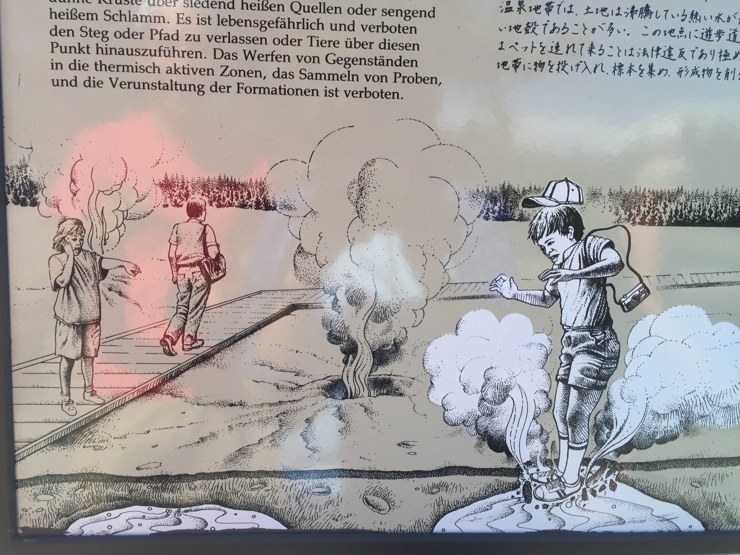
Fig. 4.7.5. Charlene Estrada. (2016). “Yellowstone Park Warning.” [Online Image]. Thriving Near Volcanoes. https://open.maricopa.edu/app/uploads/sites/119/2021/03/IMG_1281-scaled.jpeg CC BY.
- Bulletin warning to avoid stepping away from the solid pathways at Yellowstone National Park.
Fig. 4.7.6. Charlene Estrada. (2009). “Verde Hot Springs.” [Online Image]. Thriving Near Volcanoes. https://open.maricopa.edu/app/uploads/sites/119/2021/03/Pictures-off-my-camera-FINALLY-176-scaled.jpeg CC BY.
- Verde Hot Springs soaking pool in Northern Arizona.
Fig. 4.7.7. Man vyi. (2005, Jun 22).”Granite_wall_of_chapel_La_Hougue_Bie,_Jersey.” [Online Image]. Wikimedia Commons. https://commons.wikimedia.org/wiki/File:Granite_wall_of_chapel_La_Hougue_Bie,_Jersey.jpg Public Domain.
- Durable granite brick wall.
Fig. 4.7.8. NPS. (n.d.). “Interactive Exhibits.” [Online Image]. NPS. https://www.nps.gov/media/photo/gallery-item.htm?pg=1847695&id=D1593A2F-155D-451F-672B00006E2C7739&gid=D15939D5-155D-451F-67F912C611D91CC3 Public Domain.
- Sunset Crater Visitor Center Interactive Exhibit.
Fig. 4.7.9. Rxn111130. (2015, Dec 7). “Geothermal Energy.” [Online Image]. Wikimedia Commons. https://commons.wikimedia.org/wiki/File:Geothermal-energy.png CC BY-SA.
- Schematic explaining how volcanic activity/ geothermal energy can generate power.
Fig. 4.7.10. Gretar Ívarsson. (2006, Oct 6). “NesjavellirPowerPlant edit2.” [Online Image]. Wikimedia Commons. https://en.wikipedia.org/wiki/File:NesjavellirPowerPlant_edit2.jpg Public Domain.
- A geothermal power station found in Iceland.
Instructor Resources
DP22_Ch04_Volcanoes PDF Text only
