11.3 Thunderstorms
Thunderstorm Basics
A thunderstorm is defined as a storm that has lightning and thunder. Worldwide there are over 40,000 thunderstorms every day with the United States alone having 100,000 thunder-storms yearly. The essential ingredients for a thunderstorm are warm, moist, unstable air that is forced to rise either through convection, convergence, orographic uplift, or weather fronts. The rising parcel of air condenses into various types of cumulus clouds. (Dastrup, 2014)
Thunderstorm Genesis
All thunderstorms go through a three-stage lifecycle. The first stage is called the cumulus stage, where an air parcel is forced to rise, cool, and condense, called the lower condensation level, to develop into a cumulus cloud. The process of water vapor condensing into liquid water releases large quantities of latent heat, which makes the air within the cloud warmer, and unstable causing the cloud continues to grow upward like a hot air balloon. These rising air parcels, called updrafts, prevent precipitation from falling from the cloud. However, once the precipitation becomes too heavy for the updrafts to hold up, the moisture begins to fall, creat-ing downdrafts within the cloud. The downdrafts also begin to pull cold, dry air from outside the cloud toward the ground in a process called entrainment.
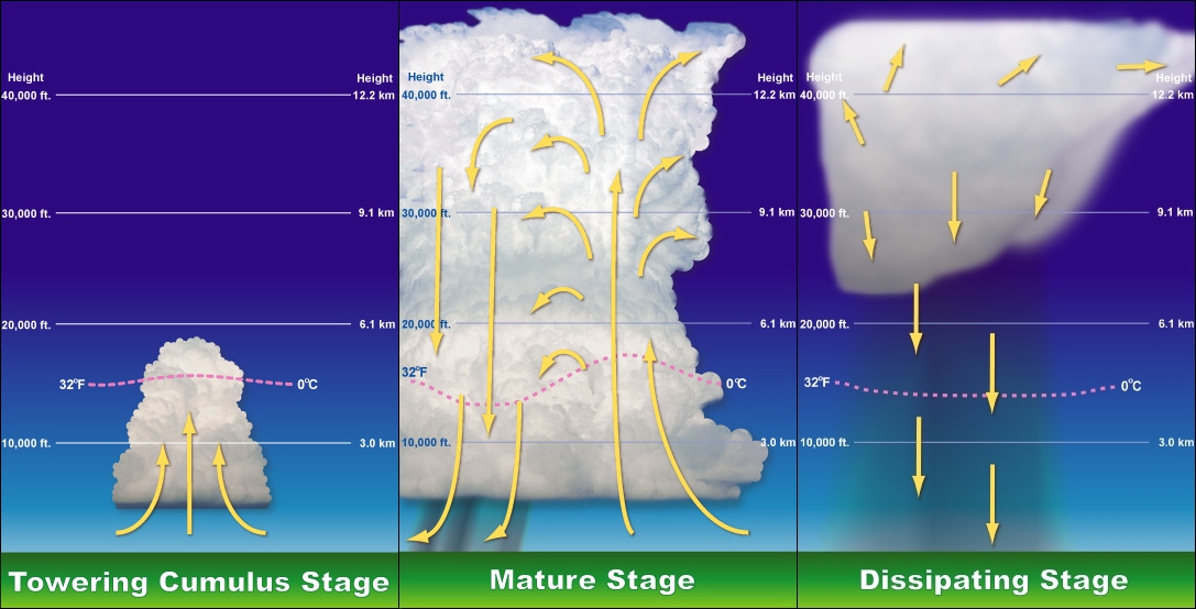
Once the precipitation begins to fall from the cloud, the storm has reached the mature stage. During this stage, updrafts and downdrafts exist side-by-side, and the cumulonimbus is called a cell. If the updrafts reach the top of the troposphere, the cumulus cloud will begin to spread outward, creating a defined anvil. At the same time, the downdrafts spread within the cloud and at first make the cloud more extensive, eventually overtaking the updrafts. Cold downdrafts form when precipitation and the cold air from entrainment are dragged down to the lower regions of a thunderstorm. It is also during the mature stage when the storm is most intense, producing strong, gusting winds, heavy precipitation, lightning, and possibly small hail.
Once the downdrafts overtake the updrafts, which prevents the release of latent heat energy, the thunderstorm will begin to weaken into the third and final stage, called the dissipating stage. During this stage, light precipitation and downdrafts become the dominate feature within the cloud as it weakens. Only twenty percent of the moisture within the cloud fell as precipitation, whereas the other eighty percent evaporates back into the atmosphere. (Dastrup, 2014)
Types of Thunderstorms
Air Mass Thunderstorms
There is a variety of thunderstorms, all with defined characteristics. Air mass thunderstorms, sometimes called ordinary thunderstorms, go through the defined lifecycle sequence mentioned earlier. As the word implies, air mass thunderstorms occur when a warm, moist (mT) mass of air from a source region such as the Gulf of Mexico migrates over the land like the Great Plains. However, rather than a large-scale storm system forcing the mT air mass upward, localized uplift such as convection, sea-breezes, or orographic uplift forces the moist air within the air mass upward.
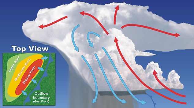
Most thunderstorms can also create other thunderstorms when downdrafts within a thunderstorm slam the ground and spread outward in an arc-shape. These rippling waves are called, outflow boundaries or gust fronts, because the cold air from the downdrafts acts like a mini-cold front. These mini-cold fronts can force warm air upward to generate new thunderstorms with cumulus development. On average, ordinary thunderstorms last about an hour. Ultimately, because of these outflow boundaries, an area may have several thunderstorms in various stages of development. These complex systems of thunderstorms can last several hours and are usually called multi-cell thunderstorms.
Severe Thunderstorms
The Storm Prediction Center classifies a severe thunderstorm as having winds that exceed 58 miles per hour or produces hail with a diameter of 1.9 centimeters. Of the 100,000 thunderstorms that develop within the United States’ experiences every year, about ten percent (10,000 storms) become severe thunderstorms. These can include air mass thunderstorms, squall lines, dryline thunderstorms, and supercells.
Severe thunderstorms go through the same stages as air-mass thunderstorms, but with one significant difference; severe thunderstorms last much longer in the mature stage. Ordinary thunderstorms do not last much longer than an hour because the downdrafts begin to cut off the updrafts. However, severe thunderstorms have vertical wind shear at different levels that keep the storm in the mature stage longer. This occurs when fast upper-level winds, such as the jet stream, causes the updrafts to pull away from the downdrafts. This prevents the downdrafts from cutting off the updrafts. Severe thunderstorms are capable of producing beautiful mammatus clouds, torrential downpours, flash flooding, large hail, lightning, and straight-line winds.
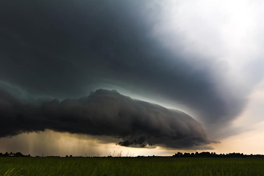
Squall lines are thunderstorms that develop linearly over hundreds of miles along the leading edge of outflow boundaries and are called gust fronts. Though these large storm systems are quite powerful, they do not tend to produce tornadoes. Rather, straight-line winds and precipitation form because of the powerful, horizontal movement of the gust front.
A squall line can also form along a boundary called a dryline. Recall from the section on mid-latitude cyclones, that the warm air in front of the cold front is usually an mT air mass. Sometimes a dry, warm cT air mass can penetrate the mT air mass and cP air mass. Drier air is denser than moist air, so when it infiltrates a storm system, it can cause the mT air mass to rise much like a cold front without the cold. The hallmark of a dryline is that the moisture within the air dramatically drops following the boundary. Drylines can produce severe thunderstorms that are often more powerful than the cold front behind it.

Supercells
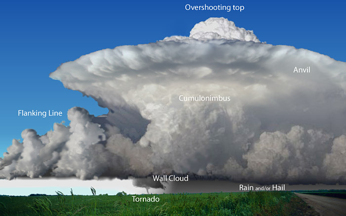
The most powerful thunderstorm is a supercell, which is oddly enough for a single-cell thunderstorm on steroids. The United States alone has anywhere from 2,000 to 3,000 super-cells a year. Supercells consist of a single powerful thunderstorm that can last several hours and grow to a height of 65,000 feet and last several hours in the mature stage with winds reaching over 100 mph and form the majority of all tornadoes.

Like severe thunderstorms, supercells may have upper-level winds that can pull the up-drafts away from the downdrafts. Wind shear between the upper-level, mid-level, and surface winds can also cause the air beneath a forming supercell to rotate. For example, if there are upper-level and mid-level winds flowing from the northwest and low-level, warm southern surface winds converging together, a corkscrew flow of air could develop. This rotating column of air is then picked up by the thunderstorm’s updrafts, causing the entire storm to rotate vertically, called a mesocyclone. Sometimes, the rotating portion of the supercell, the mesocyclone, can extend below the thunderstorm base, creating a cloud feature called a wall cloud.