
4.5 Where are the Volcanoes?
Charlene Estrada
Distribution of Volcanic Activity
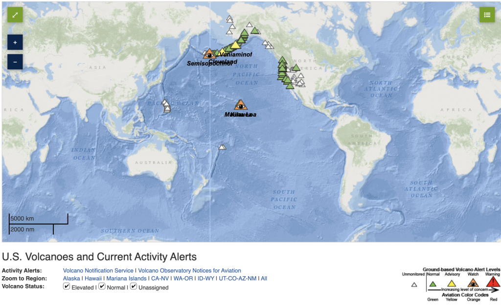
There are between 1400 and 1500 active volcanoes on our planet right now, and they are unevenly distributed throughout Earth’s surface. Some volcanoes cluster in specific regions. The Ring of Fire is an infamous area loosely spanning the border between continents and the Pacific Ocean (Fig. 4.5.3). This region spans about 40,000 kilometers and it has significantly more volcanic and seismic activity compared to other places on the planet.
Why are so many volcanoes bunched together? Tectonic processes form most volcanoes such as subduction at convergent boundaries or rifting at divergent boundaries. Therefore, the distribution of volcanoes naturally coincides with plate boundaries. This connection between volcanism and plate boundaries is called interplate volcanism. There are some volcanoes, however, that occur very far away from plate boundaries. They are typically the result of hot spot volcanism, which can occur on both continental and oceanic lithosphere.
Below, we will explore some of the broad geologic environments that result in volcanism and the types of volcanoes we might expect from each.
Mid-Oceanic Ridges
New lithosphere is continuously being formed at divergent boundaries. As two tectonic plates spread apart, the magma from the asthenosphere will rise to the surface and form brand new oceanic crust made of basalt and gabbro. The Mid-Atlantic Ridge exemplifies this process, and it is Earth’s longest mountain range! There are two sets of divergent boundaries at the Mid-Atlantic Ridge: the North American-Eurasian plate boundary to the north and the South American-African plate boundary to the south. Such a long spreading center along the ocean floor is responsible for the majority of Earth’s volcanism, but because it is deep underwater, it poses little to no risk to society.

Continental Rifts
The lithosphere spreads in mid-ocean ridges and in the continents! Although the continental lithosphere can be up to 100 km thick, divergent tectonic forces can break it apart. As a result, the continental crust will thin over time, and the lower layers of the crust and the mantle will rise because they are buoyant. These uprising rocks in the lower lithosphere and mantle undergo decompression melting (section 4.1) and basaltic magma will erupt from newly created volcanoes. The spread-apart regions on continents are called continental rift valleys. Most continental rift valleys form at divergent boundaries where ocean basins have not yet opened. These places are sites of continental break-up, and we can see this process occurring today at the East African rift.
Convergent Boundaries

Recall from Ch. 2 that in convergent boundaries between two oceanic plates or between an oceanic and continental plates, the denser oceanic lithosphere sinks toward the mantle. Within the subduction zone, magma will form due to flux melting (Section 4.1).
The magma generated at the subduction zone is derived from the mantle and thus shares the same chemical composition; it is mafic. Mafic magmas typically have higher temperatures than felsic magmas, they are hotter. If this mafic magma rises toward a continental plate, which is felsic in composition, it will melt parts of it. This is because the continental crust melts at lower temperatures than the oceanic crust, so the mafic magma can melt the felsic crust and mix with it. The new melt will have a different composition, it will become intermediate between mafic and felsic, or even felsic as more continental crust gets mixed and melted into it. The result is a very viscous magma that will produce stratovolcanoes. Stratovolcanoes typically form at convergent boundaries. The Pacific Ring of Fire, a continuous subduction zone, receives its name due to the abundance of these explosive volcanoes.
A description of the Pacific Ring of Fire along western North America is below (Fig. 4.5.3):
- Subduction at the middle American trench creates volcanoes in Central America.
- The San Andreas fault is a transform boundary.
- Subduction of the Juan de Fuca plate beneath the North American plate creates the Cascade volcanoes like Mount St. Helens, Mount Rainier, Mount Hood, and more.
- Subduction of the Pacific plate beneath the North American plate in the north creates the long chain of the Aleutian Islands volcanoes near Alaska.
Hot Spots
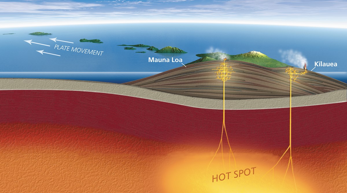
A volcanic “hotspot” is an area in the mantle from which heat rises as a thermal plume from deep in the Earth. High heat and lower pressure at the base of the lithosphere (tectonic plate) facilitates melting of the rock. This melt, called magma, rises through cracks and erupts to form volcanoes. As the tectonic plate moves over the stationary hot spot, the volcanoes are rafted away and new ones form in their place. This results in chains of volcanoes, such as the Hawaiian Islands (Video 4.5.1, from IRIS and Fig. 4.5.4). These islands are usually just “the tip of the iceberg” as they are often very large shield volcanoes that lie under the water (Fig. 4.5.4). Shield volcanoes form by low-viscosity, mafic magma.
Video 4.5.1 Hotspot track animation. Observe the movement of the oceanic plate while the thermal plume remains in place.
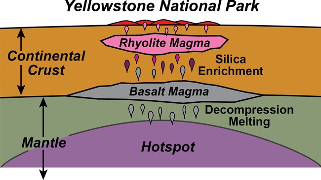
Some hot spots form beneath the continental lithosphere. Although the partially melted mantle composition is ultramafic at depth, as it rises to the surface and mixes with the materials in within the continental crust, it becomes mafic, then intermediate. In some areas, it might even become felsic. This mixing of molten materials is a recipe for potential disaster! As the magma becomes more silica-rich, it also becomes more viscous with volatile gases, which make for a very explosive eruption. In the United States, there is one active continental hot spot volcano we are currently monitoring: the Yellowstone Caldera (above), which is likely to have a super-volcanic eruption in the next 100,000 years.
Backyard Geology: Sunset Crater National Monument Park
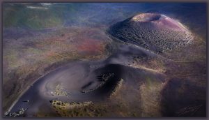
The Sunset Crater National Monument Park is a site of fairly recent volcanic activity (geologically-speaking!). The park encompasses two cinder cone volcanoes; the Sunset Crater Volcano and Lenox Crater Volcano which have produced basaltic lavas and scoria from their previous eruptions. The last eruption from Sunset Crater was about 950 years ago, and it was said to result in lava fountains that were nearly 3 times higher than the Statue of Liberty. Even though Sunset Crater erupted in the past 1000 years, we classify it as extinct and we do not expect it to erupt again as the plate has since moved eastward. We call it the “Sunset Crater” because mafic igneous rocks such as scoria have a lot of iron in them that easily rusts or oxidizes under Earth’s atmosphere from their original blackish-gray color to bright reds and purples, and pinks [10].
A volcano that has erupted at least once over the past 10,000 years and has the possibility of erupting in the future.
A region extending along the islands and coastlines bordering the Pacific ocean that is affected by convergent and transform plate boundaries. These boundaries cause a higher incidence of earthquakes and volcanoes.
Vibrations and energetic waves produced by the movement within Earth's crust and interior.
The process in which the older, denser tectonic plate at a convergent boundary will buckle and sink into the lithosphere. This plate will always be composed of oceanic lithosphere.
A region along Earth's lithosphere where at least two tectonic plates collide with one another.
an area on a continent where there is an active divergent boundary stretching and tearing the landmass apart.
A region along Earth's lithosphere where at least two tectonic plates move apart from one another.
volcanic activity that occurs between active tectonic plate boundaries.
A type of volcanic activity, that occurs independent of plate boundaries, in which a plume of molten magma from deep within the mantle upwells at the Earths surface.
The outer, relatively rigid layer of the Earth that is composed of crust and upper mantle.
molten rock that can be found beneath the Earth's surface.
A ductile but solid, hot layer in the Earth composed of the lower crust and upper mantle that flows like putty over long periods of time. It drives the movement of the rigid tectonic plates riding above.
A type of rigid, thin crust made of iron and magnesium rich minerals that is found beneath the planet's oceans.
an igneous rock that is mafic and fine-grained. Basalt is dark and makes up the majority of the oceanic crust.
A mafic, coarse-grained igneous rock that is often dark-colored. Gabbro makes the majority of the Earth's oceanic crust beneath the surface.
The world's longest mountain chain found beneath the Atlantic ocean between North America, South America and Europe and Africa. The Mid-Atlantic Ridge is an example of a mid-ocean ridge, or MOR.
A region on the ocean floor where magma from an active divergent boundary is creating new oceanic lithosphere, thus pushing or spreading the older lithosphere outwards.
(sometimes abbreviated as "MORs" by scientists) an underwater mountain ridge in the middle of the ocean that is formed by seafloor spreading centers at divergent boundaries.
A hot interior layer of solid rock between the crust and core that is capable of plastic flow. The mantle is the largest layer of Earth.
The process in which solid rock melts upon experiencing a sudden decrease in pressure, but not temperature.
a process in which solid rock melts because volatiles such as water vapor have caused its melting point to decrease.
Originating from an iron and magnesium-rich magma/lava composition.
A composition of igneous rocks, magma, and lava that is between felsic and mafic.
originating from a feldspar and silica-rich magma/lava composition.
A tall and steep conically-shaped volcano built upon past layers of hardened ash and lava flows. Also known as a composite volcano.
A region along Earth's lithosphere where at least two tectonic plates slide past one another.
A large type of volcano characterized by broad, shallow slopes formed by low-viscosity mafic lava flows.
a liquid's resistance to flow or movement
A magnesium and iron rich rock that contains very little silica.
Thick crustal material mostly made of feldspar and silica rich minerals which forms the world's large landmasses.
a compound composed of silicon and oxygen in the formula SiO2.
Gases dissolved within magma or lava.
A small type of volcano that is cone-shaped, steep, and built from mafic ash cinders and large volcanic rocks.
A mafic, vesicular igneous rock. Scoria is dark-colored, extrusive, and contains many cavities. However, it cannot float on water.
A volcano that is not currently erupting and is not expected to erupt in the future.
