
14.2 Water Pools and the New Water Cycle Diagram
Katherine J. Megivern
Recall the water, or hydrologic, cycle. (See Figure 14.0.1.) The major water pools, or storage locations, on Earth are oceans, glaciers, groundwater, streams (rivers), lakes, and wetlands. Water spends different amounts of time in the various pools. The water cycle represents a continuous global cycling of water from one pool to another.
As we examine various pools, it is important to not compartmentalize our thinking about each one, but to remember that water moves from one to another. For this, it would be good to see the USGS New Water Cycle Diagram. Click here for the online zoomable version. (It is also shown at the end of this section.)
The previous update, which opened this chapter, was a colorful, appealing diagram released in 2000. Why the update? Compare the two versions and see if you can find some possible explanations. We’ll get back to this after taking a look at several pools.
Streams
Streams are bodies of water that are in constant motion. Geologists recognize many categories of streams depending on their size, depth, speed, and location. For example, rivers, creeks, and brooks are all types of streams.
The U.S. has numerous streams, or rivers, that run throughout the nation’s landscape. It is estimated that the U.S. has over 200,000 rivers, with the Mississippi River being the largest by volume despite it being only the second longest. The Missouri River is the longest river in the U.S.
Backyard Geology: Arizona Streams
In Arizona, the main rivers are the Colorado (which runs through the Grand Canyon), the Gila, the Salt (or Rio Salado), and the Verde. There are also several smaller streams, some of which only flow during wet periods.
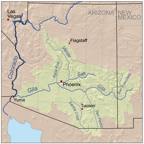
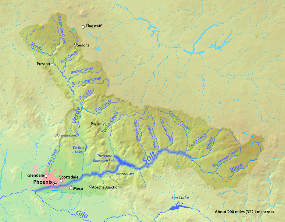
Figure 14.2.2. The Salt River (Rio Salado) and its tributaries.
Stream basics were discussed in Chapter 6.1 of Dynamic Planet. This stream section of Chapter 14 will focus mainly on stream pollution.
Major cities, communities, factories, industries, and power stations are often located along streams. It is important to also note that streams contain important biological communities and provide opportunities for recreation such as swimming, fishing, and white water rafting. It is therefore very important to protect the quality and integrity of rivers all over the world.
Unfortunately, most of the rivers in the world are too polluted to support certain human activities, especially swimming, fishing, and drinking. Close to half of the rivers in the US have been deemed too polluted to support swimming and fishing.
A couple of generations have now lived their lives with recommendations in place on safe serving sizes of different types of fish and shellfish, recommendations on the frequency at which they may safely be consumed, and similar information for specific bodies of water. (This includes lakes as well as streams.) It is important to remember that such recommendations have not always been necessary. And they are not due to our simply learning more and discovering an inherent, natural problem with our aquatic ecosystems. Healthy aquatic ecosystems do not necessitate health warnings. The recommendations are due to health organizations acting responsibly upon the emergence of health issues tied largely to polluting actions of humans. Even now with greater understanding of natural systems and our effects on them, too many negative changes remain.
Evidence regarding the role of humans in water pollution was supported during the Covid-19 pandemic. At this National Institute of Health site is a remarkable read on the pandemic’s positive influence on virtually all types of pollution. Example after example will drop your jaw and should give us hope that it is not too late for nature to heal. Note this statement from that article: “Millions of the people have been cooped up indoors but the natural world outside has continued to rumble on and the natural world is benefiting from our absence.”
Besides pollution, many rivers have also been channelized, dredged, or impounded by dams which have decreased their ability to support human and biological activities. The benefits and detrimental effects of damming of streams is thoroughly discussed in this book’s chapter 10.8.
Lakes, Reservoirs, and Ponds
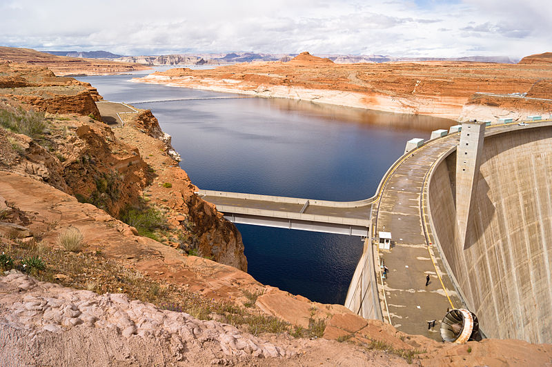
If water flows to a place that is surrounded by higher land on all sides, a lake will form. A lake, pond or reservoir is a body of standing water on the land surface. When people build dams to stop rivers from flowing, the artificial lakes that form are called reservoirs (Figure 14.2.3).
It is estimated that over 300 million water bodies in the world are lakes, reservoirs, and ponds. Most of the Earth’s lakes (about 60%) are found in Canada. Even though lakes and rivers contain less than 1% of the Earth’s water, the US gets over two thirds (70%) of its water (for drinking, industry, irrigation, and hydroelectric power generation) from lakes and reservoirs. Lakes are also the cornerstone of the US’s freshwater fishing industry and are the backbone of the nation’s state tourism industries and inland water recreational activities. Arizona is home to over 100 reservoirs, but only two natural lakes, Mormon Lake and Stoneman Lake, both in northern Arizona.
Ponds are small bodies of freshwater that usually have no outlet; ponds are often are fed by underground springs. Lakes are more substantial bodies of water. Lakes are usually freshwater, although the Great Salt Lake in Utah is just one exception. Water usually drains out of a lake through a river or a stream, and all lakes lose water to evaporation.
Large lakes have tidal systems and currents, and can even affect weather patterns. The Great Lakes in the United States contain 22 percent of the world’s fresh surface water. The largest of them, Lake Superior, has a tide that rises and falls several centimeters each day. The Great Lakes are large enough to alter the Northeastern United States’ weather system by the “lake effect,” which is an increase in snow downwind of the relatively warm lakes. The Great Lakes are home to countless species of fish and wildlife.
Lakes form in various ways: in depressions carved by glaciers, in calderas, and along tectonic faults, to name a few. Subglacial lakes can even be found below an ice cap. As a result of geologic history and the arrangement of landmasses, most lakes are in the Northern Hemisphere.
“Limnology” translates directly as the “study of lakes” but in practice, also includes inland reservoirs, ponds, streams, groundwater, and wetlands, whether freshwater or saline. Their ecosystems are studied, including biological physical, chemical, and geological aspects.
The ecosystem of a lake is divided into three distinct zones:
- Surface (littoral) zone–the sloped area closest to the edge of the water. Sunlight promotes plant growth, which provides food and shelter to animals such as snails, insects, and fish.
- Open-water zone (also called the photic or limnetic zone)– has abundant sunlight. Other plant species are adapted to this zone, as are fish species such as bass and trout.
- Deep-water zone (also called the aphotic or profundal zone)–has little or no sunlight, and therefore no photosynthesis. Most deep-water organisms are scavengers, such as crabs and catfish that feed on dead organisms that fall to the bottom of the lake. Fungi and bacteria aid in the decomposition in the deep zone. Though different creatures live in the oceans, ocean waters also have these same divisions based on sunlight with similar types of creatures that live in each of the zones.
Lakes are not permanent features of a landscape. Some come and go with the seasons, as water levels rise and fall. If the springs or streams that fill them diminish, if their outlets grow because of erosion, or when the climate of an area changes, lakes can either expand or shrink. Even when lakes persist for many years, in temperate areas with distinct seasons, they’re quite dynamic, undergoing internal changes as shown in this video:
Video 14.2.1. Layers within a lake and how they change with the seasons. (1:40)
Over a longer time, lakes disappear when they fill with sediments as part of their life cycle:
Video 14.2.2. How a lake changes through time. (6:24)
And when the system is overloaded…
Video 14.2.3. A good explanation of lake eutrophication when there are too many nutrients in a lake. (3:48)
Next time you’re at a lake, look for signs of aging in a lake, and of eutrophication.
Video 14.2.4. An excellent 1-minute summary of eutrophication. (1:03)
Groundwater
Almost 99% of Earth’s available freshwater is found below the surface as groundwater. When precipitation falls, some of the water runs off on the surface while some infiltrates into the ground, to be stored in porous rock layers. Groundwater is replenished when water moves from the surface, through unsaturated rocks or sediment (unsaturated zone), all the way down to the saturated parts (saturated zone) in a process called infiltration and becomes groundwater. (See Figure 14.2.4 below.)
It can be difficult to visualize water underground. Some people believe that groundwater just collects in underground lakes or flows in underground rivers. Ground water does flow, but it is simply the subsurface water that fully saturates pores or cracks in soils and rocks that flows.
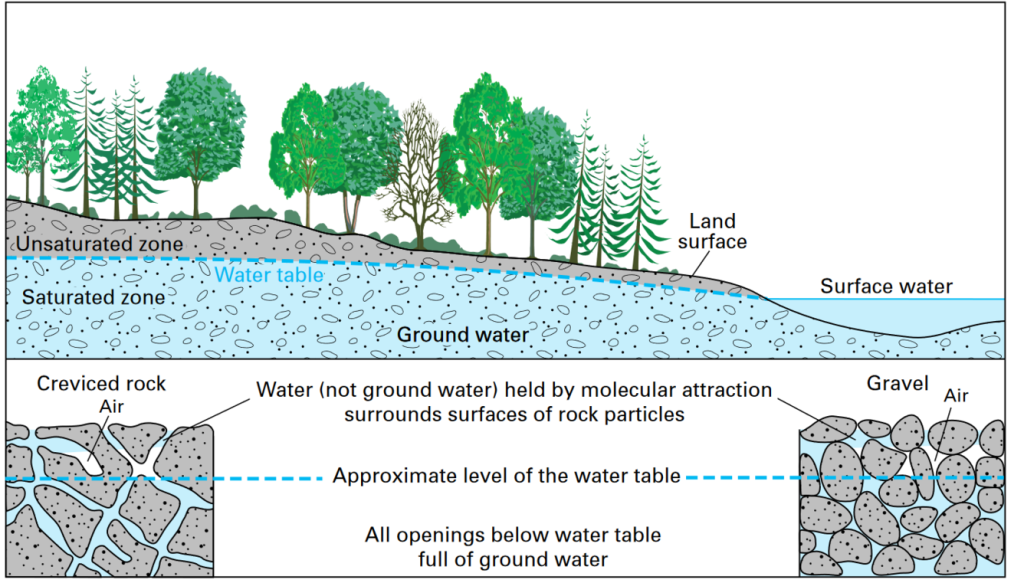
The top of the saturated portion is called the water table, which is the boundary between the saturated and unsaturated zones. Groundwater is found in aquifers, which are bodies of rock or sediment that store (and yield) large amounts of usable water in their pores. Groundwater will continue to flow until it emerges as a spring, or discharges into surface water bodies on the land or in the ocean.
Aquifer productivity is controlled by porosity and permeability. Porosity is the percentage of open space in a rock or sediment body. Permeability is the ability of subsurface material to transmit fluids through its interconnected spaces. Groundwater is found in the saturated zone of a rock body where all pores are filled with water.
To utilize groundwater, we drill holes (wells) into the ground and pump the water out. Groundwater is a renewable resource because it is naturally replenished by precipitation. But it can become nonrenewable if the water is removed faster than it can be replenished. This is a major environmental concern in many arid regions, such as the American West.
This is an ongoing critical issue for Arizona that has really come to the forefront in the early 2020s. This is one quick recap from early 2023:
Video 14.2.5. Summary of Arizona’s water crisis as of early 2023. (2:38)
And in 2023, research results reported that groundwater withdrawal has been so extensive that it has affected the orientation of Earth’s axis of rotation!
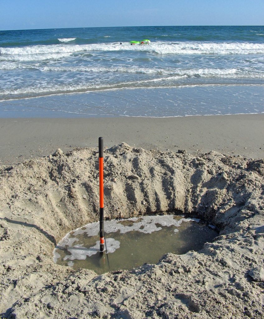
Study the diagram and caption below for an example of what can result, on a smaller scale, when groundwater is pumped out faster than it can be replenished.
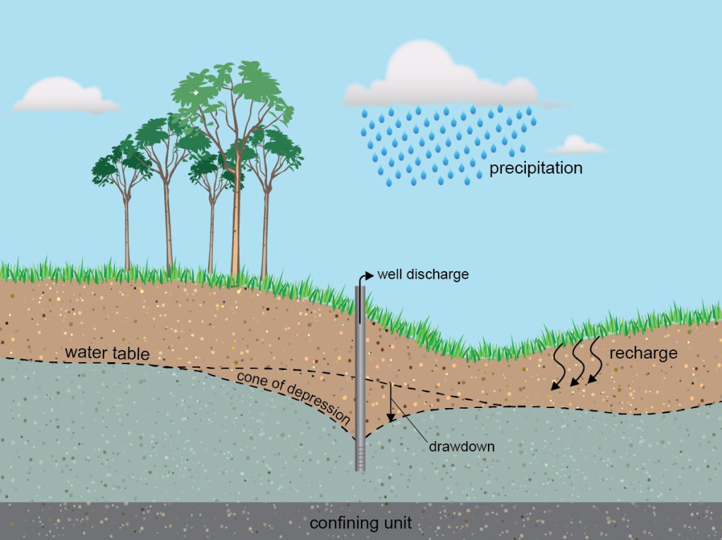
Groundwater rates of flow vary depending on porosity and permeability of the host rock or soil, from roughly several meters in a day to a few centimeters in a century. So water generally moves faster on Earth’s surface than it does underground, and therefore cones of depression are not rare where wells are dug.
Study Figure 14.2.7 below:
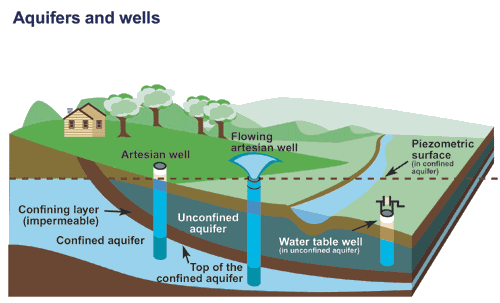
The deeper the water in the confined aquifer, the greater the pressure it experiences. This is the reason that water is able to flow or shoot out of the ground from the flowing artesian well. Note the piezometric surface, which is the level to which water will rise in a well drilled into the confined aquifer.
Groundwater is responsible for karst landscapes, or karst topography, that include a number of fascinating phenomena formed by dissolution of rock by groundwater. Below is a series of short videos that together highlight a number of these features.
Video 14.2.6. Good overview of groundwater, springs, and geysers, with a number of southwest U.S. examples. (7:17)
Video 14.2.7. Karst landscape features (including springs, sinkholes, disappearing streams, and caves) and drinking water are discussed in the following southeast Minnesota-based video. (2:43)
Video 14.2.8. It all comes together in this last very engaging video: suspense, the water cycle, limestone, world’s largest cave by volume, and more! (7:20)
The USGS New Water Cycle Diagram Revisited
Before moving on to wetlands, let’s delve further into this water cycle diagram. In the intro to this section, you were asked to compare the old and new diagrams and come up with reasons the diagram may have been updated. What did you come up with?
Well, the USGS created a video to accompany the release of the new diagram, and near the beginning, the USGS explains the reasons for the update. Watch the video from 9:20-13:37 and then answer the questions below. (Note that “Drippy” is a cartoon character working its way through the parts of the water cycle being discussed!)
Now that we’ve discussed streams, lakes, and groundwater, watch 24:26-30:14 for a look at interrelationships between surface waters and groundwater and scientists’ investigations, then answer the questions that follow.
Continuing to 46:03 is an interesting narration as Drippy continues through many parts of the water cycle, including those parts subject to a lot of human influence. There are no questions covering this, but it is interesting.
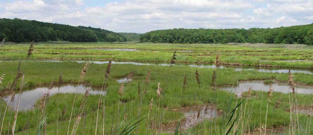
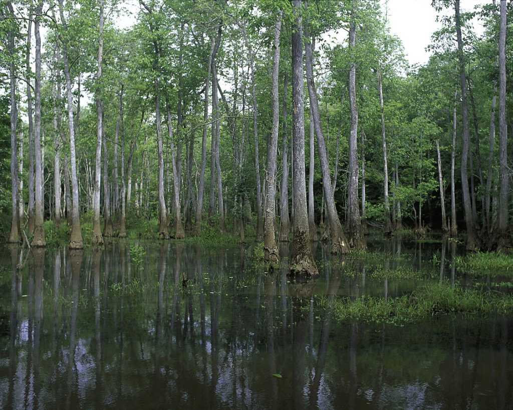
Wetlands
Wetlands, such as swamps and bogs, are lands that are wet for significant periods. Wetlands are common where water and land meet and can range from large flat areas to small and steep areas. The water table is high, soils are saturated for a large part of the year, and standing water is common. Wetland plants require large amounts of water to survive, or must at least be able to tolerate having their “feet” wet for extended periods.
Wetlands are vibrant and unique ecosystems with many specialized species that rely on both the land and the water for survival. Even though many species are specialized, with the abundant water and high levels of soil nutrients characteristic of wetlands, these are very important areas of productivity and biological diversity. In other words, wetlands produce a great deal of food that supports a wide variety of species. An example of this biodiversity is that one third of all American bird species can be found in wetlands.
Types of Wetlands
There are a variety of distinct types of wetlands, such as swamps, marshes, and bogs, to name just a few. Marshes are shallow wetlands around lakes, streams, or the ocean where grasses and reeds are common, but trees are not. Frogs, turtles, muskrats, and many varieties of birds are at home in marshes.
A swamp is a wetland with lush trees and vines found in a low-lying area beside slow-moving rivers. Like marshes, they are often or always inundated with water. Since the water in a swamp moves slowly, oxygen in the water is often scarce. Swamp plants and animals must be adapted for these low-oxygen conditions. Like marshes, swamps can be freshwater, saltwater, or a mixture of both.
In an estuary, salt water from the sea mixes with fresh water from a stream or river. These semi-enclosed areas are home to plants and animals that can tolerate the sharp changes in salt content that the constant motion and mixing of waters create. Estuaries contain brackish water, which is water that has a higher concentration of salt than freshwater but a lower salt concentration than seawater. Because of the rapid changes in salt content, estuaries have many different habitats for plants, animals, and extremely high biodiversity.
Ecological Role of Wetlands
As mentioned above, wetlands are home to many varied species of organisms. Although they make up only 5 percent of the United States area, wetlands contain more than 30 percent of the plant types. They supply safe, hidden protection for hatchlings. Many endangered species live in wetlands, so wetlands are protected from human use. In turn, wetlands offer protection from storm surges including tropical storm systems like hurricanes. They provide flood control, with sponge-like capabilities, and help recharge groundwater. Wetlands also play a critical biological role by removing pollutants from water. They act as filters for storm-water runoff before it enters rivers and lakes by trapping fertilizer and pesticides from farm fields. These are also important areas where geochemical and biological cycles/ processes are consistently taking place. For instance, wetlands are as areas of significant carbon sequestration (storage), which impacts global climate change.
Wetland ecosystems can be fragile systems sensitive to the amounts and quality of water present within them, however. Unfortunately, trapping pollutants before they contaminate other bodies of water means that the wetlands themselves become polluted, compromising the many benefits they offer. Learn more about wetlands at the U.S. Environmental Protection Agency wetland site.
Before the value of wetlands were understood, they were often drained and/or “filled in” for agriculture, roads, and building. To illustrate the extent of wetland destruction, consider Iowa, which depending on the authority, is the most altered or second-most altered state in the United States. Before alterations that accompanied settlement in the 1800s, Iowa was 25% wetlands. Less than 5% of that remains today. (Wetlands incurred less destruction in Iowa than its prairies, however, of which less than 0.1% remains.)
At times, when wetlands have been found to be in an inconvenient place with respect to human plans, they were “moved;” that is, usually destroyed and a new wetland built at another site. This however is a very inadequate attempt at remediation. The many species that call the wetland home are part of intricate food webs, developed in the context of certain geologic and climatic conditions. These relationships require a great deal of time to develop, varying with type of wetland, from tens to hundreds to thousands of years. What can be done? One, treat wetlands as non-negotiables–preserve them. And two, start ASAP on rehabilitating or restoring wetlands that have been weakened or destroyed.
Backyard Geology: Fen Restoration at Little Green Valley, Arizona
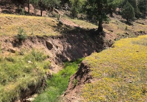
Figure 14.2.11. 2020 photo of the gully that lowered the groundwater table, drying out the former fen.
By 2022, restoration efforts had begun on this fen, an important part of a larger Tonto National Forest watershed restoration. Fens are similar to bogs. Both form peat, but while the water in bogs comes from rain, in fens the water source is groundwater. Read a March 2022 update here.
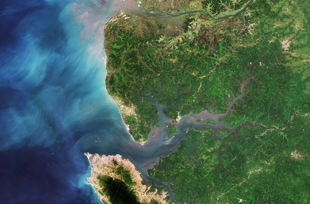
Ocean
The ocean, with its named components (Atlantic, Pacific, etc.), plays a huge role in the water cycle and makes crucial contributions to life on Earth. It deserves a well-written section of its own, and it already exists–as a full chapter, Chapter 8, in this book!
Glaciers
Glaciers are found where snowpack doesn’t melt completely from year to year and compacts to form ice that moves under its own weight. The New Water Cycle Diagram includes an interesting section on snowpack at 16:55-24:24. Watch and answer the questions below.
As you can see, glaciers definitely have a place in this book on geological disasters and the environment, but this will be a short section, at least for the time being, partly because we don’t pollute them as we do other water reservoirs. Interestingly, they hold records in their ice layers of changes on Earth, including those that correlate with certain environmentally-destructive human activities.
We don’t pollute glaciers, per se, but we do cause them great harm. With our many polluting activities, we are changing the climate, increasing glacial melting at unprecedented rates. Because glaciers are a major water pool and part of the water cycle, the impacts of this melting are tremendous, from rising sea level and accompanying coastal flooding to changes in ocean circulation…think about what it is that the ocean circulates…heat, nutrients, pollutants, and so much more.
Watch for Dynamic Planet’s related upcoming chapters: Weather Systems and Severe Weather, and Global Climates and Change.
