
7.5 Attribution and References
Creative Commons Attribution for Text
(1) Physical Geology – 2nd Edition by Steven Earle is licensed under CC BY 4.0.
(2) United States Geological Survey (USGS) is licensed under Public Domain.
(3) Natural Disasters and Human Impacts by R. Adam Dastrup, MA, GISP is licensed under CC BY-NC-SA 4.0
(4) An Introduction to Geology by Chris Johnson, Matthew D. Affolter, Paul Inkenbrandt, Cam Mosher is licensed under CC BY-NC-SA 4.0
(5) Arizona Geological Survey. (AZGS) is licensed under CC-BY 4.0
Media Assets
All images, videos, animations, and H5P activities within this chapter are licensed under Creative Commons, or in rare circumstances, Fair Use.
Arizona State Geological Survey (n.d.) Retrieved April 19, 2021 from https://youtu.be/w8bRRixHe3g
- Photographs of recent landslide deposits in Arizona.
7.1
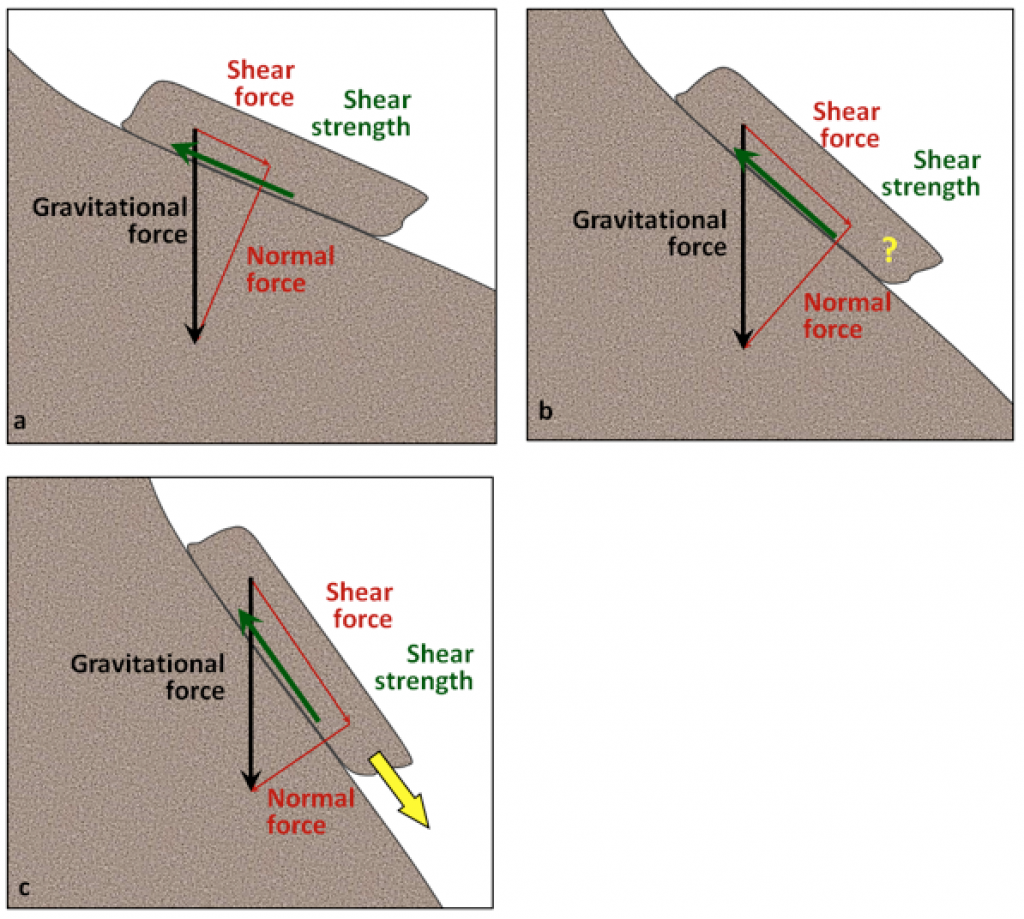
7.1.1 Earle, S. (n.d.) Retrieved April 21, 2021 from https://opentextbc.ca/physicalgeology2ed/wp-content/uploads/sites/298/2019/06/Differences-in-the-shear-and-normal-components-1024×919.png
- Differences in the shear and normal components of the gravitational force on slopes with differing steepness. The gravitational force is the same in all three cases.
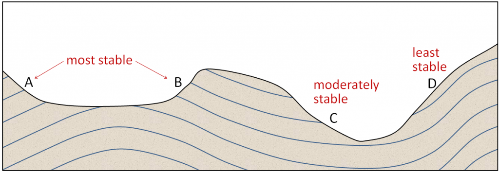
7.1.2 Earle, S (n.d.) Retrieved April 21, 2021 from https://opentextbc.ca/physicalgeology2ed/wp-content/uploads/sites/298/2019/08/Relative-stability-of-slopes-as-a-function-of-the-orientation-of-weaknesses-1024×356.png
- Relative stability of slopes as a function of the orientation of weaknesses (in this case bedding planes) relative to the slope orientations.
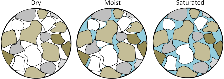
7.1.3 Earle, S (n.d.) Retrieved April 21, 2021 from https://opentextbc.ca/physicalgeology2ed/wp-content/uploads/sites/298/2019/08/Depiction-of-dry-moist-and-saturated-sand.png
- Depiction of dry, moist, and saturated sand.
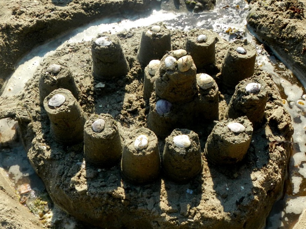
7.1.4 Earle, S (n.d.) Retrieved April 21, 2021 from https://opentextbc.ca/physicalgeology2ed/wp-content/uploads/sites/298/2019/08/Sand-and-Water-1024×768.jpg
- Photograph of sand castles
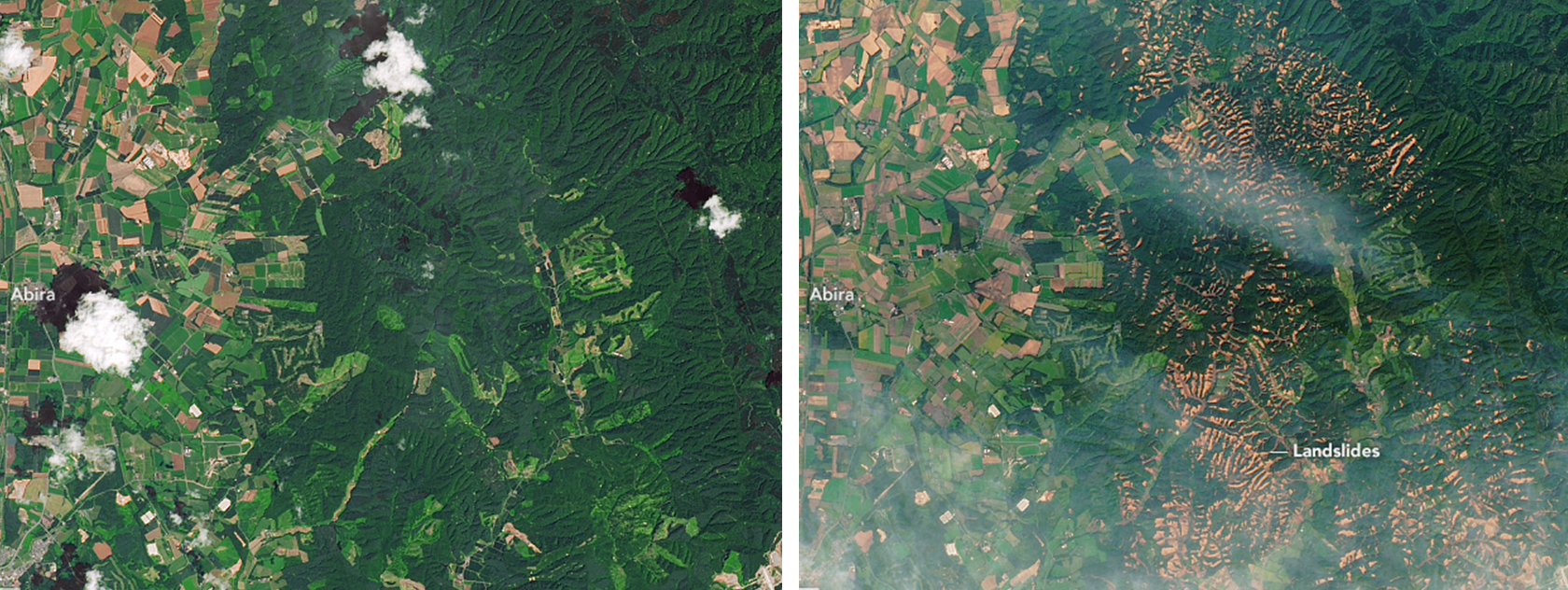
7.1.5 Retrieved April 21, 2021 from https://opentextbc.ca/physicalgeology2ed/wp-content/uploads/sites/298/2019/08/hokkaido-slides.png
- Satellite images of slope failures in the Sapporo area of Japan following a typhoon and earthquake.
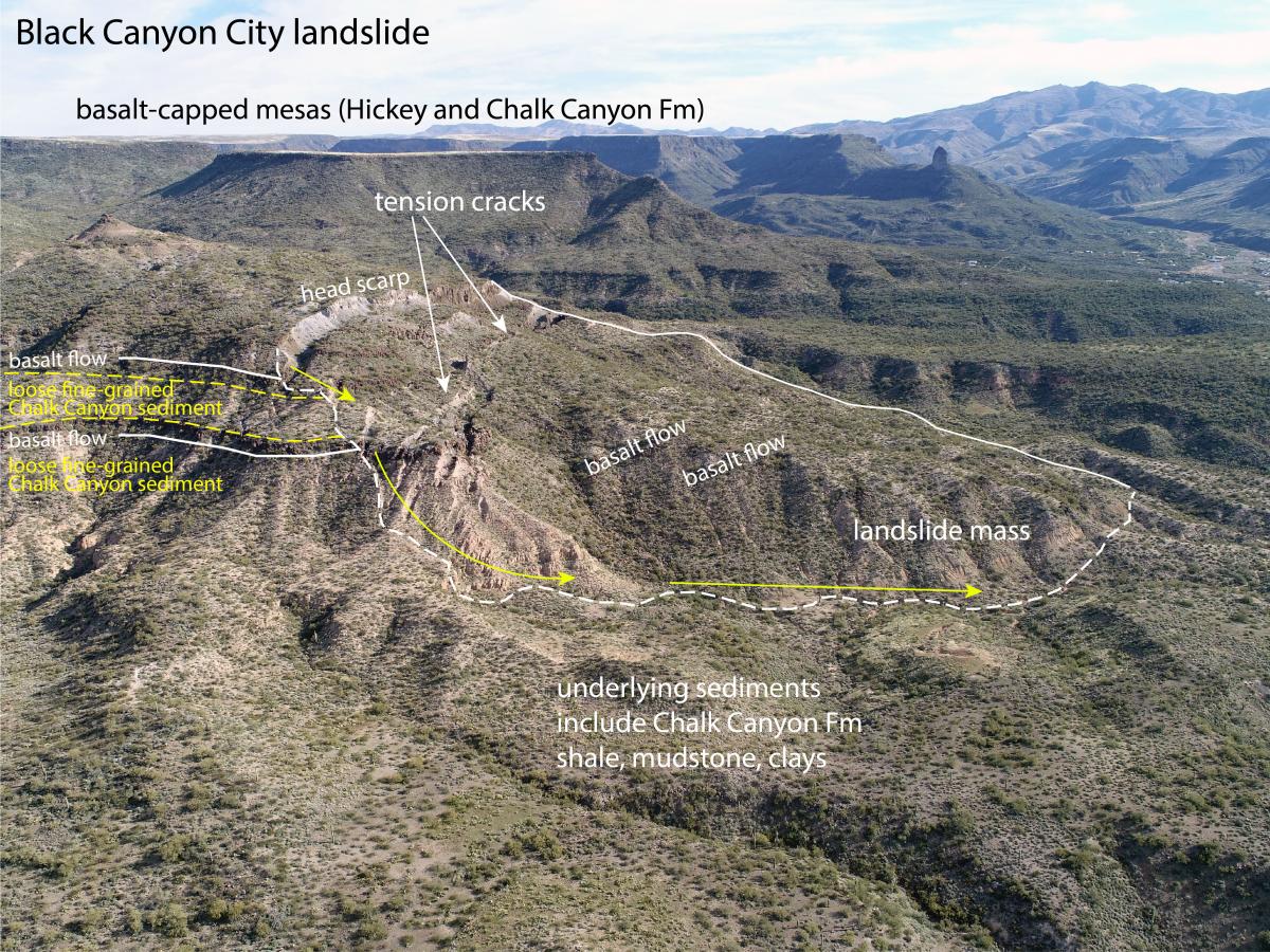
7.1.6 Gootee, B & Cook, J. (2020) Black Canyon Landslide, Annotated. Retrieved April 22, 2021 from https://azgs.arizona.edu/sites/default/files/styles/azgs_optimized_large/public/azgs-photo-gallery/BlackCanyon_anno3_reduced_5.jpg?itok=ahySUJQK
- Annotated image of Black Canyon Landslide, AZ
Table 7.1 Earle, S (n.d.) Retrieved April 22, 2021 from https://opentextbc.ca/physicalgeology2ed/chapter/15-2-classification-of-mass-wasting/#skiptable15.1
- Table showing classification of slope failures based on type of material and type of motion.
7.2
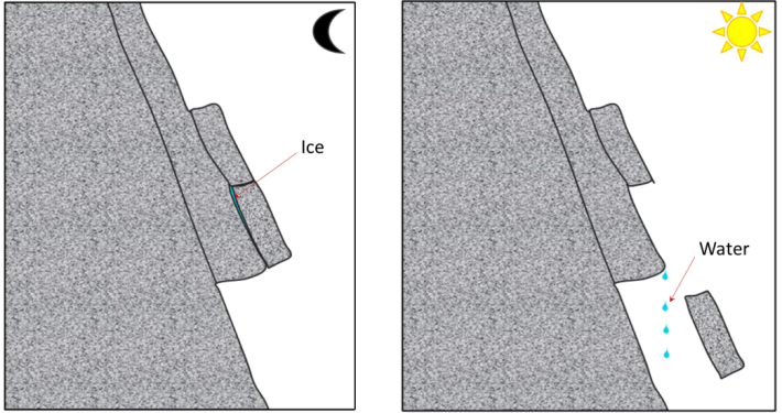
7.2.1 Earle, S. Retrieved April 22, 2021 from https://opentextbc.ca/physicalgeology2ed/wp-content/uploads/sites/298/2019/06/contribution-of-freeze-thaw-to-rock-fall.png
- The process of freeze/thaw causing a rock fall.
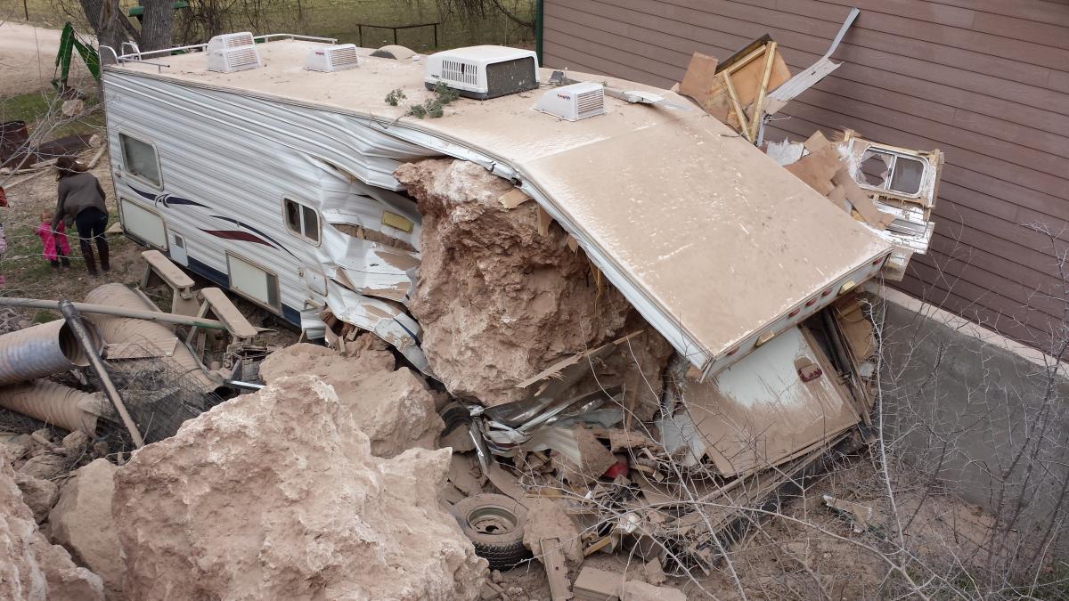
7.2.2 AZGS (n.d). Retrieved April 22, 2021 from https://azgs.arizona.edu/sites/default/files/styles/azgs_optimized_large/public/azgs-photo-gallery/rimrock%20rock%20fall%204-7-14.jpg?itok=NEiaHwYv
- An image of a boulder smashed into the side of an RV in Verde Valley, AZ, after a rock fall.
7.2.3 USGS (n.d.) Retrieved April 22, 2021 from https://opengeology.org/textbook/wp-content/uploads/2016/07/10.4_Gros_Ventre-Cross-section.jpg
- Cross-section of 1925 Gros Ventre slide showing sedimentary layers parallel with the surface and undercutting (oversteepening) of the slope by the river.
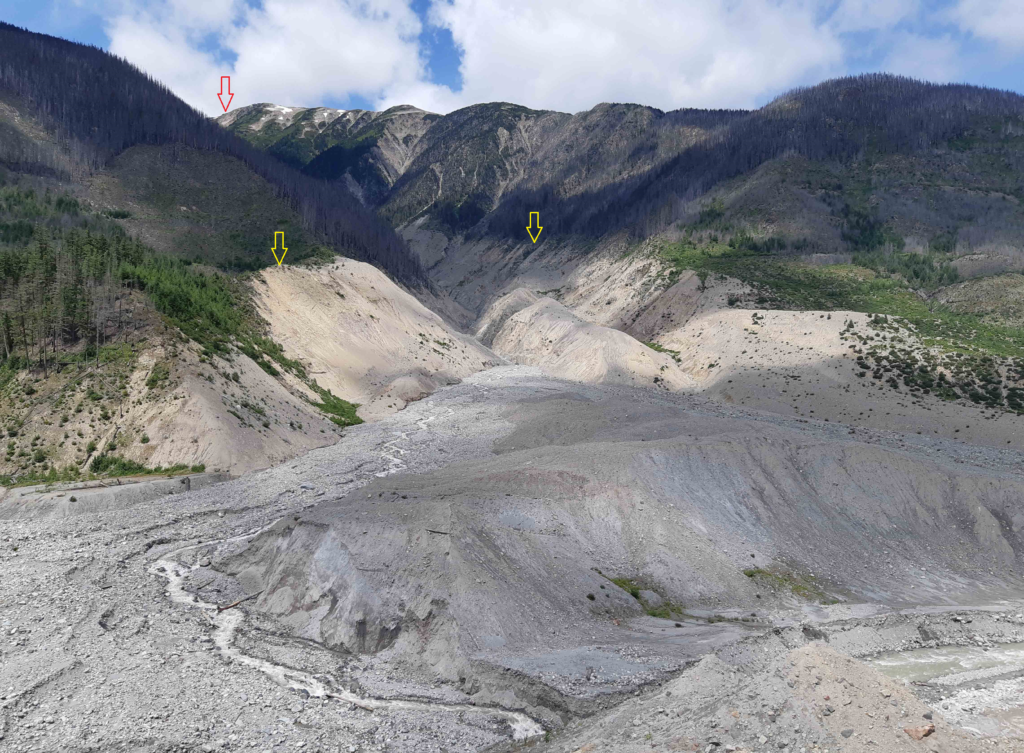
7.2.5 Earle, I (2010) Retrieved April 22, 2021 from https://opentextbc.ca/physicalgeology2ed/wp-content/uploads/sites/298/2019/08/meager-rock-avalanche-2019-1024×753.png
- Photograph of Mount Meager rock avalanche, showing where the slide originated (red arrow, 4 km upstream) and its path down a steep narrow valley. The yellow arrows show how far up the valley the avalanche extended.
7.2.6 Earle, S. (n.d.) Retrieved May 3, 2021 from https://opentextbc.ca/physicalgeology2ed/wp-content/uploads/sites/298/2019/08/depiction-of-the-contribution-of-freeze-thaw.png
- A depiction of the contribution of freeze-thaw to creep. The blue arrows represent uplift caused by freezing in the wet soil underneath, while the red arrows represent depression by gravity during thawing. The uplift is perpendicular to the slope, while the drop is vertical.
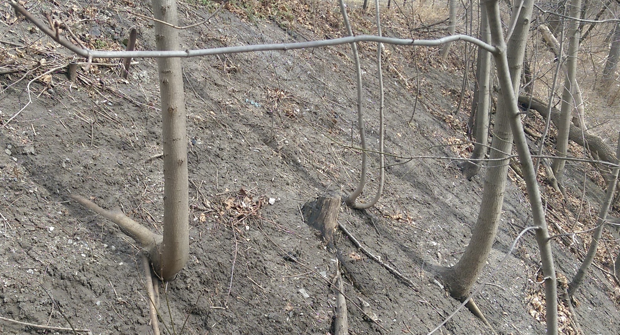
7.2.7 Earle, S. (n.d.) Retrieved May 3, 2021 from https://opentextbc.ca/physicalgeology2ed/wp-content/uploads/sites/298/2019/08/Pistol-Butt.jpg
- An image of trees on a slope that is experiencing creep, notice the bent lower trunk.
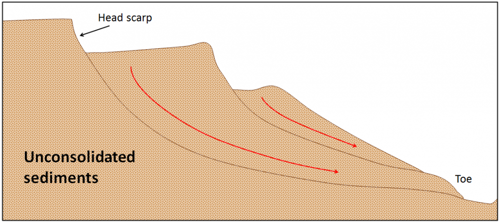
7.2.8 Earle, S (n.d.) Retrieved May 3, 2021 from https://opentextbc.ca/physicalgeology2ed/wp-content/uploads/sites/298/2019/08/motion-of-unconsolidated-sediments-in-an-area-of-slumping-1024×456.png
- A depiction of the motion of unconsolidated sediments in an area of slumping.
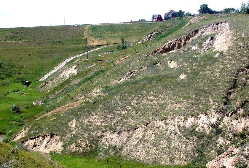
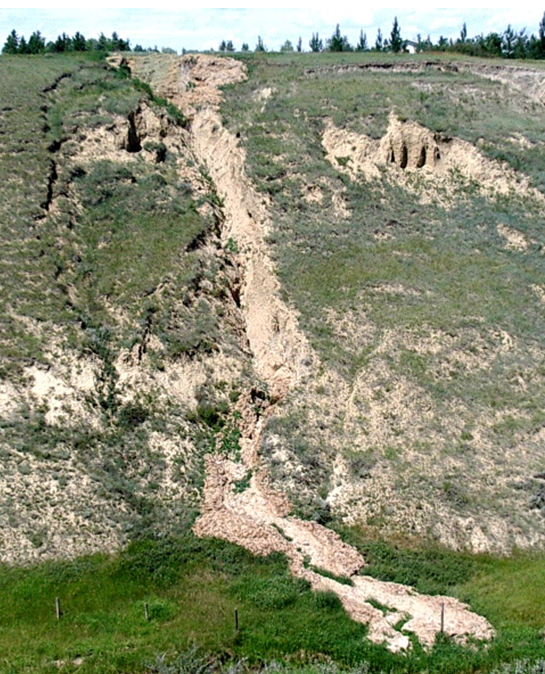
7.2.9 Earle, S (n.d.) Retrieved May 3, 2021 from https://opentextbc.ca/physicalgeology2ed/wp-content/uploads/sites/298/2019/08/slump-along-the-banks-of-a-small-coulee-near-Lethbridge.jpg
- Photograph of a slump along the banks of a small coulee near Lethbridge, Alberta. The main head-scarp is clearly visible at the top, and a second smaller one is visible about one-quarter of the way down. The toe of the slump is being eroded by the seasonal stream that created the coulee.
7.2.10 Earle, S (n.d.) Retrieved May 3, 2021 from https://opentextbc.ca/physicalgeology2ed/wp-content/uploads/sites/298/2019/08/lethbridge-2.png
- A slump (left) and an associated mudflow (center)
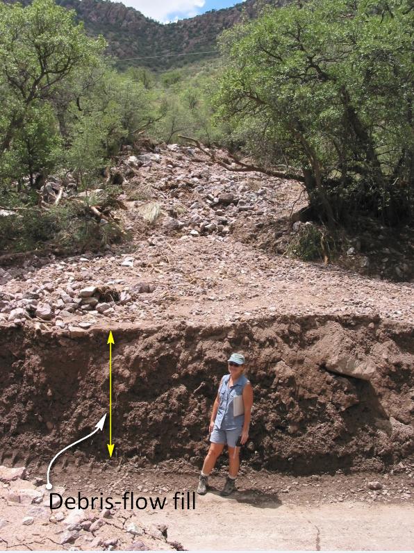
7.2.11 Youberg, A (2016) AZGS Retrieved May 3, 2021 from https://azgs.arizona.edu/sites/default/files/styles/azgs_optimized_large/public/azgs-photo-gallery/Youberg-Huachucas-debrisflowfill.jpg?itok=Ba9LXOcg
- Photograph of debris flow in cross section
7.3
NASA (2018) Landslide threats – NASA satellite data. Retrieved May 3, 2021 from https://youtu.be/h7P55b8LJYU
- Video showing how satellite data is used to predict landslides.
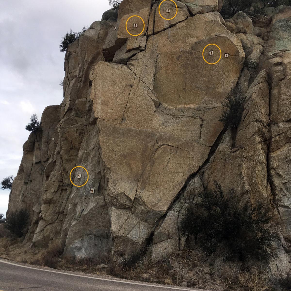
7.3.1 Conway, M. (2017) AZGS. Retrieved April 29, 2021 from https://azgs.arizona.edu/sites/default/files/styles/azgs_optimized_large/public/azgs-photo-gallery/Kitt%20Peak%20road%20cut-rockbolts.jpg?itok=2N7oUnUA
- Photograph showing bolts used to keep rock face in place
ArizonaDOT (2014) US89 Landslide – Repair Begins (August 2014) Retrieved May 3, 2021 from https://www.youtube.com/watch?v=BUvQqiIDYLs
- Video showing the damage and repair to the US 89 due to a landslide.
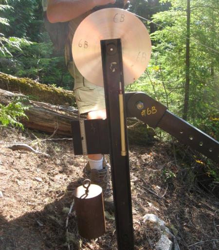
7.3.2 Earle, S (n.d.) Retrieved May 3, 2021 from https://opentextbc.ca/physicalgeology2ed/wp-content/uploads/sites/298/2019/08/motion-monitoring-device-at-the-Checkerboard-Slide-near-Revelstoke.jpg
- Photograph of part of a motion-monitoring device near Revelstoke, B.C. The lower end of the cable is attached to a block of rock that is unstable. Any incremental motion of that block will move the cable, which will be detectable on this device.
7.3.3 Topinka, L. (n.d.) USGS, Mount Ranier over Tacoma. Retrieved May 3, 2021 from https://commons.wikimedia.org/wiki/File:Mount_Rainier_over_Tacoma.jpg
- Picture of Mount Ranier over Tacoma
Figure 7.3.4 A snow avalanche shelter on the Coquihalla Highway. The expected path of the avalanche is the steep un-treed slope above.
7.4
7.4.2 Burian, P. (n.d.) Gondola on the Grand Canal, Venice, Italy. Retrieved May 6, 2021 from https://upload.wikimedia.org/wikipedia/commons/6/6e/Gondola_on_the_Grand_Canal%2C_Venice%2C_Italy.jpg
- Decorative Image of Venice canals
USGS (n.d.) The Science of Sinkholes. Retrieved May 6, 2021 from https://youtu.be/wubMuKDGBuk
- Video explaining the science of sinkholes
7.4.2 Conway, M (2017) AZGS. McCauley Sinks, Holbrook, AZ. Retrieved May 6, 2021 from https://azgs.arizona.edu/sites/default/files/styles/azgs_optimized_large/public/azgs-photo-gallery/McCauleysinks.jpg?itok=x7q58lZC
- Aerial photograph of sinkholes
Instructor Resources
DP22_Ch07_Mass_wasting Text only
